
Passive microwave radiometry is the weather observation hero we need... right now
The world is at a place and time that gives us an unprecedented amount of information regarding weather conditions around the globe. We use this data to build weather forecasts that inform residents whether it would be wise to take an umbrella to work, and also inform industries like agriculture, insurance, and shipping to make both short- and long-term plans that can determine success or failure.
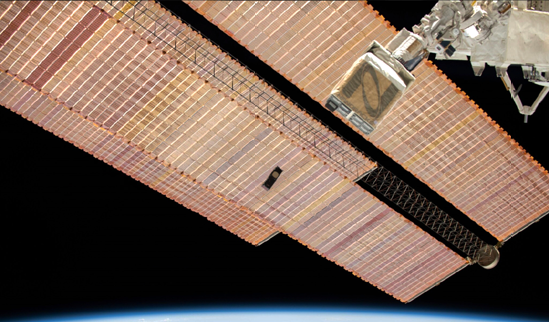
Photo of the Orbital Micro Systems IOD-1 GEMS satellite being launched from ISS.
Data collected from land-based radar and satellite sensors have made information more available than at any other time in history. Yet, even as these tools deliver reliable data that is cut, diced, and quantified by powerful computer algorithms, it is still not enough to meet the needs of society. With macro and microeconomics at risk, as well as safety and security, we need a more comprehensive view of weather, one that can supplement the tools already in widespread use, such as radar and satellite images, and not stymied by distance, cloud cover, and the dark.

An example of the void in reliable weather data occurred July 29, 2011, when an EF-1 tornado, spawned by a supercell thunderstorm, moved through Pennsylvania’s Lehigh Valley. It uprooted more than a dozen trees with winds that reached 90 mph, surprising local citizens.
Officials later confirmed there were actually two tornadoes that touched down in the area that day — which no one was prepared for, and after that fact was uncovered, it was then discovered that more than 11 tornadoes had hit the region. How is that possible? Simply put, the Lehigh Valley region, home to nearly one million people and adjacent to the urban sprawl of Philadelphia, is home to a noted weather radar gap.
What Is A Weather Radar Gap?
Land-based radar beams are as important a tool in a weather forecaster’s arsenal as any other, but they only stretch so far. Across the globe, current, terrestrial radar stations are widely spaced, even in the most technologically advanced countries. In the United States, for instance, the Next Generation Weather Radar (NEXRAD) system is a network of 160 Doppler weather radars jointly operated by the National Weather Service (NWS), the Federal Aviation Administration (FAA), and the U.S. Air Force (USAF). For all the geographical coverage it offers, there are thousands of square miles throughout the U.S. beyond the reach of the system’s beams. Other countries may fare even worse. In Jamaica or Vietnam, for example, the capabilities are limited to just two, coastal radar sites each.
A Dearth Of Data Over Oceans
When optimized, land-based radar can provide excellent pictures of storm conditions, including precipitation density, but coastal-set beams can only reach about 50 kilometers beyond the shore. Anywhere beyond that point is unmeasurable for most tools, especially if relatively low- altitude cloud cover exists. Understanding weather conditions and inclinations across Earth’s vast oceans has a direct impact on transportation and shipping logistics. Large, expensive satellite platforms do acquire some data over oceans, but the frequency and regularity of surveillance is such that they only provide limited value for precise decision-making.
Addressing these inadequately observed areas is necessary for accurate storm tracking and forecasting that can directly affect agriculture, commerce, and the insurance industries. Once data over oceans can be reliably measured, we will begin to have a more reliable picture that will benefit everyone’s interests.
Other Challenges
There also exists another gap in radar’s power to “see” — height. Radar beams project out in a straight line, often at a ceiling of 5,000 or 6,000 feet. By missing out on observable weather data happening above that threshold, the picture composed by monitoring systems is woefully incomplete, potentially leading to costly risk. In addition, conventional satellite images offer us visuals across a large surface area, but they aren’t effective at night. Infrared images offer coverage in the dark, but can’t see inside and through some obstacles.
The Power Of Microwave Radiometers
Weather forecasts are modeled on available data and are interpretations of historical trends and current observations from multiple collection platforms, such as radar, weather balloons and satellite-based sensors. Data gathered by different technologies power the models to make the most accurate interpretations possible. However, without more frequent observations, models struggle to account for short term variations and convective activity which is especially challenging in severe weather forecasting. Among the varied observation technologies providing input to weather models, passive microwave radiometers have been recognized to provide a substantial advantage in understanding weather. Known for its ‘all-weather’ observation characteristics, passive microwave instruments can detect faint microwave signals emitted passively by the atmosphere and earth’s surface at multiple frequencies. From those faint radio signals, information about weather activity inside and through clouds, and in the dark can be extracted. There are fewer than 20 such radiometers aboard government satellites today, resulting in substantial lapses between observations in many regions.
Mitigating the costs and long lead times associated with government satellites, commercially developed cubesats equipped with microwave radiometers can dramatically change the weather data landscape. By installing units on smaller, Low Earth Orbit (LEO) satellites, passive microwave radiometry can measure down and “see” through obscuring cloud coverage to offer an extremely accurate picture of at-that-moment weather conditions that will directly benefit global agriculture operations and enable expansion of insurance market opportunities. Satellite-based observations from even one additional sensor can have a positive impact on the ability to detect and forecast severe weather events.

Filling Those Radar Gaps
There is a global need for improved weather observation where reliable and actionable data could be crucial to the safety and prosperity of a population. To obtain the most robust, 4-dimensional understanding of the weather, we need to fill these radar gaps by using satellites that offer various types of technologies. By taking advantage of the more affordable price point of cubesat and smallsat technology to deploy passive microwave radiometry — alongside infrared, radar, radio occultation, and other satellite observations such as Geostationary Atmospheric Motion Vectors, we can vastly improve the accuracy and timeliness of weather forecasting. It can allow for reliable preparation and mitigation, and safeguard entire populations and economies.
www.orbitalmicro.com

Author Michael Hurowitz serves as chief executive officer and chief technology officer for Orbital Micro Systems (OMS). In these roles, he sets the strategic direction for the organization and oversees the company’s numerous research and development programs, as well as its world-class team of engineers and scientists. Hurowitz brings nearly 20 years of technology and product development experience to the OMS leadership team. Prior to co-founding OMS, he worked with numerous companies, including startups, Fortune 500 companies, university research groups and federal agencies. He serves as a volunteer mentor for the University of Colorado Venture Partners team. He holds a Bachelor of Science degree in Engineering Physics and Public Affairs from the Colorado School of Mines, and is an instructor at the University of Colorado.