
On Christmas Day in 2021, the most complex and powerful space telescope ever built was launched into space — the James Webb Space Telescope (JWST). Part of what makes the JWST so incredible is a set of deployable mirrors that allows the telescope to magnify the most faint sources of light being captured from billions of light- years away. The telescope is also equipped to detect light beyond what the human eye can see, allowing it to measure unique properties of distant objects, such as the chemical structure and presence of gasses through the power of spectroscopy.
Wyvern hyperspectral image capture.
Wyvern is taking a similar approach; however, instead of looking into space, the company is looking down at the Earth in a new way. Wyvern uses incredibly small but powerful satellites that unfold in orbit just like the JWST telescope. These satellites are set to capture details of the Earth hidden to us today just as the JWST is set out to uncover previously invisible information about the universe.

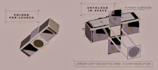
Smallsats & Deployable Optics
JWST is a massive project; it’s budget is well over $10 billion with an anticipated 20 year lifespan. Certainly this is a big project as well as a big telescope, weighing approximately 6,500 kg.
That is where Wyvern differs from the JWST, as the initial satellites will be a fraction of the size and cost of JWST. Each Wyvern satellite will weigh about 20 kg., no bigger than two loaves of bread side-to-side, and will cost less than $10 million.
This is possible thanks to smallsat technology that has developed at a lightning pace over the past decade. The standardized, development framework around smallsat technology has radically reduced costs and the timelines necessary to deliver high-functioning satellites into the market.
However, there is a tradeoff to this streamlined approach of building satellites: size constraints that need to work within prescribed dimensions. For imaging technology, this has posed an immense challenge.
To capture the best quality images possible, whether for the military or government, or the commercial market segments, generally speaking, the bigger a telescope the better. Smallsats, though, are limited in aperture size and focal length due to their size, limiting the quality of the images they can capture from space.
Wyvern is overcoming this barrier by creating deployable optics technology that unfolds a telescope in space, built within the constraints of smallsat design requirements. This technology allows a smallsat to deliver a significant increase in aperture size and that means it can collect more light, obtain a better signal-to-noise ratio as well as increase the resolution and data quality when compared to conventional smallsats.
Hyperspectral Imaging
JWST is equipped with powerful sensors that reveal information around chemical composition and structure captured in its images by measuring light beyond human perception. Wyvern’s satellites will be also equipped with cutting-edge, hyperspectral cameras that will allow them to capture similarly detailed insights around chemical composition.
 Wyvern’s satellite with deployable optics.
Since the 1970s, hyperspectral imaging has been confined to expensive and rigid lab-based environments, used as a main tool in spectroscopy — the study of the absorption and emission of light by matter. Major innovations in chip and filter technology have been taking this powerful lab tool into everyday environments and opening up exciting new possibilities, such as remote sensing opportunities.
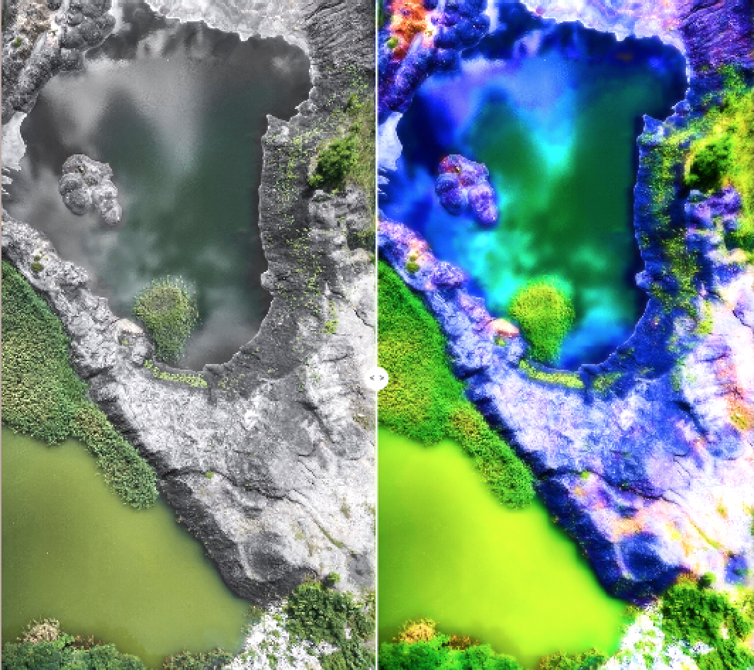
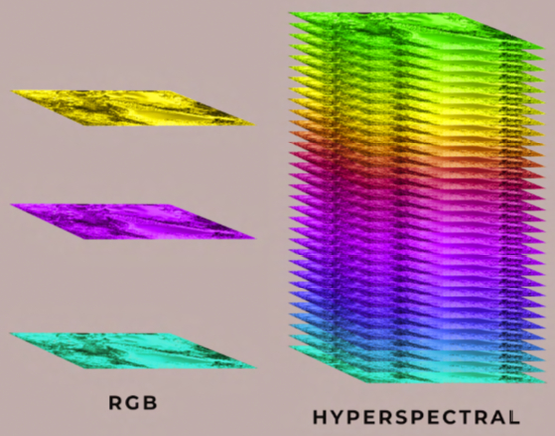
Just as humans each have a unique fingerprint, so does every material and object have a specific spectral signature — a spectral fingerprint. Most conventional cameras on Earth capture only three frequencies of light: red, green, and blue. These frequencies can be used to create beautiful images; however, they lack the specificity and range to identify and measure an object’s spectral signature.
In contrast, a hyperspectral camera can capture tens to hundreds of frequencies of light and extend beyond the visible spectrum, allowing it to capture the critical details that define an object’s spectral signature.
For instance, if you were to take satellite images of a forest which contained a building with a green roof, it would be difficult to differentiate the forest from the roof with most commercial imaging products in the market. Hyperspectral imaging, however, could detect the spectral signature of that roof which would be starkly different from the surrounding environment even if they looked the same to the naked eye.
Then, take that analogy to military/agency/government (MAG) needs... in that same forest, an offensive vehicle may have been colored to blend in with its surroundings as it moves toward its designated mission — here, hyperspectral imaging would be able to determine the position and composition of the offensive vehicle from its surroundings, making it far easy to target and knock out of action by defensive units.
This same principle applies to farmers’ crops. Healthy plants will reflect certain wavelengths that are different from stressed plants. This can inform farmers where pests, weeds, or crop issues exist in targeted areas before conventional imaging or in-person observations could detect these problems. These are just some examples that hyperspectral imaging is helping to unlock.
Hyperspectral bands.
Hyperspectral imaging captures significantly more data compared to its counterparts, such as RGB and multispectral imaging. This data can be used to power complex artificial intelligence and machine learning (AI/ML) algorithms in ways not possible with the remote sensing technology available as of this writing.
The Impact Wyvern blends hyperspectral imaging, deployable optics and a smallsat development approach to offer a quality of satellite data that has never previously been accessible to the market to deliver affordable, high resolution, hyperspectral imagery.
Wyvern technology opens the door for use-cases that did not previously exist. In the next few years, Wyvern is looking to deliver exciting imaging capabilities such as 1 meter VNIR (visible and near-infrared) and 5 meter SWIR (short-wave infrared) that will drastically change what is possible in the Earth Observation (EO) market.
This range of high resolution spectral imaging will change how we look at all things carbon on Earth, opening exciting doors for everything from monitoring greenhouse gas and methane emissions to possibly quantifying carbon credits for farmers.
While this technology is unlocking valuable market opportunities in the near future, Wyvern’s vision is to deliver a new way to measure Earth’s health. This technology will open up significant insights of the world’s ecosystems through the power of hyperspectral imagery that has been inaccessible to scientists and researchers at a global scale.
What’s Next

Within the next year, Wyvern will have their initial generation satellites launched and gathering data for their customers. The imaging capacity of these initial satellites will be able to define a wealth of insights around crop and soil health not currently accessible from space for precision agriculture. Soon after, the company will launch their inaugural DragonEye satellite, their first satellite equipped with deployable optics, capable of reaching the next level of imaging capabilities to access an even broader market.
By 2026, Wyvern anticipates having a constellation of more than 30 satellites in Low Earth Orbit (LEO) able to deliver daily revisits across the globe through their customer-oriented tasking model. While JWST is using deployable optics to explore the universe, Wyvern is turning this technology inwards to entirely change how we use satellite imagery on Earth and re-imagining what is possible in the Earth observation market by considerably reducing the capital cost necessary to capture high resolution hyperspectral imaging.
wyvern.space

Edmonton-based space data company Wyvern was created to provide actionable intelligence that will enable a sustainable future for humanity. Wyvern’s cutting-edge unfolding camera technology will make high-quality, high-resolution hyperspectral imagery from satellites accessible and affordable like never before, unlocking applications in new markets for the very first time. The company is proud to be carving a path for the Canadian space industry.
Author Adam Brown is the Strategic Initiatives Lead for Wyvern. The future of space: How Additive Manufacturing is changing the playing field.