
Recently, the Space Safety Coalition (SSC) issued the “Best Practices for Sustainability of Space Operations.”
This document, co-signed by 21 space companies, advocates that any spacecraft operating at 400 kilometers or more above Earth should include a propulsion system for maneuvering, allowing each spacecraft to move itself out of a potential collision path instead of relying on others to always maneuver around it, as well as a number of other common sense principles.
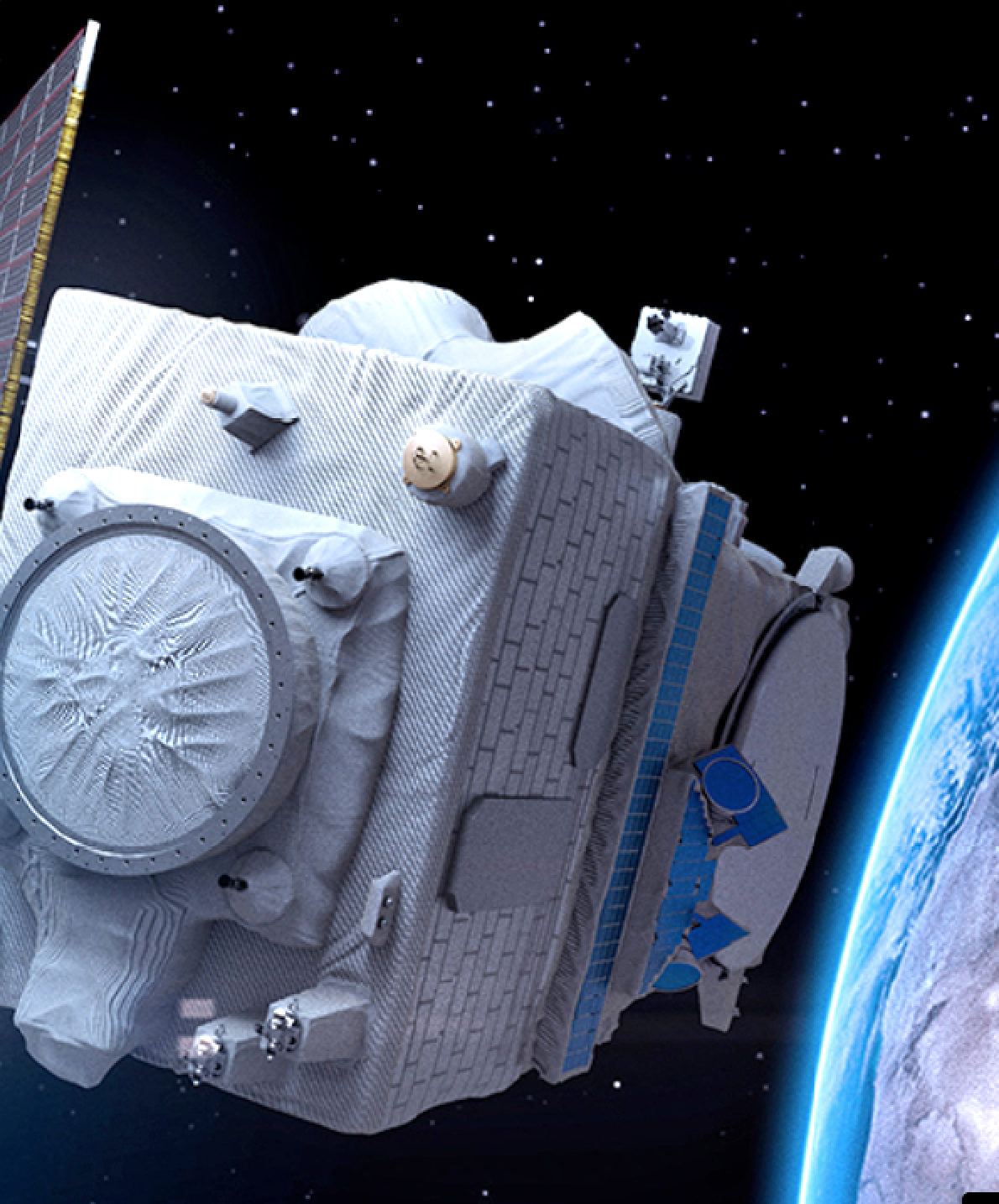
Artistic rendition of Maxar’s Worldview Legion satellite
on-orbit above Earth. Image is courtesy of Maxar Technologies.
This will create a safer space environment for all to operate in now and for generations to come. Maxar Technologies fully endorses the “Best Practices for Sustainability of Space Operations” and encourages Congress to introduce legislation based on these best practices.
We rely on space for our everyday lives. Weather satellites enable us to forecast the next snowstorm, so we can stock up on food. GPS lets us navigate to a new destination, using maps that come from imaging satellites.
GPS also provides the precise timing used for banking transactions and to make it possible for cell phones—and banking transactions—to work. And, of course, there is NFL Sunday Ticket on DirecTV.
Space is also a big place. To put this into context, between the lowest practical orbit (350 km above Earth’s surface) and geostationary orbit (100 times further up, at 35,000 km), the volume of “near Earth” space is about 270 times the volume of Earth.
Current estimates indicate there’s 29,000 objects that are 4 inches or bigger being tracked in that space1, so it seems like it would be pretty empty and we don’t have to worry about collisions, right? Well, not exactly. There’s another aspect of space: orbital velocity. Satellites in space don’t stand still — they zip around in their orbits at high speed. In Low Earth Orbit (LEO) (closest to Earth’s gravitation pull), this is around 7.6 km/sec, or over 16,000 miles an hour.
If two objects in space collide, it’s not a gentle nudge but rather a big resounding KABOOM. This results in a lot more small pieces of debris that need to be tracked.
If you’re lucky, the collision may knock off a corner of your solar array, such as what happened when Maxar’s WorldView-2 satellite was hit in 2016 by a small piece of debris. Fortunately, this had no impact on WorldView-2’s ability to operate.
If you’re unlucky, you get a collision such as the one that occurred between a defunct Russian Cosmos satellite and an Iridium communications satellite in 2009, — that was responsible for nearly doubling the amount of debris in that orbital band.
I’ve mentioned there are about 29,000 tracked objects in space. However, there are a lot more pieces too small to track — an estimated 166 million pebble sized pieces1 are zipping around in space.
While the probability of one of these pieces hitting a satellite is small (on the order of a million to one chance), each collision makes the problem worse. There’s actually a term for this, the Kessler Syndrome, in which each collision makes the problem exponentially worse. We don’t want that to happen, because if it did, it could make certain regions of near Earth space completely unusable for satellites or humans.
Fortunately, we’re quite a long time away from space becoming unusable. Companies are creating new ways to track objects on orbit, including a new commercial solution Maxar is testing, which is the first step in containing the space debris problem.
But space, similar to other common areas (such as the oceans), requires responsible actions by all space operators to keep it usable for future generations. This is where rules of the road come in, and I’d like to lay out a few common sense ones:
Propulsion
Spacecraft operating above 400 km altitude should be required to carry propulsion to execute timely and effective avoidance maneuvers. It’s simply not acceptable for a satellite operator to place the burden of avoiding a collision on other satellite operators — this is everyone’s responsibility.
This is why SSC‘s “Best Practices for Sustainability of Space Operations” advocates for spacecraft operators to adopt space operations concepts that enhance sustainability of the space environment. Why 400 kilometers? It’s a natural dividing line; the International Space Station operates at 403 km altitude (nobody wants to see the movie “Gravity” played out in real life), and below 400 km, atmospheric drag is enough to make those orbits “self-cleaning” (see Figure 1).
Encryption
Satellites with propulsion should be required to have encryption and authentication on their command link, to ensure that only the satellite operator can control how the propulsion is used.
We don’t want a hacker to take control of a satellite and maneuver it into the path of another one to cause an intentional collision.
Navigation
Satellites with propulsion should be able to determine their position, and the operators of these satellites should be required to share this position data (along with any planned maneuvers) with a central repository, such as the Combined Space Operations Center (formerly known as the Joint Space Operations Center [JSpOC]), to facilitate safe navigation by all satellite operators.
The U.S. government is working on a plan to move this repository to a civilian agency, such as the U.S. Department of Commerce to enable a more open and accessible repository for all global satellite operators.
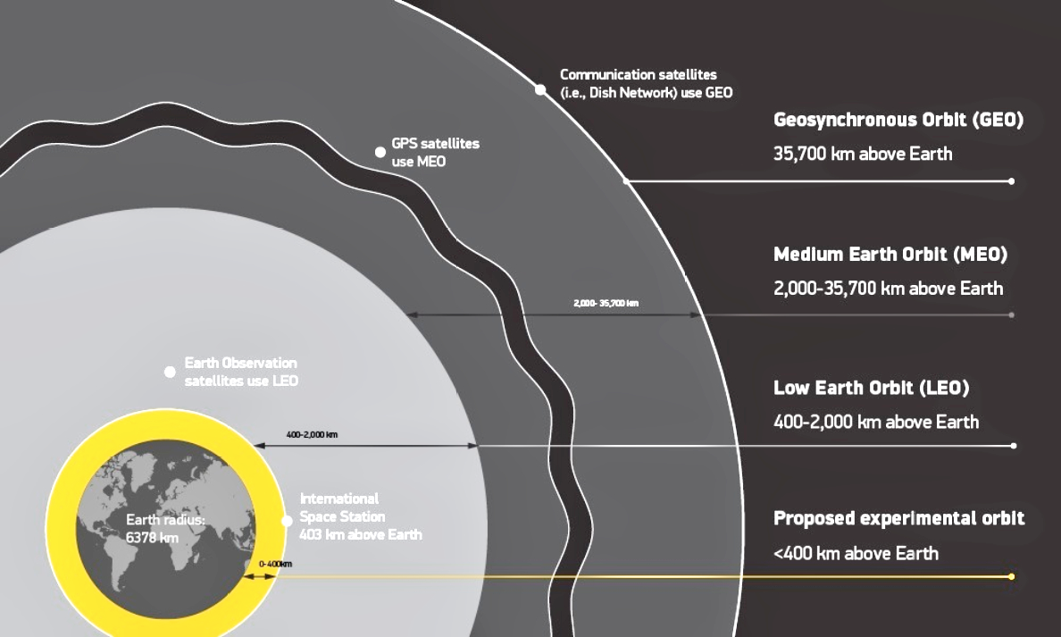 Figure 1
This is akin to the use of Automatic Identification System (AIS) transponders in ocean-going vessels, which broadcast their location to other ships using AIS to enable safe navigation, and the data is availablepublicly online.
Littering
Satellites and launch vehicles need to be designed so they do not throw off debris during or after launch.
While already largely adopted, it’s important that launch providers and space operators have a plan to deorbit launch materials at the end of their life or move them to a safe orbit that’s out of the way and won’t have collision risks.
We could, however, designate the region below 400 km altitude as an “experimental” zone where the listed requirements would not be imposed.
These orbits are low enough that any debris will tend to reenter Earth’s atmosphere, burning up within weeks to months, making them much less of a concern.
And few, if any, commercial or government satellites operate at those altitudes.
Leaving the below-400 km region available without the above restrictions makes operating in space still affordable for operators of the growing number of inexpensive, experimental or educational cubesats.
The commercial and government use of space is accelerating rapidly. It’s time we have a way to regulate space traffic, similar as to how traffic on Earth is controlled.
Even though the first gas-powered automobile was created in the 1880s, it wasn’t until the 1910s (three decades) to bring some sensibility to who had the right-of-way on the road with the invention of the stop light.
Maxar, along with the other co-signers of the SSC, believe it’s time to bring sensibility to space.
We’re asking the U.S. space industry to unite behind these best practices and talk to their senators and representatives about introducing legislation that reflect these best practices.

We ask our international industry partners to bring these ideas to their respective governments for consideration.
The “Best Practices for Sustainability of Space Operations” is a starting point to getting rules of the road established in space — but, in the big picture, all four common sense principles I’ve outlined in this article need to be implemented to keep space a safe environment available now and in the years to come.
References
K. Fletcher, Space Debris: The ESA Approach, European Space Agency, ISBN 978-92-9221-104-2, 2017.
Dr. Walter S. Scott is Maxar’s Executive Vice President and Chief Technical Officer. He founded DigitalGlobe in 1992, which became part of Maxar in 2017. From 1986 through 1992, Walter held a number of technical, program, and department management positions at the Lawrence Livermore National Laboratory, including serving as the assistant associate director of the Physics Department. Prior to this, Walter served as president of Scott Consulting, a Unix systems and applications consulting firm. Walter holds a Bachelor of Arts in Applied Mathematics, magna cum laude, from Harvard College and a Doctorate and Master of Science in Computer Science from the University of California, Berkeley.
Recently, Daniel Nord joined Maxar as Senior Vice President, Chief Product Officer.

Nord joins Maxar from Amazon, where he first led Product Management for Games and then served as GM for Amazon Kids and Family’s Mobile, Content and International divisions. In that role, he led a Product Management organization that tripled the mobile subscriber base, expanded the service to Europe and Asia and released Amazon’s first original franchise, spanning games, shows, books and merchandise.
Prior to Amazon, Nord spent 7 years at Electronic Arts as a studio GM and head of Product Management for Mobile and VR. He has a Master of Business Administration from Stanford University Graduate School of Business and a Bachelor of Science in Computer Science and Engineering from University of Pennsylvania.
In his new role leading the Earth Intelligence Product organization at Maxar, Nord will drive strategy and vision for Maxar’s product roadmap and user experience to accelerate growth across its government and commercial technology customers. He will lead a team of approximately 400 employees at several Maxar locations in the U.S. and Sweden.
Jeff Culwell, who has been with Maxar for 22 years, stepped in to lead the Product organization in 2019. In that role, he enabled the company to operationalize IP to power new products and solutions and drove key technology and infrastructure gains. The Maxar team is grateful for Jeff’s leadership and looks forward to his ongoing contributions as he transitions to a new position in the chief technology office, where he will focus on strategic engineering and internal research and development programs.

Daniel Jablonsky
“Daniel Nord’s keen understanding and successful track record with immersive, digital product lines will be invaluable as we continue to expand our Earth Intelligence product roadmap and scale our offerings in new and existing markets,” said Dan Jablonsky, Maxar CEO. “Maxar’s momentum with the U.S. Army’s digital training environment, One World Terrain, demonstrates the convergence of our existing 3D technologies, world-leading data capabilities and unique IP. As we continue to develop The Digital Globe™, a highly-accurate, 3D, digital twin of the Earth, we see great opportunities to grow product offerings with existing customers and expand into adjacent markets like gaming, augmented reality and autonomous navigation.”
“Maxar’s 30 and 15 cm HD WorldView satellite data, 3D capabilities and unique georegistration IP are key to solving customer problems across the planet. They also enable AI and ML algorithms to more effectively produce high- accuracy, derivative products for a variety of applications and solve customer needs at speed and at scale,” said Daniel Nord. “Maxar is the only company out there doing this with global reach, and I’m excited to show how we can grow the business with existing and new solutions for defense, intelligence and technology customers.”