Ramping up capacity for U.S. gas fields
SATCOM Digital Networks, LLC and HISPAMAR, the Brazilian affiliate of the HISPASAT Group, have reached an agreement for satellite capacity on the Amazonas 2 spacecraft located at the 61 degrees West orbital position.

The new multi-year agreement allows SATCOM Digital Networks to expand its Digistar VSAT platform, which delivers Voice and Data services to the gas fields in the Northeastern U.S., as well as new markets in the Gulf Coast and other growing areas of exploration. The new contract will provide SATCOM with a multi-transponder access plan for extended capacity and flexibility for its industry-leading VSAT platform.
The Digistar VSAT broadband service connects customers in some of the most remote regions and provides multiple solutions to their communication needs. Digistar satellite broadband services can be deployed almost anywhere, making them ideal for business continuity and connectivity in remote, hard to reach locations or temporary sites as found in the Gas and Oil exploration industry.
“After operating on the Amazonas 2 spacecraft for the past year, it is clear that this bird has a tremendous presence and HISPAMAR has been a great partner in expanding our reach in the gas and oil space,” said SATCOM founder and CEO David Chisholm.
“The expansion of the satellite corporate network segment is a fundamental objective for the growth of the HISPASAT Group in the United States market,” said Ruben Levcovitz, HISPAMAR’s Business manager for North America, Central America and the Caribbean.

Additional HISPASAT Group info: http://www.hispasat.com/
SATCOM Digital Networks: http://www.satcomdn.com/
SES brings Boeing in for SES-9 satellite build—coverage for Asia + Maritime
SES S.A. has selected Boeing to build a new communication satellite, SES-9, to serve the fast growing markets in Asia.

The new satellite, ordered through SES’ affiliate company SES Satellite Leasing Ltd., will expand SES’ capabilities to provide Direct-To-Home (DTH) broadcasting and other communications services in Northeast Asia, South Asia and Indonesia, as well as maritime communications for vessels in the Indian Ocean.
The spacecraft will be positioned at the orbital slot of 108.2 degrees East and will provide incremental, as well as replacement, capacity to this well established SES slot over Asia. SES-9 will be co-located with the existing SES-7 and NSS-11 satellites.
SES-9 will be built in Boeing’s El Segundo Satellite Development Center and will be based on the Boeing 702HP platform. The satellite is designed to operate for 15 years in geosynchronous orbit with a 12.7 kilowatt payload and 57 high-power Ku-band transponders (equivalent to 81 x 36MHz transponders).
The spacecraft will carry a xenon ion propulsion system (XIPS) for all on-orbit maneuvering as well as a chemical bi-propellant system for initial orbit raising.
Boeing announced their 702HP satellite series in October of 1995. In 2009, the company introduced and launched heir mid-range version, the 702MP. At that time, the Boeing 702, which has continuously evolved, was designated the Boeing 702HP for “high-power.” The satellite can carry more than 100 high-power transponders, and deliver any communications frequencies that customers request.
The Boeing 702 design is specifically for customers’ requests for a lower cost communications satellite.
Boeing has a 25-year relationship with SES. SES-9 is the 11th spacecraft that SES has ordered from Boeing and the contract includes an option for an additional satellite. Financial details are not being disclosed.
Romain Bausch, President and CEO of SES, said, “SES-9 will greatly expand our transmission capacity over Asia, while adding increased flexibility and redundancy to a strategic orbital slot. SES is convinced that Boeing’s 702HP will prove to be mission-critical in order to provide state-of-the-art, high-power satellite capacity to the thriving markets of Asia.”
Craig Cooning, Chief Executive Officer of Boeing Satellite Systems International and Vice President and General Manager of Boeing Space & Intelligence Systems, said, “Boeing has continuously evolved the 702 design since it was introduced over 15 years ago, allowing us to provide SES a satellite that will be consistent with their business requirements.”
SES infosite: http://www.ses.com/
Boeing infosite:http://www.boeing.com/boeing/bds/
Satellite system brings remote Canada within reach... by Jim Plouffe, Editor, The Lead South Australia

A new satellite system developed in South Australia would enable inexpensive and more rapid monitoring of remote areas of the globe than ever before.
The developers of the Global Sensor Network say the proposed system would provide automatic monitoring of the environment and infrastructure from remote field-based sensors, which collect data and transmit it via low earth orbit satellites.
Sensors attached to pipelines, for example, would instantly detect leaks and breakages and communicate their exact location to authorities.
Climate change-driven movements in sea ice, increases in meltwater and changes in seepage could all be detected no matter where they occurred. The heights of lakes and rivers could be tracked daily during drought or flood, and the system could even provide a way to monitor the health of far distant forests.
The Global Sensor Network technology is the brainchild of the University of South Australia, and involves a unique international collaboration between Canadian and Australian researchers. Technology developed by researchers at the Institute for Telecommunications Research at the University of South Australia (ITR) has been field tested in collaboration with space hardware company COM DEV and vessel tracking organization exactEarth.
The system concept was demonstrated in 2013, when COM DEV and exactEarth provided technical support and access to their satellite and ground system for trials of the GSN conducted in South Australia.
Several months later, ITR researchers traveled to Canada to collaborate with COM DEV and exactEarth to conduct a trial for the University of Waterloo, Ontario to see how the system would perform in the real world.
Ground terminals were placed in three remote sites across Canada, thousands of kilometres apart, to retrieve data on soil moisture, air temperature, wind speed and precipitation. This environmental data was successfully captured, stored and downlinked to a central ground station.
The Global Sensor Network connects low orbit satellites with thousands of remote, low cost sensors through some very clever software and system design elements. Developers say it provides a solution to the problem of expensive satellite monitoring in remote areas.
ITR Acting Director Mr. Jeff Kasparian presented the GSN at the 65th International Astronautical Congress in Toronto in September. He said Australia’s challenge in managing huge areas of resource-rich yet often inaccessible and remote land and water, where monitoring technology is extremely expensive was the impetus for the technology.
Although satellite coverage is available, it is expensive and unsuitable for many purposes.
By contrast, Mr Kasparian said the GSN operates much more efficiently using advanced techniques and architectures, significantly lowering the cost per unit of each measurement taken and transmitted.
* image is courtesy of the Institute of Telecommunications Research.
Also recently announced is that South Australia has just been awarded as the location for the 68th International Astronautical Congress in 2017.
Key contact regarding GSN:
Jeff Kasparian, Institute for Telecommunications Research University of South Australia: Jeff.Kasparian@unisa.edu.au
Information follow-up infopage: https://www.itr.unisa.edu.au/projects/global-sensor-network
The Lead South Australia’s infosite: http://www.theleadsouthaustralia.com.au/
Gilat Satcom POPs up in the U.S. for Congo comms
Gilat Satcom has established a new POP in the U.S. that will provide a new direct satellite route for traffic between The Democratic Republic of Congo and the U.S.
Following a string of new connectivity contracts from operators and enterprises across Africa over the last year, this is Gilat Satcom’s latest investment in its fiber and satellite infrastructure.
The new POP, which is located in Intelsat’s teleport in Maryland on the east coast of the USA, was established to answer growing demand for international broadband connectivity. It means that traffic between the US and Africa will not need to travel via Europe and so latency rates will be significantly reduced and speeds and capacity increased. As a result, Gilat Satcom’s customers will find it much easier to access online video and other rich content.
Gilat Satcom has a growing range of fiber routes in coastal and landlocked Africa and provides telcos, ISPs, Governments and businesses with fast and reliable broadband connectivity at a highly competitive price.
Gilat Satcom is among the first companies in Africa to offer non-stop East to West, coast-to-coast and international connectivity. Its MPLS network connects to the WACS, EASSy and SEACOM undersea cables via fiber local loops across Malawi, Mozambique, Namibia, Nigeria, Tanzania and Zambia and reaches the most remote areas of the continent.
Gilat Satcom’s African headquarters is in Lagos and the company has a number of joint ventures across Africa including Microlink in Zambia and Raga in the DRC.
The Gilat Satcom infosite: http://www.gilat.net/
A COM DEV Int’l + Antrix combo for exactEarth’s M3M satellite
COM DEV International Ltd. has signed a contract with the Antrix Corporation (the commercial arm of the Indian Space Research Organization (ISRO)) to launch the M3M satellite on the Polar Satellite Launch Vehicle from India in 2015.

Dr. V.S. Hegde, Chairman and Managing Director of Antrix (left) and Michael Pley, CEO of COM DEV International (right), at a signing ceremony held at the 65th International Astronautical Congress 2014 in Toronto on October 1, 2014. Antrix Corporation, the commercial arm of the Indian Space Research Organization, will launch the M3M satellite on the Polar Satellite Launch Vehicle from India in 2015.
Dr. V.S. Hegde, Chairman and Managing Director of Antrix (left) and Michael Pley, CEO of COM DEV International (right), at a signing ceremony held at the 65th International Astronautical Congress 2014 in Toronto on October 1, 2014. Antrix Corporation, the commercial arm of the Indian Space Research Organization, will launch the M3M satellite on the Polar Satellite Launch Vehicle from India in 2015.


The M3M satellite was constructed by COM DEV under contract from the Canadian Space Agency/Public Works Government Services Canada for Defence Research and Development Canada and is also subject to a commercial data sharing license with exactEarth Ltd., a joint venture between COM DEV International Ltd. (73 percent) and Hisdesat Servicios Estratégicos S.A.
(27 percent).
Michael Pley, CEO of COM DEV International Ltd., said, “This contract reflects a monumental effort between COM DEV and Antrix, and between COM DEV and the CSA, to close out our original contract and secure the most rapid replacement launch for the M3M satellite, which was withdrawn from its original launch slot on the Russian Soyuz rocket in July this year.”
Peter Mabson, President of exactEarth Ltd., added, “We applaud the Canadian government and COM DEV for moving so rapidly to address this issue and are pleased with the selection of ISRO, which also launched our NTS satellite in April of 2008, the world’s first commercial AIS ship tracking satellite.”
For further information, please visit the COM DEV infosite at http://www.comdev.ca
The Antrix infosite may be reached at http://www.antrix.gov.in/
The exactEarth infosite may be accessed via http://www.exactearth.com/
Bringing more ocean flooring to light...
Scientists have created a new map of the world’s seafloor, offering a more vivid picture of the structures that make up the deepest, least-explored parts of the ocean.
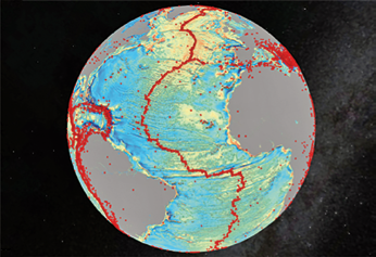
Gravity model of the North Atlantic; red dots are earthquakes. Quakes are often related to seamounts. Credit: David Sandwell, SIO
The feat was accomplished by accessing two untapped streams of satellite data. Thousands of previously uncharted mountains rising from the seafloor, called seamounts, have emerged through the map, along with new clues about the formation of the continents.
Combined with existing data and improved remote sensing instruments, the map, described today in the journal Science, gives scientists new tools to investigate ocean spreading centers and little-studied remote ocean basins.
Earthquakes were also mapped. In addition, the researchers discovered that seamounts and earthquakes are often linked. Most seamounts were once active volcanoes, and so are usually found near tectonically active plate boundaries, mid-ocean ridges and subducting zones.
The new map is twice as accurate as the previous version produced nearly 20 years ago, say the researchers, who are affiliated with California’s Scripps Institution of Oceanography (SIO) and other institutions.
“The team has developed and proved a powerful new tool for high-resolution exploration of regional seafloor structure and geophysical processes,” said Don Rice, program director in the National Science Foundation’s Division of Ocean Sciences, which funded the research. “This capability will allow us to revisit unsolved questions and to pinpoint where to focus future exploratory work.”
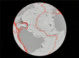
North Atlantic Ocean gravity gradient model showing plate tectonic history of rifting continents. Credit: David Sandwell, SIO
Developed using a scientific model that captures gravity measurements of the ocean seafloor, the map extracts data from the European Space Agency’s (ESA) CryoSat-2 satellite. CryoSat-2 primarily captures polar ice data but also operates continuously over the oceans. Data also came from Jason-1, NASA’s satellite that was redirected to map gravity fields during the last year of its 12-year mission.
“The kinds of things you can see very clearly are the abyssal hills, the most common landform on the planet,” said David Sandwell, lead author of the paper and a geophysicist at SIO.
The paper’s co-authors say that the map provides a window into the tectonics of the deep oceans. The map also provides a foundation for the upcoming new version of Google’s ocean maps; it will fill large voids between shipboard depth profiles.
Previously unseen features include newly exposed continental connections across South America and Africa and new evidence for seafloor spreading ridges in the Gulf of Mexico. The ridges were active 150 million years ago and are now buried by mile-thick layers of sediment.
“One of the most important uses will be to improve the estimates of seafloor depth in the 80 percent of the oceans that remain uncharted or [where the sea floor] is buried beneath thick sediment,” the authors state.
Co-authors of the paper include R. Dietmar Muller of the University of Sydney, Walter Smith of the NOAA Laboratory for Satellite Altimetry Emmanuel Garcia of SIO and Richard Francis of ESA. The study also was supported by the U.S. Office of Naval Research, the National Geospatial-Intelligence Agency and ConocoPhillips.
The National Science Foundation infosite may be accessed at http://www.nsf.gov/