
Quite common for satellites in Low Earth Orbit (LEO) is for them to be equipped with a Global Navigation Satellite System (GNSS) receiver to obtain real-time positioning, velocity, and timing, used for orbit determination of the satellite.

Additionally, GNSS data is commonly used to enable and optimize onboard remote sensing payloads, providing position as well as precise timing information. Until now, however, onboard GNSS positioning accuracy has been limited in comparison to the commercial offerings on Earth.
On Earth, global positioning augmentation techniques, such as precise point positioning (PPP) are used to allow end-users to obtain absolute, high accuracy positioning in real-time by using precise GNSS orbit and clock corrections, multi- frequency GNSS observation data as well as precise observation modelling in the end-user positioning engine. These techniques can provide centimeter level accuracy, in real-time, which enable a host of innovative professional applications across industries that range from surveying to agriculture and maritime and more.
In LEO, however, it is typical for performances to range from meter level in the best cases, although more often accuracies that are in the region of tens of meters. Currently, where greater accuracy (sub-metre) is required, raw GNSS data is downlinked for post processing on the ground to obtain a precise orbit determination (POD) solution. While desired levels of accuracy can be obtained in this way, time latency is incurred, and that adds additional pressure to what is often limited, downlink capacity.
When improved mission performance is linked to enhanced data quality and to reduced latency of information to the end user, there is an emerging trend for satellites to have increased levels of onboard capabilities. With latency reduction being a key driver of performance, Fugro, a leading supplier of satellite positioning services to the maritime industry, was inspired to leverage the firm’s expertise in PPP to develop a high accuracy solution known as SpaceStar® to deliver high accuracy GNSS positioning in real-time onboard LEO satellites.

SpaceStar® was successfully demonstrated in orbit in Augustof 2022 with sub-decimeter positioning being achieved in real-time. This state-of-the-art technology was implemented on hardware with a low size, weight, and power (SWaP) footprint and achieves nominal, real-time performance accuracies of positioning at sub-decimeter level, velocity at less than five millimeters per second, and a sub five nano second timing solution, a tenfold improvement on existing GNSS solutions.
Delivering PPP Corrections To LEO
To generate corrections and to deliver them to LEO, Fugro leverages its existing proprietary ground infrastructure that is designed to meet the demanding requirements of its global satellite positioning business. This infrastructure consists of a ground network of more than 100, globally distributed, reference receiver stations that are all equipped with high-end, geodetic hardware that continuously observes the GPS, GLONASS, Galileo, BeiDou and QZSS constellations.
Raw observation data from the network is processed at Fugro facilities, where it is used to generate the GNSS orbit and clock corrections. The correction signal is then distributed to users in LEO on L-band via a network of geostationary satellites that deliver global coverage.
Onboard Architecture
For the demonstration, the architecture onboard the satellite saw the SpaceStar® software integrated onto a software defined radio (SDR) and flown as a payload. The expectation is that future architecture options will also see SpaceStar® integrated directly at the GNSS receiver level. In both cases, the hardware is integrated with the Fugro L-band tracking and demodulator software for the acquisition and decoding of the correction signal and the Fugro SpaceStar® position engine.
Onboard, the L-band correction data is decoded and forwarded through to the position engine software which applies the corrections to the raw GNSS measurements that is received from the onboard GNSS receiver, to then output the high accuracy position, velocity, and time telemetry, in real-time, onboard the satellite
When the software is integrated at the SDR payload level, the system is enabled to be receiver agnostic as long as the receiver meets the minimum, specified requirements of being capable of receiving dual frequency, observation data and compatible with more than one of the major GNSS constellations.
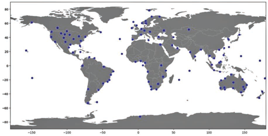
Fugro reference receiver network used for GNSS multi constellation
observations for generation of orbit/clock corrections
Potential Applications For High Accuracy Positioning
As well as the incremental improvement of existing applications that suffer from latency, real-time, high accuracy, precise onboard orbit determination (P2OD) has the potential to unlock areas of radical innovation in nascent fields such as on-orbit servicing and other automated applications where post processing and associated latency is not an option.
RF remote sensing
Techniques, such as such as synthetic aperture radar (SAR), radio-occultation, reflectometry, and RF-geolocation, can all require precise, orbit determination that necessitates the use of ground- based post processing which has an inherent level of built-in latency. For some end users, this is not of concern; however, there may be other users who are concerned predominantly with rapidly changing events, where latency is undesirable and directly diminishes the value of the information. Additionally, some applications also use formation flying techniques that can also benefit from precise real-time positioning of each of the satellites.
Thruster calibration
Thruster calibration and precise orbital maneuvers have the potential to be more efficiently enabled. Direct measurements of delta-v can be observed in real-time to levels of accuracy of less than five millimeters per second. This, potentially, enables better on-orbit characterization of on-board thrusters and that could lead to more efficient fuel usage and, potentially, longer mission life.
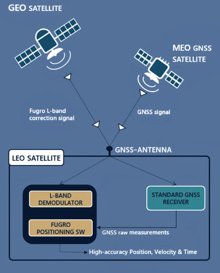
Distribution of corrections on L-band to LEO users via
geostationary satellites
Collision avoidance
Collision avoidance and fleet management in LEO has become an important topic as the risk of conjunctions rise due to increasingly congested orbits. Highly accurate, real-time positioning onboard the satellite has the potential to enable and improve the safety of autonomous satellite collision avoidance systems, reducing false alerts and unnecessary avoidance maneuvers.
Rendezvous and proximity operations
Emerging on-orbit servicing applications can significantly benefit from precise onboard, orbit determination. In close approach and docking application, it can help to enable the approaching spacecraft to safely achieve the desired relative position, alignment and velocity during target approaches which, when combined with other onboard sensors, can help to reduce the risk of collision.

Inter satellite laser link (ISLL) ISLL requires that, during initial acquisition, the transmitting satellite locates the position of the receiving satellite before the laser beam can be accurately pointed. Typically, this is done through traditional RF; however, this could be enhanced and made more efficient with the use of accurate positioning technology. Precise,non-board position and time can also help in facilitating ground-to-space, laser-based communications, both in signal acquisition and increased bandwidth, owing to less uncertainty of the LEO orbit and better time synchronization.
LEO-PNT
LEO-PNT systems will require accurate onboard orbit determination and time synchronisation (ODTS). It is anticipated that LEO PPP solutions will play a role in providing a viable solution to this challenge that is both effective and commercially viable.
www.fugro.com/spacestar

James Bartle
Author James Bartle leads the business development and commercialization activities for Fugro SpaceStar. He may be contacted at Ja.bartle@fugro.com
Fugro is the world’s leading Geo-data specialist, collecting and analyzing comprehensive information about the Earth and the structures built upon it. Adopting an integrated approach that incorporates acquisition and analysis of Geo-data and related advice, Fugro provides solutions. With expertise in site characterization and asset integrity, clients are supported in the safe, sustainable and efficient design, construction and operation of their assets throughout the full lifecycle. Employing approximately 10,000 talented people in 57 countries, Fugro serves clients around the globe, predominantly in the energy, infrastructure and water industries, both offshore and onshore. In 2022, company revenue amounted to 1.8 billion euros. Fugro is listed on Euronext Amsterdam.