
Joakim Espeland, Chief Executive Officer, Quadsat, and Senior Columnist for SatNews Publishers
Recent statistics suggest that Radio Frequency Interference (RFI) is on the rise, which is hardly surprising given the thousands of new satellites on-orbit, the increasing number of ground terminals installed to support those satellites, and the emergence of multi-orbit and multi-band architectures.
Locating the source of interference has always been a challenge, yet, with the vastly increased number of satellites and ground terminals in the mix, it’s becoming even more difficult to detect the origin. The phrase “needle in a haystack” comes to mind.
While most RFI is accidental, usually arising as a result of human error or the equipment not being tested or deployed in its correct operational conditions, it may also be caused deliberately by malicious parties attempting to jam or disrupt a signal.
Whatever the causes, RFI can be detrimental to satellite operators’ ability to provide a high quality, reliable and continuous service. The impact of which can lead to loss of revenue as well as damage to reputation that results many times to reduced credibility within the market.
___________________________________________
Mitigating and Managing Interference
___________________________________________
Satellite operators have, over the years, refined the tools and techniques available for dealing with interference. These include a range of preventative measures such as: antenna registrations to help identify and prevent potential issues with equipment including degradation which, over time, can prevent equipment from operating correctly; improved training to help reduce the risk of human error that could inadvertently cause interference; spectrum management to ensure radio frequencies are used efficiently; and the use of carrier monitoring systems to identify issues that could impact service.
 Of course, even with these mitigation tools, it’s not possible to prevent every occurrence of interference, so operators also need tools to detect and resolve interference when it does happen. These include the use of spectrum analyzers and Carrier ID systems to help detect where interference is coming from; communication and coordination amongst operators to isolate source, and if applicable, agree on moving to other capacities; as well as geolocation which is one of the primary tools satellite operators rely on to find the source of interference.
However, geolocation is not without its limitations and there’s been a great deal of discussion over the last year or so about the need to develop geolocation capabilities, and how doing so would help operators to tackle interference much more effectively.
_____________________________________
Limits of Traditional Geolocation
_____________________________________
The geolocation process involves using satellites to monitor and compare RF signals to triangulate the general area from which interference is being transmitted. Yet, while geolocation can be effective, in cases where satellite based geolocation does not resolve the issue, further investigation is needed.
 While this may be less of an issue in areas with a low population density such as Greenland, parts of Australia, Mongolia, the Western Sahara or Namibia, for densely populated areas, not being able to narrow the focus area down further than a few hundred square kilometers is a real problem.
Once the interference has been geolocated to a defined area, operators are, in some cases, forced to deploy ground teams to physically search for the source. This process takes time, can be resource-heavy, and frequently lead to prolonged service interruptions and downtime.
The process can delay source identification considerably, especially in complex terrain with restricted ground access. Additionally, in scenarios where the interference is intermittent, the likelihood of which is greatly increased, given the highly dynamic nature of both the ground and the space segment, locating the origin of the interference is even more difficult.
With interference occurrences on the rise, operators clearly need to reduce the amount of time and manpower they spend locating the source. Considering the vast number of terminals and satellites that could potentially be the root cause within a geolocated area, it’s clear that operators need the ability to pinpoint the origin much more accurately that they are currently able to. While geolocation has served operators well up in the past, it now needs to be further refined so that it’s better suited to today’s RF environment.
_______________________________________________________
Using UAVs to Enhance Geolocation Capabilities
_______________________________________________________
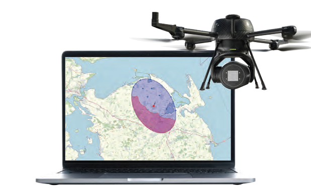
Recent developments around geolocation are showing real promise in significantly reducing the time and effort it takes to pinpoint the exact source of RFI. By leveraging UAV mobility and advanced signal direction finding, operators can narrow down the potential interference zone from hundreds of kilometers squared to an area as small as one hundred meters squared. This approach uses signal data from satellite operators to define a target area to investigate.
Next, UAVs equipped with a directional horn and gimbal launch from optimal launch positions based on signal characteristics, expected detection range, and surrounding terrain. They then perform angular scanning of the area, enabling detection from multiple spatial perspectives and increasing the likelihood of capturing the interference signal.
The UAV sweeps across the target area, gathering data on signal presence, strength, and angle of arrival. After each measurement flight, the collected data is analyzed and the UAV launches and scans again optimize triangulation.
Unlike traditional satellite-based triangulation, which is limited in its spatial resolution, UAVs can get close to the ground, measure signal strength and direction, and continuously refine the target coordinates as they fly. This approach enables fast and cost-effective geolocation of RF interference, even in complex or obstructed environments where ground-based solutions fall short.
___________________________________
Adapting Techniques to Suit
a More Complex Environment
___________________________________
There’s no doubt that the satellite RF environment is becoming harder to manage. LEO and multi-orbit constellations introduce more moving parts into an increasingly congested spectrum.
There are considerable challenges when it comes to designing a test procedure for FPAs, as they are quite different to parabolic antennas. While the industry is striving to get to that point, there are already a great many antennas already in the field that are potentially causing interference.
Additionally, the sheer number of satellites on-orbit, combined with the number of ground terminals in operation further, increases the risk of unintended interference. Then there’s the reality of cost-driven compromises... lower cost equipment often comes at the expense of quality, which means more potential points of failure.
Operators have come a long way in developing more robust mitigation strategies, yet even with these advances, interference remains one of the most persistent challenges facing the industry. UAV-based geolocation is not a replacement for traditional geolocation methods, but rather an enhancement and provides the kind of pinpoint accuracy that can shave days off the investigation process and reduce the need for repeated field visits.
With satellite connectivity expected to underpin everything from autonomous transport to IoT connectivity and 5G backhaul, the stakes will only get higher. The industry can’t afford to be passive about interference.
While prevention remains the ideal, resolution will always be a critical part of the equation, and resolution tools need to evolve to match the complexity of the systems they are required to protect.

Joakim Espeland
Author Joakim Espeland is the President and Co-Founder of Quadsat. He is an entrepreneur, a former Electrical and Mechanical Engineer, Satellite Field Engineer and Examiner. Joakim transformed Quadsat from an idea and concept and built the company to startup and scaleup. He is also a Senior Columnist for SatNews Publishers.
Quadsat manages and optimizes the world’s radio spectrum. The company delivers UAV-based antenna testing and RF measurement solutions to the satellite communications and defense industries. the firm’s technology is redefining how satellite antennas and RF equipment are tested and validated, making comprehensive testing more accessible than ever. By providing vital insights about antenna and radio frequency performance, we are ensuring an efficient radio spectrum, strengthening global connectivity and security. Quadsat is at the forefront of redefining radio frequency testing and spectrum management. Using cutting-edge technology and advanced measurement capabilities, the company brings clarity to the complex world of radio waves—the solutions help industries verify signal integrity and efficiently manage spectrum resources. By unlocking insights into the invisible world of radio waves, Quadsat empowers industries to build safer and more resilient communication systems. The firm’s tools address current and future spectrum challenges, ensuring robust and adaptable infrastructure that supports the demands of an increasingly digital age.
quadsat.com