SSTL—Sailing For Re-Entry Success
Space Debris is becoming an increasingly worrying problem for the space industry. Various methods for bringing inactive satellites back into burn up in the Earth’s atmosphere are being considered by satellite operators.
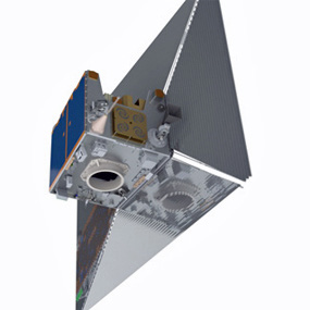
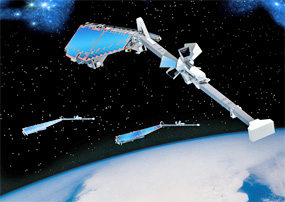
Artistic rendition of TechDemoSat-1 with sails unfurled. Courtesy of SSTL.
TechDemoSat-1 will be escorted back in to the Earth’s atmosphere by one of its eight payloads, a specialized de-orbit sail designed by Cranfield University’s Space Group Team.
The de-orbit sail is the product of several years of Cranfield University’s work on sustainable approaches to space exploration. SSTL’s TechDemoSat-1 gave the Cranfield team the unique opportunity to take-on the challenge of evolving their ideas from designs on paper, to flight-ready hardware. Maintaining a low mass is always a challenge with space projects; the TechDemoSat-1 de-orbit sail is made from a material called
Kapton, which is just one thousandth of an inch, or 25 micron, thick.
Stephen Hobbs, who led the project for Cranfield University, said: “The main challenges were the short timescale, and coordinating all the different elements which were new to us as we moved from just doing paper studies to producing real flight hardware. Individually, several of us had practical project experience including previous space missions, but it was the first flight hardware project for the Space Group as a team.”
The sail will be deployed when TechDemoSat-1 issues a command at the end of its mission. This command will trigger cable cutters to be fired, which will release a restraining belt, and the sail will then be deployed by stored spring energy. Cranfield’s payload will then take up to 25 years to safely guide the TechDemoSat-1 spacecraft into the Earth’s atmosphere to disintegrate.
Exactly how long Cranfield’s de-orbit sail will take to complete the satellite’s course back into our atmosphere will be a subject of great importance to those interested in the management of space debris and the continued exploration and use of space. This process will be affected by a range of things including the amount of solar activity that it is being exposed to, and what altitude the satellite is at when the sail is deployed.
SSTL hopes that TechDemoSat-1, through offering organizations the rare opportunity to demonstrate their payload’s abilities in space, will help the collaborating organizations win substantial international business. TechDemoSat-1 is due for launch later this year.
* * * * * * * * *
Gilat (Wavestream)—Adding A BUC To The Matchbox
Gilat Satellite Networks Ltd. has released to the market their Wavestream Ka-band Matchbox Mini Block Upconverter.
The Matchbox Mini incorporates Wavestream’s Spatial advantEdge™ technology to provide higher output power in smaller, lighter weight packages that are more reliable and use less energy.
The Ka- Matchbox Mini is the next evolution in the Wavestream Matchbox series. The Mini product retains all the features and improves on the performance of its Ka-band predecessor while being one-third (1/3) the size, one-third (1/3) the weight and twice (2x) the linear output power.
The Matchbox features:
• Groundbreaking compact 8W Linear
• Low power draw, high MTBF (mean time between failures)
• Flexible, modular feed-mount design—small enough to fit any antenna
• Switchable bands cover both Ka- Commercial and Ka- Military bands in the same unit
Wavestream products are biased for Class AB operation, drawing less power when backed off to help save valuable energy resources. They generate less heat, ensuring a higher MTBF for greater reliability and lower lifecycle costs. The Ka- Matchbox Mini joins the Matchbox family and is available for order now.
“In creating the Ka- Matchbox Mini, we leveraged the experience gained in fielding over 4,500 50W Ka-band BUCs and over 8,000 Ku-band BUCs,” said Fran Auricchio, President and CEO of Wavestream. “The smaller and lighter Mini retains all the features, high reliability and dependability our customers have come to expect, in a more compact and powerful BUC.”
* * * * * * * * *
Astrium—SWARM Participants En Route To Plesetsk
The first of the three Astrium-built Swarm research satellites is on its way to the Plesetsk Cosmodrome.
An Ilyushin-76, headed for Russia, took off from Munich Airport with the first satellite, while the remaining two satellites, plus the test and installation equipment, will follow at two-day intervals. This amounts to a total of 63 tons of freight.
The trio of satellites will be launched simultaneously from Plesetsk (around 800 kilometers northeast of Moscow) on a single Rockot launch vehicle in November 2013.
Astrium is the European Space Agency’s (ESA) prime contractor for the Swarm mission. The purpose of the Swarm mission is to analyze, in unprecedented detail, the geomagnetic field and its evolution. The findings will help improve our understanding of the Earth’s inner workings and its interaction with the space environment.
The three identical Swarm satellites will be launched into a polar orbit at an altitude of 490 kilometers and will carry out the most accurate survey to date of the Earth’s magnetic field and its changes. Swarm will, in a manner of speaking, follow in the footsteps of Jules Verne’s novel “Journey to the Centre of the Earth.”
Today, however, it is not always necessary to dig or drill to take a closer look at the composition and workings of the Earth’s interior. Thanks to the development of ‘satellite remote sensing’, Swarm can achieve this goal from orbit.
The Earth’s gravitational and magnetic fields offer direct insights into the workings of its interior: from the variations these fields display at different times and places, scientists can draw conclusions about the dynamic processes taking place deep beneath the planet’s surface, in the outer core.
Extremely accurate, high-resolution readings of the geomagnetic field’s strength, orientation and fluctuations, complemented by precise navigation and velocity data, along with measurements of the electric field intensity, will provide the observational data required to distinguish between the various sources of the geomagnetic field and to explain them through models.
Observation of these aspects from space offers a unique opportunity to take a closer look both at the composition of the interior of our planet and at the processes at work there.
The mission will also enable scientists to analyze the Sun’s influence on the Earth. In addition, improvements in our knowledge of the geomagnetic field are expected to provide benefits of a practical nature, such as more accurate navigation for ships and aircraft, the discovery and access to natural resources below the Earth’s surface, improved global weather forecasting, and timely warnings of dangerous solar radiation.
Astrium began developing its first satellite for magnetic field research in deep space—the ISEE-B—back in the late 1970s. This work has continued with the development of the four-satellite Cluster constellation which has been in orbit and operating since 2000. In the field of low Earth orbit satellites, the German Champ satellite, which collected data from 2000 to 2010, was built to an Astrium design.
The Swarm constellation is now the logical next step down this path. In terms of technology, Swarm has benefited from the legacy of both the Champ satellite and Cryosat, the polar ice research satellite—both projects led by Astrium.
Swarm is the ‘Three-satellite-mission’ in ESA’s ‘Living Planet’ program. Its mission is to study the Earth’s magnetic field. In its role as industrial prime contractor, Astrium (Friedrichshafen) is responsible for developing and building the Swarm satellites.
* * * * * * * * *
Naval Research Lab—The Space Between...
Scientists at the U.S. Naval Research Laboratory (NRL) have determined that there has been an increase in bright polar mesospheric clouds (PMCs) in the last two years, an unexpected result since these clouds are generally thought to be less prevalent during conditions of high solar activity which acts to destroy the tiny ice particles.
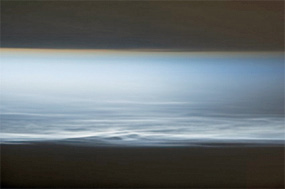
Polar mesospheric clouds–also known as noctilucent, or “night shining” clouds–are formed above the Earth’s surface near the mesospherethermosphere boundary of the atmosphere, a region known as the mesopause. (Photo: Image Science and Analysis Laboratory, NASA-Johnson Space Center. “The Gateway to Astronaut Photography of Earth.”)
Their research suggests that the man-made effect of water released by exhaust from space traffic during recent years has overwhelmed the effect of higher solar activity. This research was published in the June 6, 2013, issue of Geophysical Research Letters.
“This new understanding of weather at the edge of space serves to test high altitude weather and climate models of the upper atmosphere, including the co-located D&E-regions of the ionosphere which is critical for improving models of over-the-horizon-radar (OTHR) propagation,” explains NRL’s Dr. David Siskind, a scientist in NRL Space Science Division and principal investigator for the research.
Each summer, the Arctic and Antarctic atmospheres at very high altitudes (the upper mesosphere, 80 to 100 km) become extremely cold with temperatures well below -100°C, despite the presence of 24 hours of sunlight. These very low temperatures allow the atmosphere to become supersaturated, and enable thin, wispy ice clouds to condense on nuclei of meteoric dust and smoke particles.
Due to the possibility that this region of the atmosphere may be changing due to man-made effects, NASA launched a dedicated satellite, the Aeronomy of Ice in the Mesosphere (AIM) mission six years ago. Scientists used the AIM data to test atmospheric analyses provided by special high altitude prototype versions of the then-operational Navy Global Forecast System (NOGAPS).
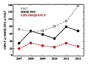
Variation of mid summer polar mesospheric clouds observed by two instruments on the NASA AIM satellite from 2007-2012. The Solar Occultation for Ice Experiment (SOFIE) measures ice water content (IWC) which is a proxy for cloud brightness; the Cloud Imaging and Particle Size Experiment (CIPS) records the frequency of occurrence. (Image courtesy of the Naval Research Lab)
Previous studies by NRL scientists had shown this high altitude version of NOGAPS could demonstrate how variations in lower atmospheric weather conditions thousands of miles away might “teleconnect” to the Arctic and cause PMCs to vary.
NRL scientists also believe that weather at the edge of space is sensitive to solar activity. An increase in the ultraviolet output of the sun can cause small temperature increases—NRL scientists expected these temperature increases to inhibit the formation of ice particles. In addition, increased ultraviolet light from the sun destroys water vapor molecules, making the already bone dry upper atmosphere even drier.
Solar activity was unusually low for the first four years of the AIM mission, from 2007 to 2010, but has increased in the last two years.
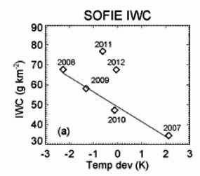
The ice water content (IWC) from the SOFIE instrument on AIM shows that cloud brightness varied linearly with stratospheric temperatures (the x-axis is a measure of these temperatures) for the first 4 summers of the AIM mission. The excess cloud water content seen in 2011 and 2012 is clearly displayed. Based upon theories of solar cycle activity, IWC values of about 40 were expected for 2011 and 2012. (Photo: U.S. Naval Research Laboratory)
Before the AIM mission, researchers estimated that the clouds should have decreased by 20 to 30 percent because of the high solar activity. Researchers were quite surprised to see that the occurrence of PMCs remained high and even increased. By studying the frequency and ice water content (IWC, which is a measure of cloud brightness) of the ice with weather conditions in the lower stratosphere, scientists see irregularities between the 2011 and 2012 measurements compared with measurements from the previous four years.
Instead of 20 to 30 percent decreases, they saw up to 30 percent increases.
Researchers suggest that the explanation lies in a water vapor source from rocket exhaust. NRL scientists were the first to discover that individual PMCs could be formed by the exhaust from the space shuttle. Those earlier studies also suggested that these effects might appear in the long-term PMC record.
The new results confirm that suggestion and also suggest that this effect can dwarf that from solar cycle variations. A record of H2O injected into the upper atmosphere by space traffic over the six-year period from 2007 to 2012 shows low amounts from 2007 to 2010 and then large increases in 2011 to 2012, precisely what is needed to explain the inconsistent PMCs.
NRL scientists are particularly interested in the 2012 anomaly as it occurred after the termination of the shuttle program.
Thus the possibility that the space traffic contribution to PMCs may persist post-shuttle is one that will be of intense interest as new data is studied over the next several years.
Information for this story was provided by the Naval Research Lab.
* * * * * * * * *
EMC + STM—An Acquisition Of Note
Emerging Markets Communications (EMC) has acquired STM and its affiliate entities Global IP and Vodanet Brasil.
Global IP is a global satellite connectivity services provider, specializing in the mobility, maritime and oil and gas markets. Vodanet serves as an operating company in Brazil and is fully licensed to provide VSAT services both onshore and offshore.
STM is a leading hardware manufacturing company for the satellite industry with proven experience developing high quality and bandwidth-efficient, VSAT products based on the DVB-RCS2 standard. The combined organization has over 20 years of industry experience in 150 countries with over 150,000 VSAT terminals deployed in to service.
EMC’s unique satellite connectivity offering now includes a global C- and Ku-band footprint for high availability enterprise networks with the largest number of wholly-owned field support locations in the industry. EMC owns and manages 32, in-country, field support centers worldwide.
These support centers are staffed with EMC-certified engineers, spare parts, test equipment and manage all logistics in deploying, maintaining and repairing services for onshore and offshore customers.
Additional mobility customers include fishing boats, ferries, high-speed trains and helicopters. These customers leverage EMC’s wholly-owned support centers and global Ku-band and C-band networks to maximize their business performance on land, in the air or at sea.
EMC’s additional geographic locations broaden its reach in servicing customers worldwide. In addition to being the largest VSAT provider in Africa, EMC now has a solidified presence in Latin America, Europe, the Middle East and Indonesia, creating a complete global network with 32 wholly-owned support centers worldwide.
In Brasil, a key market for oil and gas, EMC is now one of the only global providers with a direct, Anatel-approved, VSAT license for delivering services in the country, both onshore and offshore.
EMC also has in-country teleport infrastructure and field support offices in Rio, Sao Pablo, Brasilia and Bello Horizonte, equipped with engineers to quickly respond to customer demands. In Brasil, EMC has approximately 8,000 VSAT terminals in service for the oil and gas, telecom, and government industries.
Technology Leader EMC’s research and development facilities in United States and India, and its 18 patented technologies, combined with STM’s research and development facilities in Norway and innovative design and manufacturing of high quality, bandwidth-efficient satellite systems, positions EMC as a leading provider of the DVB-RCS2 standard.
EMC’s patented bandwidth technology will optimize the SatLink™ networking system in providing IP-based voice, data, interactive video, mobility and Coms-On-The-Move (COTM) solutions for mobility customers and SatLink™ users in general.
* * * * * * * * *
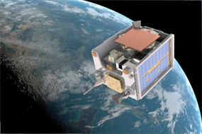
M.I.T.—Greater Reach For CubeSats
The future of satellite technology is getting small—about the size of a shoebox, to be exact. These so-called “CubeSats,” and other small satellites, are making space exploration cheaper and more accessible: The minuscule probes can be launched into orbit at a fraction of the weight and cost of traditional satellites.
View of a CubeSat equipped with an inflated antenna, in a NASA radiation chamber. (Credit: Alessandra Babuscia)
But with such small packages come big limitations—namely, a satellite’s communication range. Large, far-ranging radio dishes are impossible to store in a CubeSat’s tight quarters. Instead, the satellites are equipped with smaller, less powerful antennae, restricting them to orbits below those of most geosynchronous satellites.
Now researchers at MIT have come up with a design that may significantly increase the communication range of small satellites, enabling them to travel much farther in the solar system: The team has built and tested an inflatable antenna that can fold into a compact space and inflate when in orbit.
The antenna significantly amplifies a radio signal, allowing a CubeSat to transmit data back to Earth at a higher rate. The distance that can be covered by a satellite outfitted with an inflatable antenna is seven times farther than that of existing CubeSat communications.
“With this antenna you could transmit from the moon, and even farther than that,” says Alessandra Babuscia, who led the research as a postdoc at MIT. “This antenna is one of the cheapest and most economical solutions to the problem of communications.”
The team, led by Babuscia, is part of Professor Sara Seager’s research group and also includes graduate students Benjamin Corbin, Mary Knapp, and Mark Van de Loo from MIT, and Rebecca Jensen-Clem from the California Institute of Technology. The researchers, from MIT’s departments of Aeronautics and Astronautics and of Earth, Atmospheric and Planetary Sciences, have detailed their results in the journal Acta Astronautica.
An inflatable antenna is not a new idea. In fact, previous experiments in space have successfully tested such designs, though mostly for large satellites: To inflate these bulkier antennae, engineers install a system of pressure valves to fill them with air once in space—heavy, cumbersome equipment that would not fit within a CubeSat’s limited real estate.

Babuscia raises another concern: As small satellites are often launched as secondary payloads aboard rockets containing other scientific missions, a satellite loaded with pressure valves may backfire, with explosive consequences, jeopardizing everything on board. This is all the more reason, she says, to find a new inflation mechanism.
The team landed on a lighter, safer solution, based on sublimating powder, a chemical compound that transforms from a solid powder to a gas when exposed to low pressure.
“It’s almost like magic,” Babuscia explains. “Once you are in space, the difference in pressure triggers a chemical reaction that makes the powder sublimate from the solid state to the gas state, and that inflates the antenna.”
Babuscia and her colleagues built two prototype antennae, each a meter wide, out of Mylar; one resembled a cone and the other a cylinder when inflated. They determined an optimal folding configuration for each design, and packed each antenna into a 10-cubic-centimeter space within a CubeSat, along with a few grams of benzoic acid, a type of sublimating powder. The team tested each antenna’s inflation in a vacuum chamber at MIT, lowering the pressure to just above that experienced in space. In response, the powder converted to a gas, inflating both antennae to the desired shape.
The group also tested each antenna’s electromagnetic properties—an indication of how well an antenna can transmit data. In radiation simulations of both the conical and cylindrical designs, the researchers observed that the cylindrical antenna performed slightly better, transmitting data 10 times faster, and seven times farther, than existing CubeSat antennae.
An antenna made of thin Mylar, while potentially powerful, can be vulnerable to passing detritus in space. Micrometeroids, for example, can puncture a balloon, causing leaks and affecting an antenna’s performance. But Babuscia says the use of sublimating powder can circumvent the problems caused by micrometeroid impacts. She explains that a sublimating powder will only create as much gas as needed to fully inflate an antenna, leaving residual powder to sublimate later, to compensate for any later leaks or punctures.
The group tested this theory in a coarse simulation, modeling the inflatable antenna’s behavior with different frequency of impacts to assess how much of an antenna’s surface may be punctured and how much air may leak out without compromising its performance. The researchers found that with the right sublimating powder, the lifetime of a CubeSat’s inflatable antenna may be a few years, even if it is riddled with small holes.
Babuscia says future tests may involve creating tiny holes in a prototype and inflating it in a vacuum chamber to see how much powder would be required to keep the antenna inflated. She is now continuing to refine the antenna design at JPL.
“In the end, what’s going to make the success of CubeSat communications will be a lot of different ideas, and the ability of engineers to find the right solution for each mission,” Babuscia says. “So inflatable antennae could be for a spacecraft going by itself to an asteroid. For another problem, you’d need another solution. But all this research builds a set of options to allow these spacecraft, made directly by universities, to fly in deep space.”
Editor’s note: The above story is based on materials provided by Massachusetts Institute of Technology. The original article was written by Jennifer Chu.
* * * * * * * * *
Astrium—First Flight Proves Endurance
Astrium has successfully completed the first flight of its long endurance Zephyr, solar powered, High Altitude Pseudo-Satellite (HAPS), since it acquired the assets of the Zephyr program from QinetiQ in the UK in March of 2013.
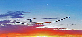
The flight of the Zephyr took place at the Yuma Proving Ground in Arizona, USA, in August 2013. Astrium’s HAPS program has been running in conjunction with its EADS partners, Cassidian and Innovation Works, for several years.
The solar powered Zephyr holds the world record for flight endurance, having flown for more than two weeks at altitudes in excess of 70,000 feet.
This latest flight was to demonstrate a number of improvements in the design and operation of the vehicle, to enable future long-endurance operational trials.
“We are delighted that we have shown not only that the Astrium Zephyr is the most advanced High Altitude Pseudo-Satellite in the world but also that Astrium and the UK Ministry of Defence were able to put together this program to demonstrate persistent Intelligence, Surveillance & Reconnaissance (ISR) capability and to complete a full flight with the support of the U.S. Department of Defense within only four months,” said Jens Federhen, Astrium’s HAPS program manager.
* * * * * * * * *
Harris Corporation—GOES-R Receivers Testing Successful
Five simulators that will help the National Oceanic and Atmospheric Administration (NOAA) user community to prepare for the advent of a new generation of geostationary weather satellites have been delivered by Harris Corporation (NYSE:HRS).
The Geostationary Operational Environmental Satellite – R Series (GOES-R) will provide continuous imagery and atmospheric measurements of Earth’s Western Hemisphere and space weather monitoring. The advanced spacecraft and instrument technology used on the GOES-R series will result in more timely and accurate weather forecasts by supplying meteorological data with much greater detail and clarity than the current GOES satellites provide. The GOES-R series will be a primary tool for the detection and tracking of hurricanes and severe weather.
To accommodate the anticipated 40-times increase in data to be ingested, processed and distributed, receiving systems operated by satellite weather data users must be replaced or modified to support this high-resolution data—similar to upgrading a TV antenna to receive HD video broadcasts at home. The Harris GOES-R Rebroadcast (GRB) simulators produce a full-resolution stream of science data similar to what will be produced during actual operations of the satellites. This will enable GOES data users, such as the National Hurricane Center, to test receivers well in advance of the launch date to ensure a smooth transition.
“None of the existing receivers will work with this new generation of weather data,” said Romy Olaisen, vice president, Civil Programs, Harris Government Communications Systems. “Harris worked very closely with the customer, and within a challenging schedule, to ensure that the simulators meet the unique needs of the weather community and aids vendors in manufacturing receivers.”
Harris is the prime contractor and systems integrator for the contract to produce the GOES-R Ground Segment, which will process approximately 60 times more data than is possible today, and deliver weather products to the National Weather Service and more than 10,000 other direct users.
* * * * * * * * *
SatLink + i24 News—Distribution Delivery
i24 News has selected SatLink Communications Ltd. for the global distribution of three international news channels.

The new 24/7 broadcaster will use Satlink’s comprehensive satellite and fiber distribution network to deliver its multi-lingual channels across Europe, the Middle East, Africa and Asia, as well as providing other services including: Production, Satellite News Gathering (SNG), Occasional Use coordination, fiber to the UN buildings in New York, to Gaza and Ramallah as well as content monitoring.
As a new player in the market, i24 needed a satellite communications partner that was able to support them in delivering fast, reliable news from the Middle East to a global audience. i24 News will also be taking advantage of SatLink’s Content Monitoring solution, a service, which monitors all of the news feeds in the Middle East in Arabic, Farsi and English and provides reports and analysis direct to i24 of all of the current news emerging from the region. In addition, SatLink’s Occasional Use (OU) services will enable the swift and cost effective delivery of bundled, end-to-end solutions including production, SNG’S, OU satellite capacity, global fiber optic network, streaming and added value services.