
Nowadays, one observes a number of technology and market trends that have a significant impact on the remote sensing industry. One key trend is reducing the size and weight of satellites in low-earth orbit. Improved technology, including deployable antennas and miniaturized propulsion systems, enables satellite operators to avoid using large, expensive satellites for many applications. Instead they replace them with groups of small satellites that can be launched together with tens of other satellites, or launched individually using a small-lift launch vehicle.
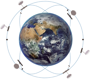
In addition to reducing cost, the increased number of Earth Observation (EO) satellites in orbit creates new capabilities. For example when the same surface area is imaged from many different orbital positions, one can use stereo image processing techniques to generate 3D height measurements of that area.
Other important technological factors include the Big Data revolution and the maturity of cloud computing. These technologies combined with tools like machine learning and data analytics make it possible to obtain previously unknowable information about our world on a persistent, global, and high-resolution basis.
Another trend is miniaturization of satellite sensors such as synthetic aperture radar (SAR). Thus, commercial satellite-based radar monitoring services are becoming more available. SAR technologies have already been practically applied in many industries, but due to high satellite cost and power consumption, access to high-quality commercial SAR data is limited to that provided by a small number of non-US, government-built, dual-use satellites (which always give priority to government users).
Data Analytics Becomes the Industry Standard
As of this writing, most industries have experienced digital transformation. This transition will continue to take place in nearly all industries and the processes governed by them. Industry leaders need detailed and up-to-date industry-specific information in order to optimize their management processes for the digital era. In fact, many industries increasingly demand processing and work-flows managed, in part, by geospatial information systems.
At the same time, geospatial information systems are unfamiliar to most industrial enterprises. Therefore, it is important to provide them with fast and easy access to open and proprietary data sets, and to equip them with user-friendly geospatial data processing tools.
On the other hand, increased data availability inspires development of new applications thereby increasing market demand. However, despite its availability only 5 percent of the imagery collected by EO satellites ends up being used. Why? Because there are still many barriers preventing the industry from making remote sensing tools useful for everyone.
EOS’ mission is to completely remove these barriers as soon as possible. EOS is simplifying access to geospatial data and developing new data processing tools in an effort to accelerate growth of this nascent industry.
EOS makes complex problems simple, so that anyone can access remote sensing services that were once available to only the most wealthy and sophisticated governments and corporations.
From Analytics to Data
Since 2015, EOS has offered cloud-based services to manage large volumes of geo-information data, as well as specific analytical solutions which apply satellite remote sensing data to a wide range of industries. Customers use EOS solutions for security, ecological health monitoring, environmental management, agriculture, etc. EOS clients and partners are world-leading companies in data analysis, agriculture, and insurance sectors — as well as governments and other state and non-commercial organizations.
Integration of different technologies is key. All EOS-developed algorithms and methods use advanced data processing and analysis technologies, including data combination methods known as Data Fusion. EOS’ experience proves that the most accurate and useful result can be achieved by synergistically combining data from different sensors: optical images, radar data, LIDAR point clouds, etc. to enhance both the quality of the individual data sets as well as the accuracy of higher level analytical results such as object detection, crop classification, height estimation, etc.
During all these years, EOS has strived to carefully study each industry vertical and suggest intelligent solutions based on the available data. Each industry vertical represents new data set(s), new task(s) from the end user, and new challenges. Each step forward in this regard is a positive contribution to the industry of data analytics. EOS creates an ecosystem which transforms the science of remote sensing into practical business cases.
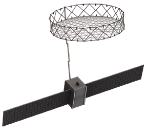
Artistic rendition of a SAR satellite.
Image is courtesy of EOS.
EOS is a vertically integrated company working on multiple remote sensing projects, including the development of its own satellite constellation designed to meet current and future market needs. Using more persistent and versatile data sources will further enhance EOS analysis results.
In 2019, EOS announced the launch of a new division — EOS SAR — whose mission is to develop low-cost high-performance synthetic aperture radar (SAR) sensors intended for deployment in a constellation of small satellites.
In addition, EOS began production of optical satellites in 2018. The first phase of EOS satellite constellation consists of 12 satellites providing 2-3 hours revisit time for a given area. The first SAR satellite launch is expected in 2022, with commercial constellation operations beginning in 2023.
EOS decided to develop its own constellation of remote sensing satellites after researching practical business cases in commercial and government EO markets. Despite a great amount of open satellite data, the markets still lack persistent, high-quality, high-resolution data sources.
New Horizons — SAR constellation
EOS satellite constellation reduces system latency, enabling delivery of analytical results to the end user in just a few hours. Using multiple satellites compared to one satellite dramatically reduces the time between consecutive passes over the same area. Satellites with optical sensors are widely used in commercial constellations today. As of now, optical sensors have mostly adapted to the small satellite paradigm and their technology is readily available.
However, satellite-based optical sensors cannot function in cloudy weather or at night. Accounting for these and other limiting factors, information from satellites with optical sensors can only be used four months out of a year - and the satellites are essentially useless during the rest of the time.
Traditionally, SAR satellites are rarely used for commercial applications due to their large size, technical complexity, and high costs. As of now, however, EOS has significantly reduced the size and complexity of SAR sensors and antennas, and opened a huge opportunity for growth in the EO market.
All these factors, as well as the market demand for analytic results 24/7, contributed to EOS choice of SAR technology for its remote sensing constellation.
EOS’ engineers have already designed a radar prototype and are moving ahead with the development of a low-cost high-performance SAR payload for small satellites with ultra-high ground resolution down to 25 cm.
EOS SAR satellites will operate in Stripmap and Spotlight modes (including interferometry) and will cover a wide range of applications. EOS is also considering dual-frequency SAR in X-band and S-band on a single satellite. Dual-band operation increases versatility for all weather imaging and improves object-ground contrast. A special configuration of the radar front end allows for imaging of selected areas in both bands in a single orbit.
EOS SAR payload incorporates a deployable reflector antenna developed in-house at EOS. This proprietary antenna technology enables EOS SAR instrument to improve satellite efficiency and offer superior image quality. Moreover, the antenna itself has low mass and dimensional characteristics, making it more favorable and less costly to launch the SAR satellite into orbit.
2020 and Beyond
EOS SAR is the last logical division within the geospatial branch of Noosphere Ventures. Noosphere’s investment portfolio currently includes Firefly Aerospace, which offers satellite launch services from its fleet of small and medium-sized launch vehicles, SETS, a supplier of electric satellite propulsion systems for small satellites, and EOS, an industry leader in data storage and analytics services for remote sensing.
The first operational debut of Firefly’s Alpha rocket is scheduled for a February 2020 launch from Vandenberg Air Force Base. Later on in 2022, the Alpha rocket will start launching EOS remote sensing satellites into precise, dedicated orbits designed for optimum constellation performance.
Meanwhile, EOS as a company will maintain its focus on data storage and processing services. In fact, EOS is already developing combined analytical solutions designed to ingest data from various sensors and formats, including EOS SAR data. Additionally, mutual integration of services for processing, storing, visualizing and analyzing this data will allow EOS to capitalize on all potential synergies.
Finally, EOS is planning to expand its portfolio of cloud services to include monitoring of agricultural areas — Crop Monitoring. Crop Monitoring services help farmers make optimal decisions for efficient farm management by analyzing satellite data in near real time. Crop Monitoring services are widely used by agricultural producers and traders as well as insurance companies and banks.
On the macro scale, EOS’ strategy is shifting toward both vertical integration in the economic value chain and horizontal integration in terms of strategic partnerships and implementation of joint projects.
At present, many of the traditional differences between space companies and IT companies persist. This distinction will become more and more invisible in the near future. Observers will begin to see various industry branches merge, becoming “new space” companies comparable to IT companies in terms of speed and growth.
EOS currently plays an active role in the digital transformation of industry by developing advanced cloud-based technologies and expanding and strengthening its portfolio of internal and external services. Thus, EOS is now driving development of its own remote sensing infrastructure that will enable it to play a more important role in the future.

eossar.com/sar-technology.html
eos.com
noosphereventures.com
firefly.com
sets.space
Max Polyakov is the Managing Partner at Noosphere Ventures Investment Fund.