Following the company’s recent announcement introducing high-definition (HD) technology, which demonstrated how HD visually improves satellite imagery, Maxar received many questions about what exactly this technology is doing to the image and how it differs from the original satellite image. Here is some additional insight into the technology and the difference between native resolution and synthetic resolution.
The algorithms that are used to create new pixel sizes is called resampling. Resampling algorithms are mathematical models that leverage a preset approach to process the native pixels into a different size, although this is an over-simplification of the process.
A large number of these algorithms have been around since the start of the industry, with many stock algorithms available in commercial, off-the-shelf, geospatial tools and open source software. Geospatial professionals have long understood each algorithm has strengths and weaknesses with a defined use case scenario. Of course, not all professionals will follow the best practices of these algorithms, causing some to be misused, providing false perceptions at smaller pixel sizes.
However, what Maxar has done with the HD technology is to advance the science of resampling considerably further, offering a balance of maximizing the information in our native pixels with the need to offset artifacts such as noise that is typically introduced through a resampling algorithm. The net result is an industry-superior technique that was specifically designed to use on Maxar’s high-resolution imagery to create synthetic resolution pixels that resemble native pixels.
Native & Synthetic resolutions
Before comparing native and synthetic resolutions, let’s define what each means.
Native resolution refers to the pixel size of the original image straight from the satellite. Native resolution data is a direct result of the satellite altitude and characteristics of the optics (or camera lens) and the sensor.
Synthetic resolution is a native resolution image that is processed to adjust the size of the pixel from the native resolution pixel size. This process can increase or decrease the size of the native pixels through various tools to meet a customer’s requirements.
There are many different approaches to create synthetic resolution. The simplest approaches (such as Cubic or Lanczos) interpolate the native resolution data from a single image to create a new pixel, while more complex methods combine different images, merging the information together to create a new image. Sometimes, these approaches are also referred to as “super-resolution.”
All these approaches offer differing levels of quality. Some algorithms use a simplistic approach to add pixels and provide color in the newly created pixel using a sampling of surrounding pixels, while other algorithms use a more complex mathematical model to adjust the pixel sizes. In most cases, these models are not normally designed for broad use.
The visual above conveys a basic view of a native resolution image underoing processing to create a small, pixel-sized product.
When To Use Native Or Synthetic Resolution
Most customers require native resolution imagery when they wish to run their own algorithms and tools to extract information or they have specific use cases that require the native pixel size to be available. For example, more experienced analysts prefer to do their own sharpening and fine-tuning and want their pixels to be as pure as possible.
Synthetic pixel users are looking for better aesthetics and are not trying to run proprietary raster processing tools. These customers are looking to expedite workflows and favor more image processing for improved visuals to help identify smaller features on the ground.
However, no matter how small the pixel size might be, the native resolution of the image will determine the level of information that can be derived from the final processed image. Data that doesn’t exist in the native resolution image cannot be created from itself.
Maxar’s Approach With HD Technology
Maxar has developed many innovations through the years that produce a higher quality, visual experience. For example, AComp provides a better visual experience by improving the usability of our imagery and offers a clear view of features on the ground.
Maxar designed HD technology specifically for our satellites and ground systems to maximize the capability to aesthetically refine Maxar imagery with precise edges and well-reconstructed details.
Our approach intelligently increases the number of pixels through a complex mathematical model that has been tuned to the specific requirements of our imagery, resulting in a superior visual experience over algorithms that are created for general use across all raster datasets.
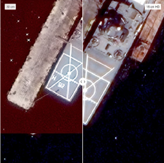
Does HD Really Make Maxar Imagery Better?
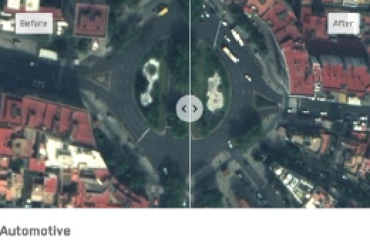
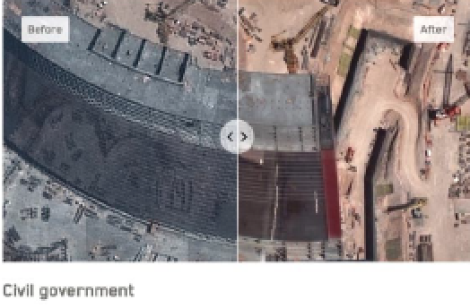
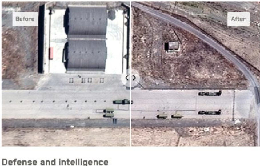
It’s easy to compare a natively collected 30 cm image with its 15 cm HD image to show the improvements. When you see the two images side by side, it becomes clear that the HD image allows the end user to better visualize details and make more informed business decisions.
To quantify the value of HD beyond visual comparisons, the company decided to use machine learning (ML) algorithms to provide an unbiased result. A process of testing HD imagery was started against its natively collected resolution to see if HD will help a feature identification algorithm identify more within the imagery.
Preliminary results have shown that the ML algorithm dramatically increases its average precision of detecting features when run on HD imagery versus the native resolution.
Maxar also leveraged the firm’s GeoHIVE crowdsourcing platform to quantify the value of HD. A broad mix of users were asked to identify light poles, looking at both natively collected imagery along with imagery processed with HD. The GeoHIVE crowd had a 50 percent error rate using the natively collected images; however, after the same imagery was processed with HD, the error rate dropped to 10 percent.
The Best Foundation
HD is an incredibly powerful algorithm that intelligently increases the number of pixels. It is important to understand that we are not changing the natively collected resolution of an image. Instead with HD, we are getting the most quality, value and information from our highest resolution and most accurate satellite constellation.
Maxar’s HD technology provides customers with more options to meet different requirements: Select a native 30 cm image to get the highest resolution 15 cm HD image, or leverage more of Maxar’s native 50 cm imagery with HD processing to have more 30 cm HD imagery available.
HD technology is available for all customers and used to improve the company’s Core Content Strips (System-Ready, View-Ready & Map-Ready) and our Mosaic (Metro, Dynamic & Vivid) basemaps.
Access this direct infolink to learn more about HD...www.maxar.com