
Think “space” and you picture NASA astronauts in puffy spacesuits floating weightless in an orbiting space station. Interesting, perhaps, but of little immediate consequence or value to you.
Think again.
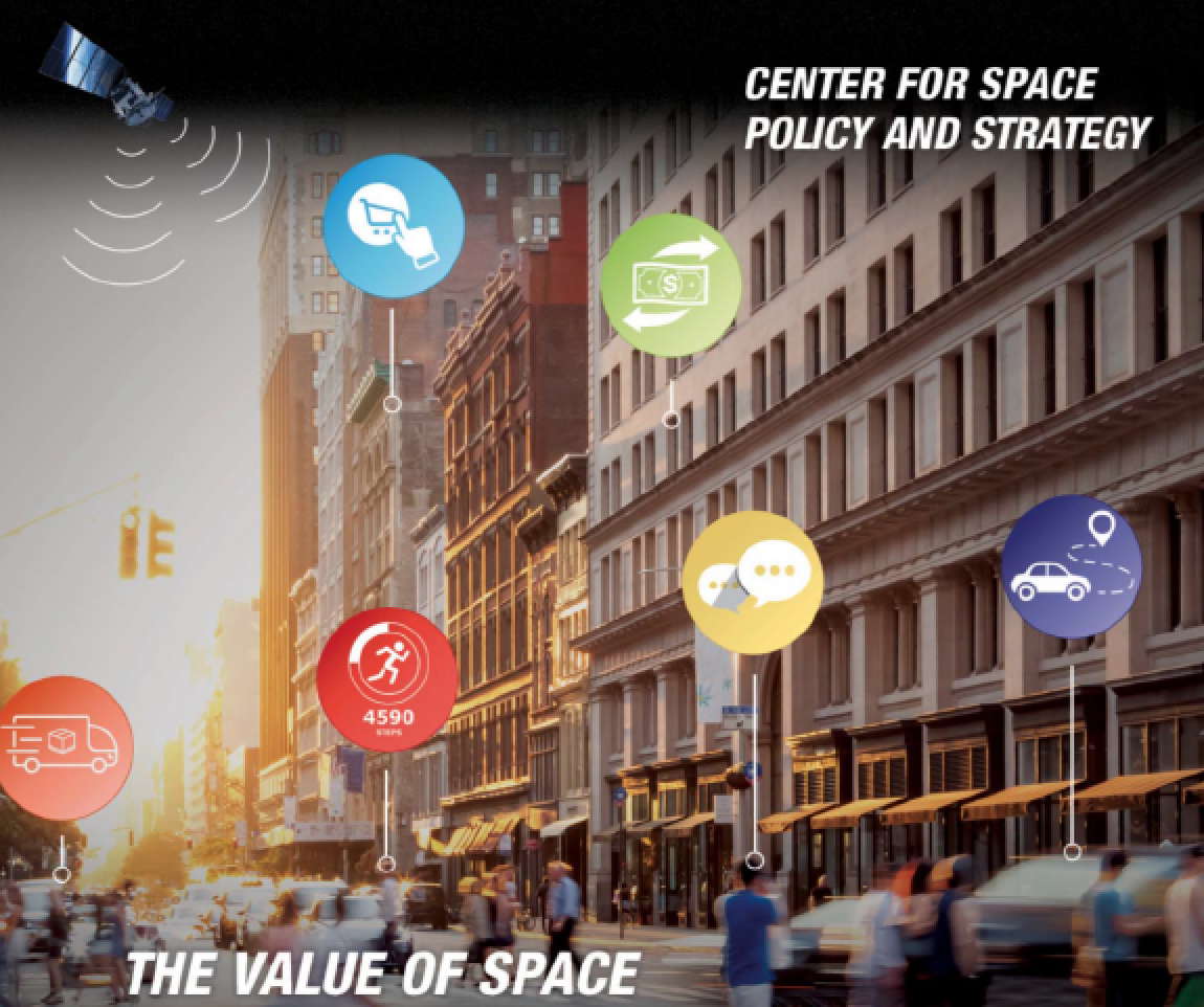
There’s more going on up there than you may realize.The estimated 2,200 active satellites now in space generate immense quantities of data that support Earthly infrastructure, economies, and national security systems.
With the help of space-based services, utility companies synchronize energy flows across the grid, stock market exchanges record transactions, oceanographers track endangered whales, scientists monitor the climate, and farmers increase crop yields. Communications satellites let air traffic controllers manage planes in crowded airspace, remote-sensing satellites reveal what is happening on Earth’s surface in near realtime, and weather satellites give us a better chance of having an umbrella when we need it.

Satellites also allow you to check delivery of the gift you ordered online, reset your home thermostat from the office, talk with family overseas, avoid traffic jams, maybe even find true love.
Introduction
Space-based services have become fundamental to daily life. A June 2019 report estimates that global positioning system (GPS) satellites have generated roughly $1.4 trillion in economic benefits since the system was made available for civilian and commercial use in the 1980s.1 And GPS is just one of many satellite capabilities that give us daily benefits.
The use of space-based services continues to grow as ever more countries and companies launch and operate satellites. More than 50,000 smallsats may be launched by 2030, an impressive jump.2
Society’s use and reliance on space-based assets will only widen and deepen as satellite operators innovate and offer new products and services. Different parts of the economy depend on space-based services to different degrees. The military and emergency management agencies rely on services that are possible only because of satellites.
Although most industries and activities still have backup systems, the cumulative effects of an outage across many interdependent networks and systems would be disruptive as space-based services undergird so much vital infrastructure.
Four kinds of space-based capabilities are commonly used:
1. GPS or similar positioning, navigation, and timing satellites
2. Remote-sensing satellites, which collect data from energy reflected or emitted from Earth
3. Weather satellites
4. Communications satellites
These four categories of satellite capabilities are important for industry and government activity, including in the sectors discussed below. From agriculture to national security, environmental monitoring to finance, commercial fishing to emergency services, space-based services—invisible but invaluable—enable or assist a diversity of everyday applications in ways that we may take for granted.
Agriculture
Agriculture—“our wisest pursuit,” according to Thomas Jefferson—increasingly depends on satellite-based services. Farmers and ranchers use space-based services to monitor crops, observe the condition of fields and pastures, guide tractors and other machinery, and decide when to plant, cultivate, and harvest. They rely on space services to different degrees, but the technology hat underpins modern agriculture would leave Jefferson amazed.
Agriculture was an early beneficiary of weather satellite data, starting in the 1960s. Weather satellites still play an important role in long-range forecasts for agriculture and agri-businesses, along with Doppler radar and local monitoring. Satellite weather data on soil moisture and temperature supports decisions on when to irrigate, move livestock, spray, and harvest.3 One study found that farmers and ranchers with access to satellite TV were more likely to use weather data in making their farming decisions.4 The real value of satellites for agriculture, however, lies in GPS and high-resolution remote sensing—revolutionary tools for managing large fields.
GPS for Field Navigation and Customized Farming
“Precision agriculture” is the efficient use of farm machinery, resources, and time made possible by exact position data.5 Over the past 20 years, satellite services have transformed how farmers deploy equipment. Almost every new tractor and combine sold today come equipped with GPS technology.6
GPS keeps tractors on their intended track, thereby avoiding overlaps that waste seed, herbicide, or fertilizer, as well as skips, which mean an inefficient use of the land. A GPS-equipped tractor could navigate itself within a meter of accuracy, or—with the aid of GPS augmentation technologies—to accuracy within mere centimeters.
Realtime kinematics, for example, use fixed position bases to enhance the accuracy of GPS by correcting positioning errors.7 Some tractors simply notify a farmer when it is out of line by lighting up a monitor, but others have autosteer capabilities: satellite positioning services link directly to the vehicle’s steering mechanism. These virtually hands-free tractors first appeared in the United States in the early 2000s.8
Satellites also enable farmers to assess, at specific locations, the health of the soil and crops, fertilizer needs, and yields. With soil-sampling machinery outfitted with GPS receivers, farmers can analyzesoil at any point on a field. Analysis of soil samplesreveals crop diseases, insect infestations, bare soil, and phosphorus and nitrogen content—all of which determine what treatments the farmer may need to apply.9
Using equipment with GPS receivers, farmers can tailor the application of pesticides or fertilizers to each location. Variable rate technology, as this practice is called, avoids overapplication of pesticides and nutrients.10
The use of satellite-based services for customized farming continues into the harvest. Sensors track yields, and the information is georeferenced using GPS. Farmers can then develop yield maps that show how the harvest varies across their fields. Among other benefits, yield maps provide insight on which approach works best with which soil type.11
Remote Sensing for Field Analyses
Farmers can also assess the health of their cropsusing remote sensing, provided by satellite systems that take images of Earth’s surface. Planet, a commercial satellite company, reports that its images can help farmers monitor crop growth, analyze fields, detect anomalies, optimize inputs and boost yields (Figure 2).12
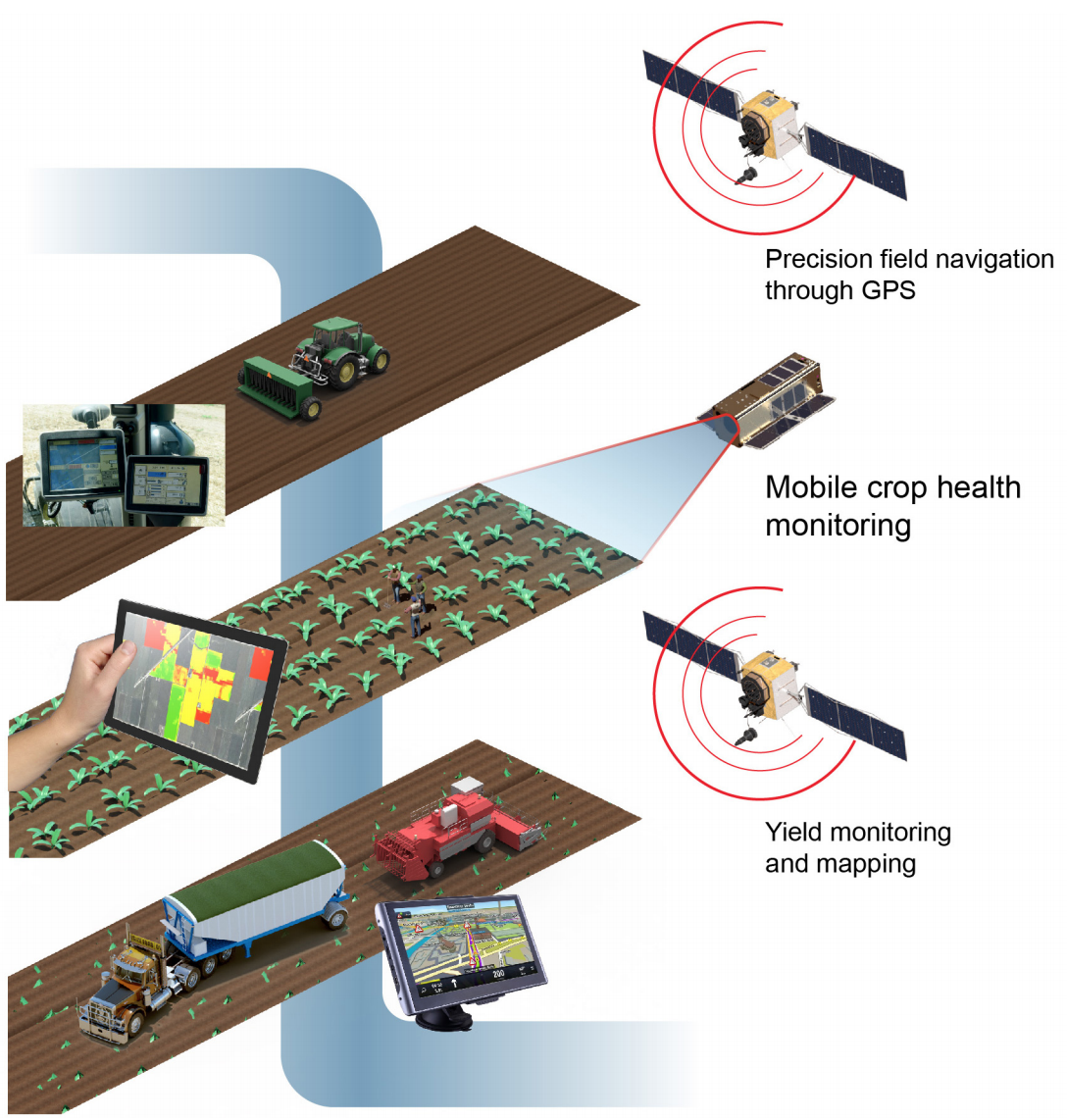 Figure 1. Use of satellite services for agricultural applications.
The data supports diverse customers: digital agriculture companies, which integrate imagery with other field data to boost farm productivity and profitability, as well as governments, nonprofits, universities, and development institutions with public policy goals like food security and famine early warning systems. Farmers often use the images to detect crop damage due to weather, pests, and diseases and to focus fertilizer and pesticide applications where needed.
One way remote sensing satellites assist agriculture is to help determine the level of chlorophyll in the leaves of plants—an indicator of photosynthetic activity and a factor for estimating nitrogen content, plant stress, carbon sequestration, and soil moisture. The information is valuable not just for agriculture but also in environmental research.13 And remote-sensing satellite data can be used to determine elevation, which is particularly helpful in developing countriesthat lack accurate topographical maps and models.14
Usage Data
Precision agriculture was used on less than50 percent of acres planted with corn in 2005 but accounted for more than 72 percent five years later.15
The use of precision agriculture grew significantly from 2001 to 2018, according to the U.S. Department of Agriculture.16 A June 2019 reportfrom the National Institute of Standards and Technology (NIST) estimates that a 30 day outage of GPS during the spring planting season would cause more than $15 billion in losses for the United States, with an average 17 percent loss across six major crops: corn, cotton, peanuts, rice, soybeans, and spring wheat.17
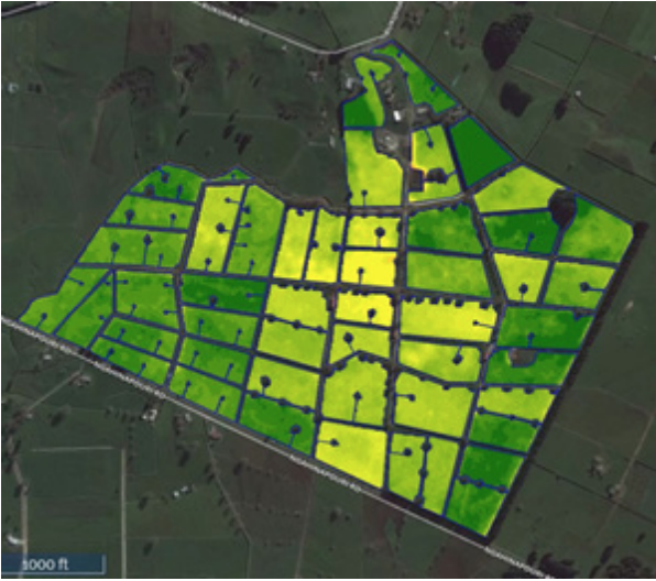
Figure 2: Pastures in New Zealand monitored from space. The dark
green corresponds to rich pasture, and yellow indicates poor pasture.
Image courtesy of Planet Labs, Inc.
Of all the precision agricultural applications, autosteer technology has brought the biggest change and has been adopted most rapidly—“as quickly and as widely as any technology in history.”18 Less widespread are technologies that collect information (yield monitoring, yield mapping, and remote sensing) and practices relying on this information (variable rate technology), likely because the cost of collecting the data is high, and the quantity of data may exceed farmers’ powers of analysis.19
Commercial Fishing and Ocean Monitoring
For commercial fishing and ocean monitoring, all four satellite capabilities are widely used. Weather satellites reduce hazards for the fishing industry; remote sensing services monitor fish stocks; GPS services add accuracy and precision for navigating the seas and placing and retrieving fishing equipment; and communications satellites track marine animal movements and help profile the oceans.20
Satellite Data for Commercial Fishing
Commercial fishermen can subscribe to remotesensing products tailored for the industry. Satellite-based services tailored for fishing offer metrics that—coupled with proprietary algorithms—provide realtime and predictive information for where to find fish.21 Satellites are positioned too high to see fish but can observe oceanographic conditions, such as sea surface temperature and ocean color, that influence fish movements.
This information helps fishermen determine where to place nets and buoys, which can be georeferenced using GPS. Boat captains use GPS to navigate and to broadcast their position to other ships and coastal authorities. Nearly all commercial vessels have GPS antennas.22 Satellite phones are used, given the poor connectivity of cell phones on open waters, and advanced weather services aggregate data from weather satellites, among other sources
Satellites are also used to keep commercial fishermen within permitted parameters. At night in clear weather, U.S. weather satellites can detect fishing vessel lights. The data are used to help enforce national fishing boundaries. When lights are detected in a protected zone, for example, authorities can efficiently deploy aircraft or ships to investigate; no longer must they constantly patrol vast areas of ocean.23
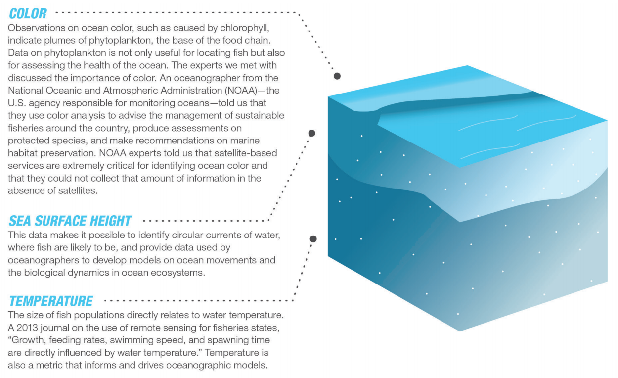 Figure 3. Ocean data from space.
Remote Sensing for Ocean Monitoring
Data on ocean color, height, and temperature helpscientists monitor oceanographic conditions and develop strategies for sustainable fisheries management (Figure 3).24
Satellites are now integral to what oceanographers do. An oceanographer at the Pacific Marine Environmental Laboratory said, “They give us a whole picture of what is going on in the ocean.”25
Scientists depend on satellites for collecting data because it would be extremely costly to cover extensive, remote waters with buoys and ships. For assessing ocean color, oceanographers use U.S. and U.S. partners’ satellite systems, including polar orbiting satellites and sensors.
Satellites for Animal Tagging
Using both GPS and communications satellites, the National Oceanic and Atmospheric Administration (NOAA) tracks and collects information on fish, birds, seals, and whales.26
Location transmitters and sensors on sea turtles, salmon, or birds relay information about the animals’ movements to inform behavioral studies. The information allows NOAA to issue advisories to help vessels avoid endangered whales and sea turtles during migrations.27

The tags on the animals collect information on ocean temperatures and other metrics as well. Without GPS and communicationssatellites, scientists would need to rely on drifting float systems that would not have comparable geographical breadth.
NOAA also collects information on oceans and marine animals withsail drones.28 Sail drones collect oceanic surface, subsurface, and atmospheric measurements and acoustic signatures of marine mammals. The sail drones then transmit information to communications satellites that in turn relay the data to scientists for analysis.29 Figure 4 on the following article page shows ocean monitoring and commercial fishing applications aided by satellites.
Environmental Monitoring
Satellite services help monitor and predict weather as well as changes to the Earth’s climate, surface, and atmosphere.
Weather Forecasting
Accurate weather forecasts allow national, state, and local governments to prepare for disasters, manage and maintain services, and protect lives, property, infrastructure, and natural resources. They enable commercial enterprises to protect supply chains, plan for production, and reduce risk. And, of course, they help all of us plan our daily activities.
Starting in the 1960s, weather satellites vastly improved weather forecasting, with benefits for air transport, shipping, construction, and utilities. The unreliable three-day forecasts of the pre-satellite era have given way to much more accurate 10-day forecasts.
Warnings for tornadoes, flash flooding, and other extreme events are now issued earlier and are more precise about severity and location. Satellite observations even make it possible to predict the track of a hurricane five days out, and better forecasting has produced a big drop in the loss of life from hurricanes.30
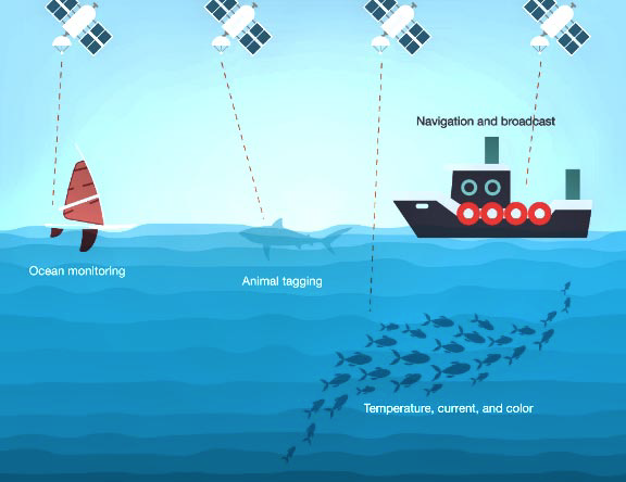
Figure 4. Ocean monitoring and commercial fishing applications
aided by satellites.
Forecasters around the world share space-based meteorological data from remote sensing and weather satellites through the World Meteorological Organization. More than 3,000 weather forecast outlets across the 185-member countries and 6territories rely on the space-based data it distributes.31
In the United States, NOAA weather satellites collect the most meteorological data (Figure 5). The large-scale weather and climate data from satellite observations are often refined byweather instruments at the surface, such as Doppler radar towers, weather stations, aerial balloons, and ocean buoys.32
Ground-based instruments allow continuous monitoring of local environmental conditions and cover areas where satellite imaging cannot penetrate clouds; however, they cannot cover extensive territory, especially remote areas like open ocean and polar regions. Each day the National Weather Service receives about 2,700 observations from ships, 18,000 from weather buoys, 115,000 from aircraft, 192,000 from surface stations, and 250,000 from balloons—impressive, yet far fewer than the 140 million daily observations it obtains from satellites.33
New satellite technologies will improve the accuracy and reliability of weather forecasting even more. These include space-based synthetic aperture radar, light detection and ranging radar (LIDAR), and GPS signals passing through the atmosphere. For example, a satellite-borne LIDAR could better measure winds over the oceans, where coverage currently is patchy, to pinpoint developinghurricanes and typhoons.34
Pollution and Climate Assessments
Satellites help scientists monitor long-term changes in Earth’s climate and environment, includingpollution and deforestation. State and local jurisdictions are beginning to rely more on satellite capabilities than ground-based measurements for environmental monitoring. Florida, for example, is using remote sensing data to measure pollution levels in the state’s coastal waters.35
In some cases, the resolution of imagery from satellites has outpaced that of ground-based measurement instruments. For example, because of inaccuracies in ground-based monitors of air pollution, the U.S. Environmental Protection Agency has misclassified the air quality of areas representing more than 24.4 million residents;according to one analysis, the errors have contributed to at least 5,000 premature deaths.36
Both NASA and the European Union use satellitesto measure polar ice melt and rising sea levels.37 Satellites provide a reliable means to collect long-term data over large stretches of Earth to monitor climate change.
Emergency Services
In a disaster, whether natural or human caused, space-based services become critical for saving lives and protecting property. For emergency response, GPS, remote sensing, weather satellites, and satellite communications are all widely used.
Weather Alerts
The best way to mitigate a disaster is to avoid it, and weather alerts allow people to do just that. Satellites contribute to every step in the process. They help identify the weather events, including forest fires.
For example, thermal imaging systems on defense satellites can be used to detect forest fires started by lightning strikes. Once the data is obtained and analyzed, it needs to be disseminated so that people receive timely warnings.
The National Weather Service, in partnership with the Federal Communications Commission, issues severe weather alerts and warnings across the United States via television and radio, which employ satellite signals and direct-broadcast satellite systems.38
These warnings include alerts for tornados, hurricanes, floods, thunderstorms, volcanic eruption, and drought. Third-party weather providers and local governments then use mobile communications systems to further disseminate alerts to mobile phones, which give citizens time to protect their property and evacuate.
Communications
If terrestrial communication services go down, space-based services provide an alternative. Unlike terrestrial services, satellites provide global coverage and are physically isolated from the disaster; satellite communications signals are thus available even in remote areas when normal telecommunications services are disrupted.
Using satellite broadband transceivers, satellite messengers, and GPS-enabled rapid deployment kits, first responders can direct rescue operations, request humanitarian relief supplies, communicate with authorities, and coordinate the influx of arriving aid.
Damage Assessment
In addition to the value of communications satellites during emergencies, remote sensing satellites provide detailed information on the condition of infrastructure such as roads, bridges, ports, utilities, and buildings within hours or minutes of an event.
If ground-based communications are down, rescue and recovery personnel use remote sensing imagery to direct rescuers and emergency resources to the areas that need help the most. Remote sensing information also informs decisions about the most efficient ways to reach the disaster area: If roads are blocked and bridges are out, rescuers can send helicopters and not waste precious time trying to approach the area by road.
Location and Navigation
GPS is heavily used for a variety of lifesaving activities, like navigating through traffic to a house fire or car crash. GPS services help emergency responders determine the precise location of a person in distress and route personnel as quickly as possible. Vehicles and ships can send out distress signals that satellites detect; even hikers can use satellite messengers or GPS-enabled smartphones. Space-based search-and-rescue servicescan pinpoint a distress signal’s location, however remote, and send it to emergency responders in seconds.39
Distress beacons may connect to different types of satellites—from dedicated search-and-rescue satellites (SARSAT) and communications satellites to navigation satellites like GPS and even weather satellites.40 GPS and space-based rescue beacon relays have taken the “search” out of search and rescue, saving critical resources, time, and lives. Indeed, space-based search-and-rescue services are credited with facilitating more than 41,000 rescues worldwide since 1982 (Figure 6).41
Power Grid
Satellite services improve the efficiency of the electric power grid. The timing signal from GPS has the greatest benefit: Power plant operators use it to monitor the performance of the grid down to the nanosecond to help prevent equipment and power failures.42
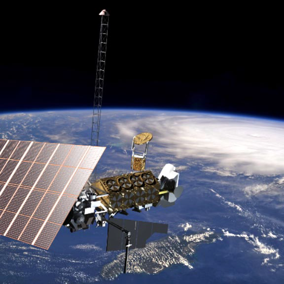 Figure 5. Artistic rendition of a weather satellite monitoring a hurricane.
Although the grid has built-in backup features that would facilitate operations for several days in the absence of GPS, the satellite constellation is the primary source of precision timing.The grid also uses satellite communicationsfor the supervisory control and data acquisition system.
GPS for Precision Timing
Electric power for the grid comes from many sources, necessitating continuous measurement of current and voltage with corresponding time stamps. Federal standards require these time stamps to be accurate within nanoseconds.43
Prior to GPS, the timing was much less precise: The industry would monitor the grid only every two-to-five seconds. The time-synchronized
measurements enabled by GPS protect the power system by maintaininggenerator, frequency, and voltage control and ensuring continuity even when a generator goes down. One expert stated that with GPS, “it’s safe to say that all utilities, be it generation, transmission, or distribution, will use spaced-based timing.”
A 30-day outage of GPS would not likely cause a major disruption of the electrical system because of existing safeguards and contingency plans, but it might increase the probability of outages and make it difficult to pinpoint their cause.44
Weather Satellites to Predict Flow and Demand
Every grid control room, one expert observes, keeps The Weather Channel on. Weather analysis helps operators anticipate changes in the power grid’s functions, including extra demand for air-conditioning, variable supply from solar generators, and potential disruptions from lightning (which can cause voltage spikes in transmission lines) or ice storms.
Operators monitor the weather—temperature, wind, sunlight, storms—both for immediate action and to prepare for the next day. The weather inputs tell them whether to reroute power or take generators online or offline. In extreme conditions, they can turn off circuit breakers or enable other grid sources, taking protective or remedial actions to stabilize the grid.
Operators also consider weather conditions to develop models for managing generation. Wind and solar power generation requires predictive models that estimate how much energy these alternative sources will produce.45
Operators tend to focus on weather information from stationary sensors for realtime data rather than weather satellites, but they rely more on the satellites for forecasting future weather conditions, such as storms that will affect the service area.
Yet to Come: Grid Use of Communications and Weather Satellites
In the future, weather data could inform autonomous decision making. For example, grid operations could be programmed to respond to data from satellites, turning off circuit breakers or bringing generators on line as needed. Proposed large commercial communications constellations could also offer machine-to-machine communications applications in the power sector.46
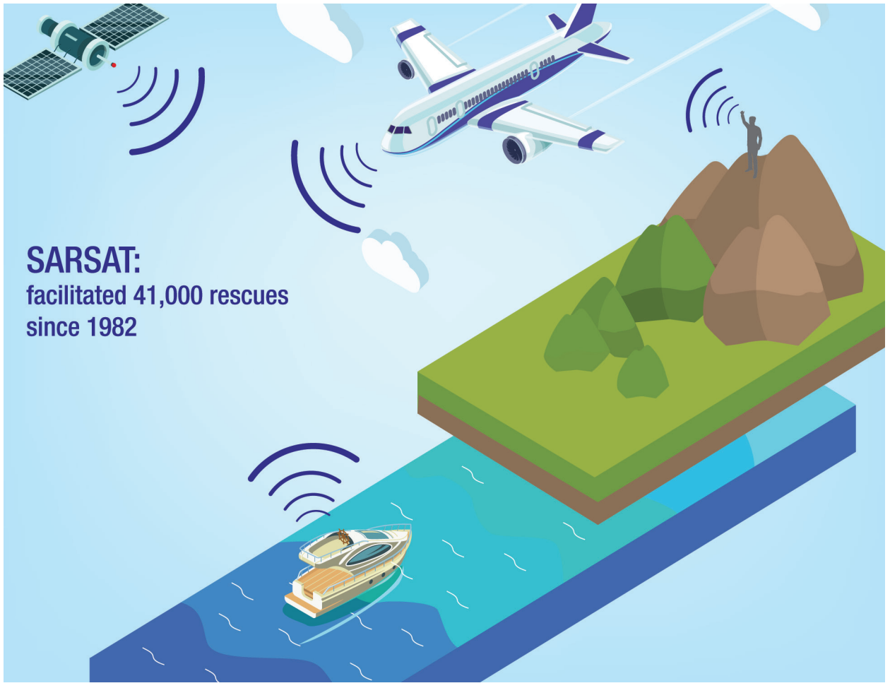
Figure 6: GPS and space-based rescue beacon relays.
Business, Trade, and Finance
The global economy relies on space systems for a broad range of foundational activities. For example, satellite communications and GPS services support global supply chain management, efficient air travel, and the operationsof multinational corporations. The development of space-based infrastructure has fostered globalization since the 1960s, and its progression will continue to affect the world economy in the decades to come.
Trade and Transportation
For global shipping, three space-based services—GPS, remote sensing, and communications—complement and often substitute for terrestrial infrastructure, improving efficiency and ensuring reliable and secure communications platforms.
For example, maritime shipping companies and 11operators use satellite communications and navigation to manage their fleets, monitor ships’performance, optimize transportation routes, and transfer data while en route. Containerized processing, which has revolutionized the shipping industry, relies on accurate tracking of ships and individual containers, made possible by satellite navigation aids and transponders that relay information via satellites.47 Remote sensing enables long-term monitoring of both global trade activityand local inventories, such as crude oil storage.48
For safety, the International Maritime Organization requires vessels of more than 300 gross tonnage on international voyages, as well as passenger ships, to be outfitted with a global marine distress and safety system, which integrates satellite and terrestrial radio communications.49 The system alerts nearby ships as well as search-and-rescue organizations,such as the U.S. Coast Guard, to the vessel’s status in case of emergency.
Air transportation networks also use satellite communications and navigation to improve safety, efficiency, and capacity. Accurate navigation reduces fuel consumption, aircraft engine emissions, and overall costs.50 The volume and pace of operations at airports have increased substantially thanks to coordinated sequencing of navigation satellites, allowing millions of travelers to arrive at their destinations earlier and saving airlines hundreds of thousands of dollars per year.51 Pilots, passengers, and air traffic controllers use satellite communications to maintain communication with the ground and access the Internet in flight far beyond the range of terrestrial services. Such safety-of-life applications are some of the greatest benefits yielded by satellites in aviation.
GPS and communication networks also improve the efficiency, capacity, and safety of rail and road transportation, again reducing fuel consumption, emissions, and costs. For example, just as with maritime shipping, container tracking uses a combination of GPS receivers and communications satellites to relay the position of goods along transportation corridors, enabling just-in-time delivery and precise inventory control (see Figure 7).
Banking and Finance
GPS has many applications for global finance and banking. Exchanges, trading houses, and other actors in the financial services sector use GPS and other space-based location and timing systems to facilitate accurate time-stamping of financial transactions.52
Space-based systems are costeffective, secure, and convenient,though terrestrial backups (such as networked atomic clocks) are still on hand in case of a signal disruption.53
Each day, hundreds of thousands of international currency trades are made at incredibly high speeds, with an estimated daily value that exceeds $5 trillion. If governmental regulatory systems and trader clocks used different methods or units to measure the time, both parties’ records could fall out of sync with each other. Without a clearly documented order of market events available for oversight, regulators would struggle to detect abuses of the system, such as spoofing and other illegal practices.54
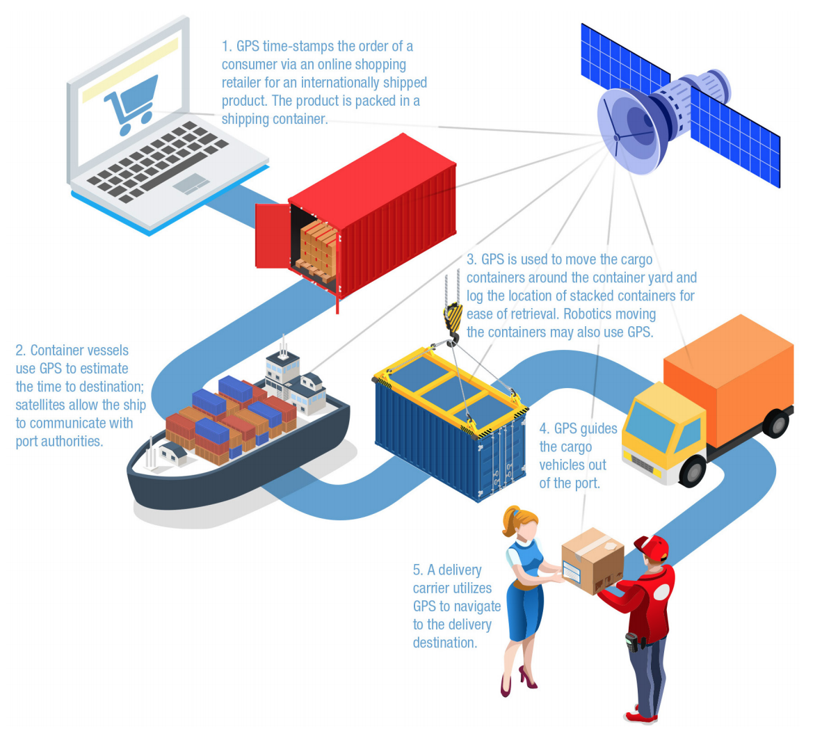 Figure 7: Use of GPS for product shipping and delivery.
As financial markets continue to globalize, high-frequency trading will necessitate use of algorithms where transactions are verified and time-stamped via GPS timing signals.55
The mobile apps for banking and financial services available for smartphones use the same highly precise time-stamping that facilitates high-frequency trading on Wall Street. Where connectivity is limited and populations are sparse(for example, in Alaska), satellite communication networks in tandem with space-enabled Internet and other connectivity tools have allowed banks and other financial institutions to offer services without a brick-and-mortar presence.
Across the globe, mobile banking applications have combined with satellite Internet technologies to expand financial participation to historically unbanked and remote populations in developing countries.56
Satellite location-based services and end-user apps for consumers have exploded since the adoption of the smartphone, from mobile ridesharing apps such as Uber and Lyft to same-day, just-in-time delivery services like Postmates. Although GPS is most commonly associated with traffic and map apps forsmartphones and cars, space-based positioning, navigation, and timing services underpin many other modern consumer services, from online shopping and small businesses’ supply chains to communities’ economic development.
National Security
The U.S. military and the intelligence community use space-based services for many critical national security activities that would be difficult or impossible without satellites. The 2017 National Security Strategy states, “The United States considers unfettered access to and freedom to operate in space to be a vital interest” to the security of the United States.57
The military and intelligence community own and operate dedicated fleets of satellites and supporting ground-based infrastructure and networks to meet their specialized needs, such as detecting ballistic missile launches. They also lease or buy space services, especially satellite communications, from the commercial space sector and use U.S. government civilian space capabilities, such as weather information from NOAA’s weather satellites.
The value of space to the national security sector is both wide and deep: wide, in that all military services use space-based applications all over the world every minute of every day, and deep, in that space services are embedded in national security infrastructure, programs, equipment, and operationsfrom top to bottom.
For example, the president would use satellite communications to direct U.S. nuclear forces through the nuclear command-and-control system; senior joint force commanders use satellite communications to direct forces in the field down to the platoon level; and soldiers and seamenuse GPS to navigate.
Most critically, military use of space-based services saves lives by reducing accidental civilian causalities and enabling battles to be won more quickly, as well as facilitating search-and-rescue activities and delivery of humanitarian aid and disaster relief. The precision enabled by GPS, the awareness provided by space-based remote sensing, and the command-and-control capabilities of satellite communications have become fundamental to the modern American military.
National security space capabilities support joint functions, which are “related capabilities and activities grouped together to help Joint Force Commanders integrate, synchronize, and direct joint operations.”58
The U.S. military has identified seven joint functions (command and control, intelligence, fires (precision strike), movement and maneuver, protection, sustainment, and information) to organize thinking about military operations.
Command and Control
Dedicated intelligence and military space assets provide strategic, operational, and tactical information to everyone from the commander-in-chief down to the platoon leader, pilot, or ship captain. Timely, high-quality data from satellites enables leaders to make critical operational decisions, and military networks use space-based timing signals to synchronize activities.
For example, specialized missile launch warning satellites, which detect the infrared (heat) signature produced by a rocket launch, provide advance noticebefore a missile hits U.S. or allied forces, allowingtime to react, intercept the incoming warhead, and enable counterattack by tracing the enemy missile back to its launch site.
Commanders also use information from weather satellites to monitor the operational conditions in their area of responsibility, help decide when to launch operations, and equip fighters with proper gear. Satellite communications connect leaders to field forces, allowing them to exchange information and deliver orders quickly and securely anywhere in the world. In addition, these capabilities support friendly force tracking, which alerts commanders to the location and status of their allies.
Intelligence
Intelligence information from space gives a decisionmaker, whether strategic or tactical, timelyand accurate information for tracking adversary activities, capabilities, and deployments, from which the enemy’s intentions can be deduced. The information helps deter conflict, but, if deterrence fails, it helps the military see through the fog of war.
Precision Strike
GPS services enable precise targeting of weapons, often within three feet. The delivery platforms (aircraft, ships, artillery, and rockets) have embedded GPS that place them in relation to an enemy target. The weapons themselves also have GPS receivers to improve the final targeting. It’s hard to think of a modern weapons system without GPS.
Movement and Maneuver
Space-based services are critical for deploying U.S. forces around the world and maneuvering them in battle. Satellites enable mobile communication among aircraft, ships, and vehicles, both manned and unmanned. GPS enables precise positioning and navigation, and weather satellites help inform decisions on deploying and maneuvering forces. Friendly force tracking, enabled by a combination of GPS and communication satellites, givescommanders constant, high-fidelity information on the location of U.S. forces. This combination enables a high operations tempo and maximizes commanders’ ability to deploy forces efficiently.
Protection
Commanders must protect personnel, equipment, facilities, infrastructure, and information from physical attack, cyberattack, and sabotage. Space-based services support this function in several ways.
First, missile warning satellites provide early noticeof missile attack.
Second, space-based intelligence, surveillance, and reconnaissance information alerts commanders to emerging threats.
Finally, space-based weather information enables warning and protection measures against hurricanes, sand storms, and other natural threats.
Sustainment
Similar to the global shipping industry, GPS also supports global military operations and the huge, complex logistical challenges that come with it. GPS enables the military to track and deliver the right supplies to the right place at the right time. Likewise, satellite communications enable widely dispersed forces to stay connected to their supply chains and convey any changes in logistic requirements. And space-based surveillance and weather services facilitate route planning and timing, and help commanders decide whether supplies should be air-dropped or brought in by truck or ship
Information
The military at all levels relies upon timely, assured information. Space-based weather, remote sensing, and GPS information is now integral to each of the other six joint functions. In fact, space-based services permeate every core function of the modern military and have contributed greatly to U.S. military engagements since the 1991 Gulf War.
On the Horizon
Space-based services already support our daily lives, but there is more to come. Just as it was difficult to foresee the myriad uses of GPS in the late 1980s, it’s hard to imagine how this fresh flood of commercial space data will affect the economy, the military, and daily life.
For the military, fighters in the field may directly receive remote sensing imagery from commercial as well as military and intelligence satellites. The military is also investigating how commercial communications networks—coupled with Earth imaging satellites, missile warning networks, and space-based position, navigation, and timingconstellations—can increase the amount of transmitted information while improving military connectivity and speed.
Some of the planned commercial satellite constellations will offer communications capabilities for space-based broadband Internet connectivity, support 5G (the fifth-generation wireless technology), and enable machine-to-machine communication for interconnected devices in the Internet of Things.
Current satellite capabilities will also be leveraged for new or underused applications. For example, satellites can transmit large quantities of precision data, but it’s too much information for farmers to use for decisionmaking. If one could pool the data being collected from thousands of farms—data for soil sampling, yield monitoring, yield mapping, use of fertilizer and pesticides—and apply machine-learning algorithms, farmers could better determine how to increase yields.
Business models that couldincentivize aggregation of this data could produce huge benefits. Many nascent technologies will increasingly use GPS:59
• 5G and next-generation networks
• Internet of Things (IoT)
• Autonomous vehicles on land and sea and in the air
• Robotics
• Next-generation air traffic control
• Vehicle usage and toll metering
• Smart intersections
Conclusion
Whether the topic is mega-constellations of satellites, rockets that can be reused, space tourism, the Space Force, threats to space operations, exploring the moon or Mars, space debris, the status of Pluto, or space-themed movies, space activities have generated lots of press and recaptured the national consciousness.
In this frenzy of technological change and policy debate, it is important to remember the immense value that space provides. Space-based communications, navigation, weather, and remote sensing services make our daily lives better, and contribute to saving lives and property. Consumers enjoy the benefits of satellite services, usually without realizing their source; governments and businesses use space services for high-stakes purposes.
For all of us, satellites have become integrated into 21st-century society, much as electricity and mass communications became integral to 20th-century modernity. Next time you think about space, think about that.
Acknowledgments
This paper benefited from a diversity of inputs and contributions. James Vedda, Russell Rumbaugh, Colleen Stover, Marlon Sorge, David Tralli, John Hackwell, and Scott Van Dyke provided thorough and insightful reviews, and Jacob Bain developed compelling graphics. Thanks also to Sally Atwater and Nina Isaia for their valuable input and edits, which made the paper more elegant, and to the dozens of people interviewed for the paper.
References
1Alan C. O’Connor, Michael P. Gallaher, Kyle Clark-Sutton, Daniel Lapidus, Zack T. Oliver, et al., “Economic Benefits of the Global Positioning System (GPS)” (National Institute of Standards and Technology, June 2019), ES-1, https://www.rti.org/sites/default/files/gps_finalreport.pdf?utm_campaign=SSES_SSES_ALL_Aware2019&utm_source=Press%20Release&utm_medium=Website&utm_content=GPSreport (hereafter “NIST 2019”).
2Dave Mosher, “Watch 57,000 planned satellites swarm Earth within 9 years in a stunning new animation,” Business Insider, February 1, 2020, https://www.businessinsider.com/animation-internet-satellites-surrounding-earth-starlink-kuiper-oneweb-agi-2020-1 Glenn Peterson, Marlon Sorge, and William Ailor, “Space Traffic Management in the Age of New Space” (The Aerospace Corporation, April 2018), https://aerospace.org/paper/space-traffic-management-age-new-space.
3George B. Frisvold and Anand Murugesan, “Use of Weather Information for Agricultural Decision Making,” Weather, Climate, and Society, January 23, 2013, https://journals.ametsoc.org/doi/full/10.1175/WCAS-D-12-00022.1.
4Ibid.
5NIST 2019, 67.
6NIST 2019, 74.
7RTK Farming, “About RTK,” http://www.rtkfarming.co.uk/about-rtk/, accessed on July 12, 2019.
8J. Lowenberg-DeBoer, “The Precision Agriculture Revolution,” Foreign Affairs, May-June 2015, https://www.foreignaffairs.com/articles/united-states/2015-04-20/precision-agriculture-revolution. NASA Technology Transfer Program, “GPS Correction Technology Lets Tractors Drive Themselves,” https://spinoff.nasa.gov/Spinoff2017/ee_1.html, accessed July 12, 2019.
9Carl Crozier and Ron Heiniger, “Soil Sampling for Precision Farming Systems,” NC State Extension Publications, March 9, 2015, https://content.ces.ncsu.edu/soil-sampling-for-precision-farming-systems.
10Lowenberg-DeBoer, “The Precision Agriculture Revolution.”
11Ibid.
12Personal communication, Zara Khan, Planet Labs, July 17, 2019.
13Shashikant Tripathi et al., “Calculating carbon sequestration using remote sensing and GIS,” Geospatial World, May 3, 2010, https://www.geospatialworld.net/article/calculating-carbon-sequestration-using-remote-sensing-and-gis/; Arturo Reyes-Gonzalez et al., “Estimation of Crop Evapotranspiration Using Satellite Remote Sensing-Based Vegetation Index,” Advances in Meteorology,February 1, 2018, https://www.hindawi.com/journals/amete/2018/4525021/abs/; Facundo Carmona, Raul Rivas, and Diana C. Fonnegra, “Vegetation Index to Estimate Chlorophyll Content from Multispectral Remote Sensing Data,” European Journal of Remote Sensing, February 17, 2017, https://www.tandfonline.com/doi/pdf/10.5721/EuJRS20154818; Wolhlfart et al. “Sun-induced fluorescence and gross primary productivity during a heat wave,” Nature, September 21, 2018, https://www.nature.com/articles/s41598-018-32602-z.
14Personal communication, David Mulla, professor, University of Minnesota, June 24, 2019. Drones also collect images for precision agriculture and are typically preferred for high-value crops, like wine groups. Drones offer more detailed imagery than satellites; however, drone imagery is more expensive because drones cover less area. Matese et al. “Intercomparison of UAV, Aircraft and Satellite Remote Sensing Platforms for Precision Viticulture,” Remote Sens. 2015, 7, 2971-2990; doi:10.3390/rs70302971.
15U.S. Department of Agriculture, Economic Research Service, “Crop production practices,” Reports for Precision Agriculture, https://data.ers.usda.gov/reports.aspx?ID=17883, accessed on July 12, 2019.
16U.S. Department of Agriculture, Economic Research Service. “Crop production practices.” Reports for Precision Agriculture. Accessed on July 12, 2019. https://data.ers.usda.gov/reports.aspx?ID=17883
17NIST 2019, 72.
18Lowenberg-DeBoer and Erikson, 2019.
19Lowenberg-DeBoer and Erikson, 2019.
20NIST 2019, 139.
21Maxar, Radiant Solutions, https://www.radiantsolutions.com/capabilities, accessed on July 26, 2019.
22NIST 2019, 139.
23Samantha Emmert, “Identification of ‘Dark Vessels,’” Global Fishing Watch, June 8, 2018, https://globalfishingwatch.org/research/viirs/; Michael Carlowicz, “Something Fishy in the Atlantic Night,” NASA, October 22, 2013, https://earthobservatory.nasa.gov/features/Malvinas; Yvette Sierra Praeli (trans. Romina Castagnino), “Peru Shares Its Fisheries Surveillance Data with the World,” Mongabay, November 16, 2018,https://news.mongabay.com/2018/11/peru-shares-its-fisheries-surveillance-data-with-the-world/.
24Victor Klemas, “Fisheries Applications of Remote Sensing: An Overview,”Fisheries Research, November 2013, https://www.sciencedirect.com/science/article/pii/S0165783612001075; Michael J. Behrenfeld et al. “Carbon-Based Ocean Productivity and Phytoplankton Physiology from Space,” Global Biogeochemical Cycles, January 25, 2005, https://agupubs.onlinelibrary.wiley.com/doi/full/10.1029/2004GB002299.
25Personal communication, Phyllis Stabeno, oceanographer, Pacific Marine Environmental Laboratory, July 12, 2019
26Aaron Cyr and Silke Nebel, “Satellite and Data Logger Telemetry of Marine Veterbrates,” Nature, 2013, https://www.nature.com/scitable/knowledge/library/satellite-and-data-logger-telemetry-of-marine-96643712.
27Personal communication, Michael Ford, National Oceanic and Atmospheric Administration, July 30, 2019
28“Saildrone,” National Oceanic and Atmospheric Administration, Pacific Marine Environmental Laboratory, https://www.pmel.noaa.gov/ocs/saildrone, accessed July 23, 2019.
29 ersonal communication, Robert Foy, director, Alaska Fisheries Center, June 23, 2019.
30National Oceanic and Atmospheric Administration, “Building a Weather-Ready Nation,” May 2016, https://www.noaa.gov/explainers/improving-weather-forecasts; Frank Decatur Marks et al, “Hurrican Forecasting: The State of the Art,” Natural Hazards Review, July 2005.
31Space Security Index, 2018, http://spacesecurityindex.org/2018/10/space-security-2018/
32https://www.weather.gov/rah/virtualtourmetdata.
33Tim Brookes, “How’s the Weather Out There? Forecasting the Chaos of Weather,” National Geographic, June 21, 2019, https://www.nationalgeographic.com/environment/natural-disasters/weather-forecasting/.
34Ibid.
35Yusuke Kuwayama and Bethany Mabee, “How Do We Measure the Value of Satellite Data?” Resources, Winter 2017, https://www.resourcesmag.org/archives/how-do-we-measure-the-value-of-satellite-data/.
36Daniel Sullivan and Alan Krupnick, “Using Satellite Data to Fill the Gaps in the US Air Pollution Monitoring Network,” September 12, 2018, https://www.rff.org/publications/working-papers/using-satellite-data-to-fill-the-gaps-in-the-us-air-pollution-monitoring-network/.
37National Aeronautics and Space Administration, Goddard Space Flight Center, “ICESat & ICESat-2,” https://icesat.gsfc.nasa.gov/
38National Oceanic and Atmospheric Administration, “Factsheet: NOAA’s National Weather Service (NWS) and the Emergency Alert System,” https://www.nws.noaa.gov/nwr/resources/EAS_factsheet.pdf.
39Olaf Acker, Florian Potscher, and Thierry Lefort, “Why Satellites Matter,” Report Booz & Company, September 2012. https://www.esoa.net/Resources/Why-Satellites-Matter-Full-Report.pdf.
40National Oceanic and Atmospheric Administration, “Search and Rescue Satellites,” https://www.sarsat.noaa.gov/satellites1.html.
41National Oceanic and Atmospheric Administration, “NOAA Satellites Aid in the Rescue of 275 Lives in 2017,” February 8, 2018, https://www.noaa.gov/media-release/noaa-satellites-aid-in-rescue-of-275-lives-in-2017.
42U.S. Department of Energy, Office of Electricity, “Synchrophasor Applications in Transmission Systems,” https://www.smartgrid.gov/recovery_act/program_impacts/applications_synchrophasor_technology.html,and “April 2019 Global Positioning System (GPS) Week Number Rollover,” April 2019, https://www.energy.gov/oe/articles/april-2019-global-positioning-system-gps-week-number-rollover; Dominic Saebeller, “How Much Will It Cost to Protect America’s Electrical Grid? Who Will Pay?” Defense One, May 8, 2019, https://www.defenseone.com/ideas/2019/05/how-much-will-it-cost-protect-electrical-grid-and-who-will-pay/156834/?oref=d1-related-article; Joseph Marks, “Pentagon Researchers Test ‘Worst-Case Scenario’ Attack on US Power Grid,” Defense One, 18, November 14, 2018, https://www.defenseone.com/technology/2018/11/pentagon-researchers-test-worst-case-scenario-attack-us-power-grid/152829/?oref=d1-related-article; Amy Myers Jaffe, “How the Climate Crisis Threatens the US Energy System,” Defense One, June 16, 2019, https://www.defenseone.com/threats/2019/06/how-climate-crisis-threatens-us-energy-system/157755/?oref=defenseone_today_nl.
43North American Electricity Reliability Corporation, “Disturbance Monitoring and Reporting Requirements,” PRC-002-2, https://www.nerc.com/_layouts/15/PrintStandard.aspx?standardnumber=PRC-002-2&title=Disturbance%20Monitoring%20and%20Reporting%20Requirements&jurisdiction=United%20States, accessed on July 24, 2019, and “Disturbance Monitoring Equipment Installation and Data Reporting,” PRC-018-1, https://www.nerc.com/_layouts/15/PrintStandard.aspx?standardnumber=PRC-018-1&title=Disturbance%20Monitoring%20Equipment%20Installation%20and%20Data%20Reporting&jurisdiction=United%20States, accessed on July 24, 2019.
44NIST 2019, 77.
45Can Wan et al., “Photovoltaic and Solar Power Forecasting for Smart Grid Energy Management,” CSEE Journal of Power and Energy Systems,December 2015, https://ieeexplore.ieee.org/stamp/stamp.jsp?arnumber=7377167.
46Alessio Meloni and Luigi Atzori, “The Role of Satellite Communications in the Smart Grid,” IIEE Wireless Communications, April 2017, https://dl.acm.org/citation.cfm?id=3095441.
47Marc Levinson, The Box: How the Shipping Container Made the World Smaller and the World Economy Bigger, (Princeton, NJ: Princeton University Press, 2006), https://doi.org/10.1017/S1467222700008703.
48Orbital Insight, “Understanding Global Oil Storage Trends through Geospatial Analytics,” Report, https://orbitalinsight.com/understanding-global-oil-storage-trends-geospatial-analytics/.
49International Maritime Organization, “Our Work: Martime Safety,” http://www.imo.org/en/OurWork/Safety/Pages/Default.aspx; NIST 2019, 130.
50Aieron Corporation, “Global Air Traffic Surveillance,” https://aireon.com/services/global-air-traffic-surveillance/, accessed June 2, 2019.
51Federal Aviation Administration, “How NextGen Works: Data Comm,” https://www.faa.gov/nextgen/how_nextgen_works/new_technology/data_comm/.
52UK Government, Office for Science, “Satellite-Derived Time and Position: A Study of Critical Dependencies,” https://assets.publishing.service.gov.uk/government/uploads/system/uploads/attachment_data/file/676675/satellite-derived-time-and-position-blackett-review.pdf, accessed June 15, 2019.
53U.S. Air Force, “Applications: Timing,” https://www.gps.gov/applications/timing/, accessed 28 June 2019.
54Bradley Hope, “Clock Synchronization with Traders Is Challenge for Regulators,” Wall Street Journal, July 14, 2014, https://www.wsj.com/articles/regulators-traders-are-out-of-sync-1405295799.
55Bank for International Settlements, “High-Frequency Trading in the Foreign Exchange Market,” September 27, 2011, https://www.bis.org/publ/mktc05.htm.
56Space and Satellite Professionals International, “Satellites Bring Banking to African Customers,” https://www.sspi.org/cpages/satellites-bring-banking-to-african-customers, accessed June 20, 2019
57Kathleen J. McInnnis, “2017 National Security Strategy: Issues for Congress,” Congressional Research Service, Washington, D.C., https://www.hsdl.org/?view&did=806478.
58Joint Chiefs of Staff, “Joint Operations,” Joint Publication 3-0, 17 January 2017, Department of Defense, Washington, D.C., 79.
59(UK) Government Office for Science, “Satellite-Derived Time and Position: Blackett Review,” January 30, 2018, 22, https://www.gov.uk/government/publications/satellite-derived-time-and-position-blackett-review.

SAM WILSON
Sam Wilson is a policy analyst for the Center for Space Policy and Strategy at The Aerospace Corporation. In his role, he is responsible for leading work on international space; nuclear command, control, and communications; and missile issues. Wilson has authored papers on the impact of Brexit on UK space; Japan’s shift toward space security; the future of space-based nuclear command, control, and communications; and space traffic management. He has led work for the Office of the Assistant Secretary of the Air Force for Acquisition and Integration, the Office of the Director of National Intelligence, and the Air Force Nuclear Weapons Center. As a result of his work, Wilson has testified to the House of Lords in a public hearing, discussed space issues in Track II dialogues in Moscow, guest lectured at universities, and presented on panels at think tanks in Washington, at U.S. Strategic Command, and at the Pacific Northwest National Laboratory. Prior to joining Aerospace, Wilson served as a senior analyst in the Defense Capabilities and Management division at the U.S. Government Accountability Office. There, he led reports on nuclear command, control, and communications; strategic force structure; arms control; and U.S. nuclear forces in Europe. He also drafted statutory language, including sections in the National Defense Authorization Act, at the request of congressional staff. Wilson has completed fellowships with the National Defense University’s Program for Emerging Leaders, the Center for Strategic and International Studies Project on Nuclear Issues, the German Marshall Fund, and the Nonproliferation Policy Education Center.

DR. MICHAEL P. GLEASON
Dr. Michael P. Gleason is a national security senior project engineer in The Aerospace Corporation’s Center for Space Policy and Strategy. Prior to joining Aerospace, he supported the Office of the Secretary of Defense’s Office of Net Assessment as a senior strategic space analyst. He served 29 years in the Air Force and is an accomplished national security space expert with experience in space policy, strategy, satellite operations, and international affairs. While in the Air Force, he served for five years at the Pentagon and for two years at the Department of State. He is the lead author of the 2013 Air Force Space Policy and co-author of NASA’s congressionally directed 2016 Space Traffic Management Study.
Dr. Gleason has presented his space policy research at conferences in Europe, Canada and in the United States and has many publications to his credit. He taught international relations, geopolitics, U.S. national space policy, american government and national security at the U.S. Air Force Academy and was the Political Science Department’s international relations division chief. Gleason is an experienced spacecraft operator with expertise in meteorological (DMSP), telecommunication (Milstar, DSCS), and missile warning (DSP) satellite operations. He also worked as an Air Force geopolitical officer in the Asia-Pacific region where he served as desk officer for China, Indonesia, and Australia. In addition, Gleason held positions as a C-130 Hercules airlift wing executive officer and chief of public affairs. He has augmented U.S. air attaché support at the U.S. Embassy in Beijing, China and Copenhagen, Denmark.relations from George Washington University.