
Satcoms Innovation Group (SIG)
Last year, I reflected on a year like no other. Who knew that 12 months later we would still be seeing the effects of the global pandemic? I, like many others, am missing the in-person interaction that is particularly valuable for meeting our members and encouraging that all- important open discussion. That said, we have had to find new ways to enable some of that and I wonder if we will all have to embrace a more hybrid approach to working, meetings and events from now on.
Enabling Open Discussion
One of the biggest roles played by the Satcoms Innovation Group (SIG) is that of enabling discussion between the technical teams dealing with the front end of challenges at the satellite operators and the solution providers developing innovative ways to mitigate those. That has been difficult to replicate in an online environment, but it is something we have worked to do as best we could. At the beginning of the year, we launched our technical forums. These are online member-only discussions that tackle a specific topic. Each time, they were introduced by one of our very knowledgeable Directors. That part is recorded and available to view. What follows is then interesting and open discussion about that topic, what the challenges are, and how to solve them. We tackled a number of hot topics, including cloud-enabled satellite, 5G challenges and opportunities, LEO and its impact on interference, and flat panel antennas. The common theme is that there has already been a great deal of innovation in satcoms but there is still a lot more needed to solve the challenges we are facing.
Growing The Membership

Last year we welcomed a few new members, including Integrasys and VideoFlow, as well as a number of academic members. This year, we were fortunate enough to welcome Micro-Ant as a Director Member, and with it the return of Mark Steel to the Board of Directors. Micro-Ant develops and manufactures custom antenna solutions for defence, aerospace and commercial uses. These solutions include passive and active antennas for satellite, point to point and IOT communication in the form of flat panels, parabolic, beam forming, COTM, COTP, etc., all using proprietary technology belonging to Micro-Ant. Mark Steel has quickly returned to his role as a Director and is instrumental in driving forward initiatives including our Flat Panel Antenna working group.
Industry Events — At A Distance
This year, so far, has not seen a widespread return of in-person industry events; however, we have continued to work with event organizers for a virtual presence where possible. One event in particular was ConnecTechAsia, where we were tasked with delivering a program of content for its virtual conference. For this year’s event, we focused on 5G, discussing interference, as well as satellite’s role as an enabler, the potential of AI in SATCOMs and how to address flat panel antennas for the benefit of all. We also discussed the shift to virtual operations, hearing from satellite operators as to how they have adapted themselves during this covid invasion. I moderated a most interesting discussion around diversity in SATCOMs, an area where undoubtedly more needs to be done, but it was reassuring to hear about the great initiatives being spearheaded by SSPI-WISE.
Moving Initiatives Forward
Over the years, SIG has been extremely active in pushing forward a number of important, industry-wide initiatives. This year we decided to formalize those initiatives into working groups, what I feel is really important to ensure we are making progress in each of those areas. We have kicked off working groups in the following areas:
• 5G
• Cloud-enabled satellites
• FPA
• Interference
What each of these is tasked with varies greatly, depending on the topic. For example, with cloud-enabled satellite, the technology already exists and what we feel is that, sometimes, the industry is lacking the knowledge to leverage that to the best effect. In this regard, we will be looking at providing that understanding to those that need it. On the other hand, 5G is a huge topic that needs addressing, both in terms of mitigating interference caused by these systems, but also ensuring the satellite and mobile industries work together on solving interference and cementing satellite’s position as an enabler.
Another group with its work cut out is Flat Panel Antennas. We are working closely with SOMAP and are keen to engage with satellite operators to determine the criteria they need, manufacturers, and testing entities. Ultimately, we want it to be easier for manufacturers to deliver antenna performance data to operators, while ensuring there is transparency around that technology.
While interference is no longer our only remit, it does remain important, especially with all of the upcoming launches into LEO. No-one really knows yet just how big an impact that will have on interference, but it certainly needs to be addressed now. Achieving that is going to involve a lot of parallel activity, including engagement with those LEO and MEO operators. Groups such as SOMAP remain vitally important as do new innovative tools, both for proactive and reactive measures. Ensuring the solution providers understand the challenge faced by operators will enable them to develop new solutions targeted at that problem.
Recognizing Excellence
In 2020 we launched the first ever SIG awards, recognizing some of the innovative solutions and dedicated people that make this industry great. We had some terrific nominations and it was certainly a challenge for the Directors that formed the judging panel to make their decisions. Winners included QuadSAT with its innovative drone-based testing solution and Te Pūnaha Ātea Auckland Space Institute.
We have just launched the 2nd iteration of this award, which is open to members of SIG and will be announced at the next workshop planned for early next year. It feels as if the satellite industry has been continually innovating in spite of all the challenges brought about by the global pandemic—I’m excited to see this year’s nominations.
2022 + Beyond

As we move into 2022, there remains much uncertainty. IBC is now canceled due to the growing number of covid cases as well as lockdowns in the Netherlands. I do know that any attempt at an in-person gathering will have to done in a highly flexible manner and will likely need at least some element of virtual participation Whatever occurs in 2022, we will be looking to drive SIG forward with our working groups and continue with regular opportunities to engage with members and discuss the key issues resident within the SATCOMs industry.
Author Helen Weedon is the Managing Director of the Satellite Innovation Group.
ST Engineering iDirect
For all of us at ST Engineering iDirect, 2021 was an inspiring year. It was a year when the satellite ground segment rose to prominence, with a heightened focus on the segment’s bold ideas, fresh innovation, and meaningful progress. It was a year of close collaboration with our partners as we ushered in new technological developments to help our customers capture significant market opportunities. And it was a year of teamwork and celebration as we enabled greater connectivity around the world in so many rewarding ways. Here are a few of our highlights.
Taking The Lead In Innovation
We were pleased to introduce an initiative called New Ground to raise the profile of the ground segment and shine a light on the innovation and excitement that is happening across our ecosystem. New Ground promotes the empowerment and development of the ground technology and services that will enable the satellite industry to harness the promise of New Space and the move toward a 5G future in multi-orbit, multi-access environment.

The industry as a whole must focus on the adoption of the technology enablers that have already been taken on by the telco sector – the orchestration, standardization and virtualization that will be the foundation for a 5G future and the move to the cloud. Our partnership with O3b mPOWER is true testimony to this dedication, and a New Ground milestone, with the selection of our high-performance ground segment for this new MEO constellation. Our ground technology is key to optimizing the end-to-end capabilities of the satellites and the delivery of highly efficient networks with highly reliable services.
This year, we’ve also introduced Mx-DMA MRC and have pushed our Mx- DMA return technology even further. Mx-DMA MRC adds ground-breaking scalability and service agility features, extending the availability of Mx-DMA to large-scale networks all while expanding the applicability of the technology to include a full spectrum of use cases.

The MDM5010 VSAT modem also made its mark. The modem achieved an aggregate speed of 600Mbps, making it the industry’s fastest satellite modem for shared bandwidth capacity networks. While these speeds have previously only been achieved with single channel per carrier (SCPC) point-to-point modems, bandwidth-sharing efficiencies can now be augmented to satisfy the most demanding throughput requirements in markets such as cruise, trunking and cellular backhaul.
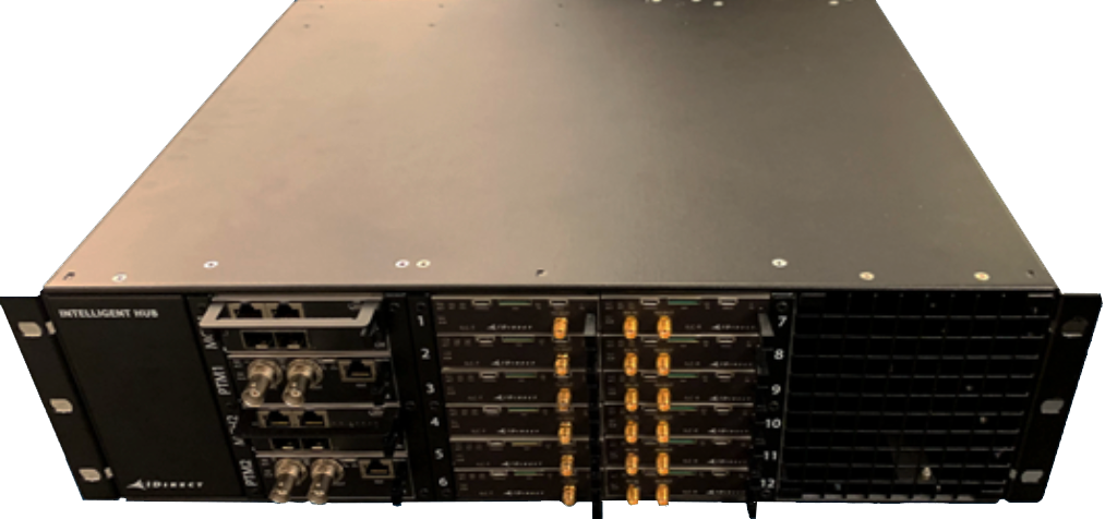
Our iHub (pictured below) also made its debut in 2021 featuring proven, standards-based micro-TCA architecture providing high- performance in a high-density compact hub supporting 100s of high-capacity beams in distributed HTS gateway architectures. Also showcased in 2021 was our IoT solution which saw successful demonstrations with our partner hiSky. The live demos proved that continuous satellite connectivity can empower applications such as telemetry and fleet tracking from moving vehicles over satellites using a highly compact flat panel antenna and IoT terminal with integrated modem.
2021 saw industry players coming together with the formation of the Digital Interface Standards (DIS) Working Group to develop an open interoperability standard for the SATCOM industry. The standard will enable all manufacturers to build interoperable technologies that work in both open and closed network topologies, delivering the most advantages at the lowest cost. Digitizing the interface between modem and RF components using the new open standard, the industry will be able to leverage the latest virtualization, cloud computing and network function virtualization technologies as well as greatly improve the performance and scale of satellite hub, gateway and modem equipment.
Supporting + Enabling Customers
This year, we have helped MNOs and Telcos to extend their reach in many different regions of the world. A tier 1 mobile network operator in Brazil deployed the Dialog® platform and state-of-the-art Mx-DMA return technology to deliver 3G, 4G and corporate internet services across the country. The network is now able to fulfill demand for cellular backhaul and corporate internet services to remote areas where terrestrial connectivity is limited or unavailable, easing business communications and access to mobile services In the Democratic Republic of Congo, Gilat Telecom installed two Dialog hubs to power cellular backhaul services for Vodacom on our Dialog platform. The solution enabled Vodacom to migrate its VSAT-based 2G network to 3G across 150 Base Transceiver Station (BTS) sites with the Base Station Controller, located in Kinshasa. The new deployment will replace traditional SCPC links and will deliver increased efficiency in order to facilitate 3G data traffic.
In Mexico, AXESS Networks deployed the first in-country Dialog XIF hub to deliver highly sought-after 4G mobile services to rural sites across the region. This effort helped connect the unconnected and bring solutions to those who had been left behind by the digital divide.
As 5G deployments begin early stages of rollout, Athens-based satellite operator Hellas Sat successfully validated hybrid 5G backhauling use cases over satellite over the Evolution® platform. Showcasing a completely seamless transition between terrestrial and satellite-based networks, the demonstration not only confirms the critical role that satellite will play in the 5G ecosystem through its capability to broaden coverage to hard-to-reach areas, but further reinforces its cellular backhaul capabilities across Hellas Sat’s satellite coverage.
Vital satellite bandwidth was delivered to the Andaman, Nicobar and Lakshadweep Islands in the Indian Ocean for BSNL on Dialog. That means that 36 atolls and 38 islands will now have access to crucial economic and social tools through the connectivity we support.
In the Philippines, Intelsat selected the Evolution platform to grant broadband services to those who need them most across the archipelago of more than 7,500 islands in Southeast Asia. Satellite technology provides a cost- effective and reliable solution for broadband delivery, which is seeing rising demand across the region.
Satellite operator Kacific was an early adopter of our Mx-DMA MRC technology that has enabled the company to provide high-speed, low- cost, ultra-reliable broadband to rural and suburban areas of the Pacific and Southeast Asia. Kacific currently operates over 8,000 terminals, including the new cost-effective MDM2010 modems in Mx-DMA MRC mode, spread across 56 beams. Kacific also used our Dialog platform to launch their first VNO-enabled cellular backhaul service for Mobile Network Operators (MNOs).
The Ka-band mobile backhaul service is available to all ISPs, telecom operators and government agencies across all the countries Kacific services throughout Asia and the Pacific.
Turksat became the first to deploy a new security feature on the SatHaul-XE solution that was developed in partnership with Xiplink. The feature supports IPsec encryption with CMPv2 digital certificate management, building upon the existing high levels of security whilst maintaining optimization and acceleration.

In the broadcast segment, we’re immensely proud of the delivery of the world’s first end-to-end demonstration of a B2C use case of Native IP, demonstrating origination, transport, reception and consumption of live OTT video over satellite.
We partnered with EKT, Broadpeak and EasyBroadcast. This demonstration proved that satellite can deliver OTT content anywhere and to any device. This has far-reaching implications as its content delivery will not be limited to entertainment, but also will enable educational institutions to reach their students, healthcare providers to offer telemedicine services and reach households that may not have a computer but do have a television so that they can enjoy access to information and content.
Connecting Incredible Journeys
This year, we have been involved with two fascinating expeditions. Earlier this year, with our partners, Telenor Maritime and Eutelsat, we were given a golden opportunity to play a key role in heightening awareness of the key role that our oceans play in enabling a sustainable environment. Together, we are providing real-time connectivity for the ONE OCEAN expedition aboard the antique sailing ship, Statsraad Lehmkuhl, as it circumnavigates the globe to raise the oceans’ profile. Real-time connectivity is key to the success of the mission. This immediate access to data, video and stories from the ship will serve to inspire and engage not only scientists but also citizens for ocean- based action towards sustainable development worldwide.
In October, we once again provided connectivity to the Belgian Agoria Solar Team as they embarked on a grueling solar race across the Moroccan Atlas Mountains. The race, which tests university students’ ability to design and build a solar car and then compete in a four-day race, was a replacement for the canceled Bridgestone World Solar Challenge, which usually takes place in Australia.
We were delighted, along with our partners Intelsat and Kymeta, to provide connectivity to the ‘brains’ car for the duration of the race, enabling the crew to access crucial connectivity and to broadcast daily Facebook Live shows to keeps fans posted on their progress. We’d like to congratulate the team on their fantastic achievement of second place.
Industry Recognition
Another theme of 2021 has been our aspiration to, and success in, technological excellence. In 2021, we won a Factory of the Future award which marks the third time we have achieved this accolade.
The ST Engineering iDirect Manufacturing Competence Centre (MCC) was recognized for its best-in-class, future-proof and sustainable manufacturing technologies and processes We also cemented our leadership and commitment to the mobility sector with the Top Mobile User Experience Innovation Award from the Mobile Satellite Users Association (MSUA). This recognition reflects our dedication to the delivery of innovative solutions that enable its customers to offer seamless connectivity as new constellations, applications and markets emerge. Our advanced SATCOM mobility solutions comprise a diverse, feature-rich set of capabilities and technologies to offer customers the utmost in choice and flexibility.
Looking Forward

When we look to the future, we aspire to build upon our heritage of innovation and excellence when it comes to all things dealing with satellite connectivity. This year has seen us thrive through challenging conditions and the solutions we have created are still at the forefront of what’s possible in the satellite space.
Tomorrow holds more promise than our industry has ever before witnessed. We look forward to taking our next steps on this journey together with our customers and partners.
UP42
UP42 looks ahead to 2022 with well-deserved optimism after chalking up several accomplishments in just two years since the company’s launch. The Berlin start-ups Earth Observation (EO) marketplace and developer platform saw revenues triple in 2021, while expanding the number of geospatial data sets ad analytics tools offered on its site to 58 and 85, respectively. Customers responded enthusiastically, placing more than 100 times the orders as in 2020.
Among the notable new offerings are satellite image data sets from Airbus, HEAD Aerospace and SI Imaging Services. These additions make the UP42 portfolio of commercial imagery the most extensive and diverse available from a single online marketplace.
“Our most significant achievement in 2021 was expanding our selection of satellite imagery products to better meet the needs of UP42 customers across all sectors,” said UP42 CEO, Sean Wiid.
UP42 opened its doors in 2019 with the goal of democratizing geospatial technologies by creating a unified online platform where users can access all the resources needed to extract meaningful information from raw data — without major investment in software and computing infrastructure. This has successfully lowered the financial and technical barriers to entry enabling businesses of all sizes to impact the commercial market.
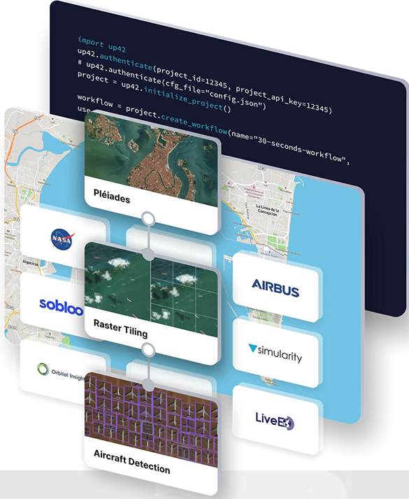
The integrated marketplace and platform offer extensive sources of data such as satellite and aerial imagery, weather data, and digital elevation models — together with processing algorithms to identify objects, detect change, and find patterns. Customers cost-effectively purchase just the data needed to cover their area of interest and leverage the platform’s cloud computing power to process and analyze the data sets.
UP42’s entry into the market could not have been better timed. With dozens of new remote sensing satellites launched later in 2021 and many more under development, geospatial users have more data sets than ever to choose from. UP42 makes it easier to choose the right data set by creating a simple API where customers can search and filter imagery from multiple satellite operators, integrate the precise data they need into scalable workflows, and even leverage their tasked data and own algorithms.
Diverse Imagery
UP42 negotiated new data distribution agreements with three satellite operators in 2021. These data sets include hyperspectral and synthetic aperture radar (SAR) imagery spanning the gamut of spatial resolutions, revisit cycles and imaging capabilities. Each image product expanded the UP42 customer base by delivering new or enhanced benefits to multiple end use applications.
“In many ways, our progress at UP42 paralleled the launch successes of the satellite imaging industry,” said Wiid.
In November, UP42 announced the availability of very high-resolution optical imagery from the Airbus Pléiades Neo constellation. Two satellites were launched in 2021, with another two slated for 2022. Pléiades Neo’s unique combination of 30 cm native spatial resolution, frequent revisit, and faster tasking/data delivery supports numerous applications, including:
• Infrastructure Monitoring – Twice-daily imaging enables government agencies, security firms, energy utilities, and other organizations to closely track changes in the infrastructure or the surrounding environment. The new Red Edge band supports detection of subtle change in plant health and growth that could impact critical infrastructure.
• Urban Mapping – In densely developed urban areas, local governments and utilities can map assets and infrastructure using very high-resolution imagery to accurately locate and identify objects as small as 30cm, or about 12 inches. Stereo imaging allows for detailed 3D mapping of built structures and surface terrain.
• Disaster Response – The ability to place acquisition orders shortly before a satellite overpass and quickly receive image products enables government organizations, insurance companies and others to respond effectively to unplanned events.
• Marine Applications – The new Deep Blue band penetrates the water column to deliver insights related to depth and water quality in the near-shore ocean environment.
Another major agreement was signed in June 2021, this one with HEAD Aerospace from China to make image data from more than 40 innovative Earth Observation satellites available on the marketplace immediately and another 40 set to be launched. The satellites’ diverse and often unique imaging capabilities include wide-swath imaging at very high-resolution, nighttime acquisitions, frequent intraday revisits, tri-stereo collection, and hyperspectral imaging.
The agreement includes imagery from multiple constellations, including SuperView, Earthscanner, Gaofen-7, DailyVision, NightVision, Hyperscan, and Tri-Stereo ZY3. A remarkable variety of operational capabilities is shared across the constellations to support numerous applications and industries:
• Large-Area Very High-Resolution Mapping – Up to 40,000 square kilometers can be covered with wide-swath (136 km) imagery captured at a half-meter spatial resolution on a single pass to support infrastructure mapping over entire states and countries.
• ntraday and Early Morning Monitoring – Designed for frequent monitoring related to energy security, defense/intelligence, and infrastructure protection, a high-resolution revisit schedule of four times per day is possible with 15-minute revisit between 09:00 and 13:30 anywhere on Earth.
• High Vertical Accuracy Mapping – Multiple satellites perform stereo imaging at high resolution for high-quality land cover and cadastral mapping. One constellation captures single-pass tri-stereo imagery validated with onboard laser altimetry data, generating large-scale 3D mapping products with vertical accuracy of 5 meters.
• Hyperspectral Imaging – Imaging in 25 spectral bands spanning the visible, near-infrared, and mid-infrared portions of the spectrum is ideal for regional natural resource management, agriculture monitoring, and mineral exploration.
• Nighttime Imaging – Monitoring and surveillance activities by government entities, energy utilities, and security organizations can be carried out around the clock with true-color, high-resolution 1m optical and video imaging during daylight and dark of night.
Early in 2021, UP42 and SI Imaging Services (SIIS) finalized a distribution agreement involving high-resolution optical imagery from KOMPSAT-3 and -3A, and SAR data from KOMPSAT-5. These data sets complement the UP42 portfolio with diverse spatial and spectral capabilities, broad dynamic ranges, afternoon acquisition times, extensive archives, and attractive price points. Key applications include:
• Detailed Land Cover Mapping – The two optical satellites capture panchromatic imagery at 50 and 40cm spatial resolution and multispectral data at 2m resolution with a 14-bit radiometric resolution that produces a broad dynamic range of pixel values, delivering more detailed and reliable feature classifications.
•Afternoon Acquisition – KOMPSAT 3/3A capture imagery at 13:30 local time, making intraday monitoring and change detection mapping a reality when combined with standard morning acquisitions by other satellites.
• All-Weather Imaging – KOMPSAT-5 acquires X-band SAR data at 85-centimeter resolution through clouds and darkness to support insights even under adverse weather conditions, such as after disasters, in cloudy tropical regions and hazy coastal zones.

Author Kevin P. Corbley is a business development consultant and marketing professional who is the owner of Corbley Communications based in Colorado. Multiple Factors Ensure Continued Growth + Success for the Satellite-Based EO Industry in 2022
As 2021 draws to a close, UP42 celebrates a year of exceptional growth highlighted by significant increases in the data sets and analytics available on our geospatial marketplace and developer platform. Much of this success, of course, is owed to the hard work of the skilled UP42 team and relentless innovation by our business partners, which will undoubtedly continue in the coming year. External factors, however, also play key roles in the achievements of any company, and such has been the case with ours. Looking ahead to 2022, we see three important phenomena shaping our business that will have major positive impacts, not just on UP42, but on the Earth Observation industry as a whole.

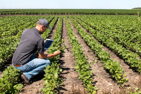
Satellite-Based Vegetation Management — Trimming shrubs near powerlines may seem of minor importance, but the deadly California wildfires of 2018 sparked by vegetation encroachment in electric transmission corridors brought the issue to international attention. Energy utilities, railways, and operators of other critical infrastructure worldwide spend millions of dollars each year to monitor vegetation in rights-of-way to prevent catastrophes that can claim lives and cost billions.
Monitoring these corridors with sensors aboard manned aircraft and drones is effective, but the process is timely and expensive — primarily because the captured data has to be reviewed by human analysts. Artificial intelligence (AI) algorithms, however, have been developed to automate this analysis and apply it to high-resolution satellite imagery. The combined speed and scalability of satellite data collection and analysis has slashed the cost of vegetation management, allowing utilities and others to monitor rights-of-way more frequently and accurately.
Automated monitoring applications like this have exploded in the past year for three key UP42 customers and will accelerate satellite data sales even further in 2022.
Government Policies and Programs — Satellite imagery is assuming a larger role on the world stage as governmental organizations increasingly rely on Earth observation technology as a cost-effective and unbiased provider of information. In some cases, government policies explicitly call out the need for satellite imagery, while in other applications, it is simply the only viable data source to address the issue at hand.
Four recent government initiatives that will drive satellite image demand include the following:
• The 2021 U.S. Infrastructure Bill will require satellite imagery to plan massive upgrades to transportation networks.
• COP26, the U.N. Climate Change Conference, will utilize satellite imagery to identify and monitor impacts of the changing climate.
• The European Commission’s CASSINI initiative supports New Space entrepreneurs and start-ups to utilize space-based technology, including Earth observation data, to build new businesses.
• The new Indian Space Association (ISpA) is building public- private partnerships and advocating policies that leverage India’s space technologies for that nation to become a leading player in the global space arena.
New Earth Observation Constellations — For decades, the goal of commercial satellite remote sensing has been to provide persistent global coverage. This dream is finally being realized thanks to the plethora of innovative new sensing platforms that have been launched in just the past year. Notable constellations include optical systems by Airbus, HEAD Aerospace, Satellogic, and Planet, as well as synthetic aperture radar (SAR) sensors by Capella Space and ICEYE.
The sheer number of satellites now makes it possible to capture imagery of any spot on Earth multiple times per day. In addition, advancements in ground segment tasking and processing mean image products can be delivered within hours of acquisition by the satellite. This combination of more frequent revisit combined with faster product turnaround is powering an exciting new spectrum of monitoring applications that have long been promised but were previously not possible.

Even better news for 2022 is the fact that additional new satellites are under development and will reach the launch pad in coming months. These constellations of deployed and planned Earth observation satellites will open new streams of revenue that will have dramatic impact on the commercial remote sensing industry and facilitate responsible stewardship of our planet for years to come.
Author Sean Wiid is the CEO of UP42