
Synthetic-aperture radar (SAR) imaging from orbit is not new — almost 40 years ago, the Spaceborne Imaging Radar (SIR) flew on two shuttle missions to image Earth from above.
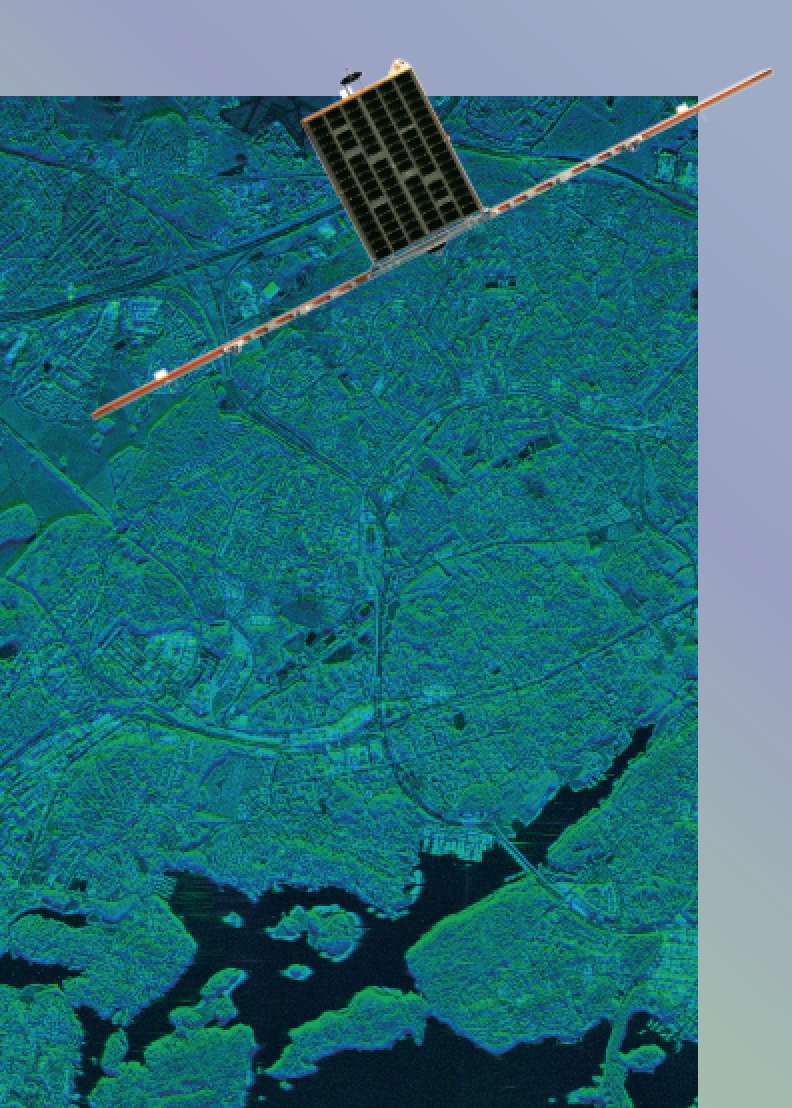
ICEYE’s SAR image from an aerial imaging campaign of Espoo, Finland.
Since then, roughly 15 publicly announced SAR satellite missions have launched. Out of those satellite missions, about half are operational today.
During their lifespan, they’ve enabled the imaging of Earth in conditions where optical has not been able to deliver the data. Regardless of the time of day or cloud cover, SAR imaging has allowed the world to see both sea and land in a new light.
The instrument actively sends its own energy down to Earth and receives that energy back, rather than relying on the Sun for visibility, and it is more flexible in its ability to see the surface at all times.
These original missions — and even the more recent ones, such as Sentinel-1B from the European Union’s Copernicus program — have one key element in common... most have had a launch mass measured in the thousands of kilograms. These larger sized missions increased the reliability of the onboard instruments, extended the lifespan of missions, or simply enabled testing of these new technologies altogether.
However, larger satellites are also extremely prohibitive when it comes to commercial and government operations. Long a dream of the satellite industry is to reduce the development and launch costs of SAR satellites to meet the increasing global need for SAR data and ICEYE has been working fervently to make that become a reality.
SAR — Starting from smaller-than-possible
ICEYE’s initial steps started in a smallsat program at Aalto University in Finland back in 2012. Prior to this program, there weren’t any national capabilities for complete satellite missions but, rather, only capabilities for participation in larger missions with individual instruments. ICEYE officially started operations in 2015 as a spin-off from that program, with a focus on synthetic-aperture radar sensor technology.
The goal directly from the start for ICEYE was to launch the smallest SAR satellite possible to meet ongoing development needs for the future. One of the key use cases that raised keen interest was to monitor Arctic sea ice for commercial and research purposes.
Naturally, there was a healthy sense of skepticism in the industry on developing a SAR satellite under the traditional mass of one or two tons. At the time, the instruments simply required satellites above that launch mass. As no other organization had ever produced a SAR satellite under 100 kg., such seemed to be an impossible feat at that time.
With this skepticism acknowledged, the initial ICEYE team explored different cubesat possibilities. They had to initially understand the synthetic-aperture radar instrument itself and the limitations and possibilities of the technology.
While the team was well-versed in nanosatellite technology, creating a SAR instrument to fit a smallsat was problematic then and remains so to this day. However, one item remained certain — it was entirely possible to create a sensor far smaller than what was currently being used on satellites around the world for an instrument of this type.
A large portion of the fast development cycle ICEYE has used has revolved around using airborne platforms to test the company’s synthetic-aperture radar instruments. Original designs and implementations were not built for a satellite as is, but rather for aerial imaging to trial sensor capabilities and to rapidly develop the overall systems further. These tests quickly validated the final size range for the first proof-of-concept satellite ICEYE-X1, below 100 kg., but above cubesat range —- firmly in the microsatellite category.
Creating a synthetic-aperture radar sensor from scratch in such a way had the added benefit for ICEYE to enable creating a completely platform agnostic instrument. As a result, today ICEYE offers satellite and aerial SAR imaging for governmental and commercial entities.
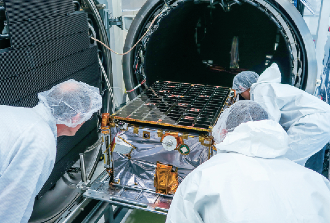
ICEYE-X1 being prepared for bake-out.
Benefits of smaller SAR satellites
Up until now, SAR instruments were being launched on satellites the size of a school bus. One of the main benefits of using smaller satellites than those large spacecraft is that they are more conducive to commercial operations, especially in regard to cost efficiency. ICEYE’s satellites are a 100 times less expensive for the development and manufacturing cycles than traditional SAR satellites.
When adding in the cost of launch, simply being able to launch 20 or more satellites for the cost of one satellite enables new opportunities for radar imaging. While optical satellite constellations are already in use, a synthetic-aperture radar constellation remains unachieved.
That is what ICEYE is aiming at and is well on its way to become the first to deliver a constellation of SAR satellites that will bring the added benefit of distributing the SAR instrument reliability onto multiple satellites rather than just a single satellite.
There are two key concerns regarding SAR instrument development for smaller than traditional platforms. The first is that there is a natural limitation on how small your instrument can physically be constructed before losing too much resolution in the final data that can be gathered. The second is that this task is extremely difficult to execute.

ICEYE aerial radar imaging in progress — through clouds and darkness.
ICEYE-X1 mission
ICEYE has come a long way in developing SAR technologies since the concept was initiated in 2012. At the start of January 2018, ICEYE launched ICEYE-X1, the company’s first proof-of-concept satellite mission equipped with a SAR instrument.
This mission will achieve several major milestones for ICEYE, locally and globally, including being the world’s first SAR satellite under 100 kg. to be deployed in space as well as the first Finnish commercial satellite ever launched.
The goal of the ICEYE-X1 mission is to validate the on orbit performance of the satellite’s sensor and to start pilot operations with select customers. The Earth Observation (EO) data gathered in this SAR imaging can be used to help monitor Arctic sea ice movements, marine oil spills, prevent illegal fishing and even help first responders in emergency situations. The use cases for radar imaging are vast, as ICEYE continues to scale out its operations to a multitude of industries, for both commercial and governmental purposes.
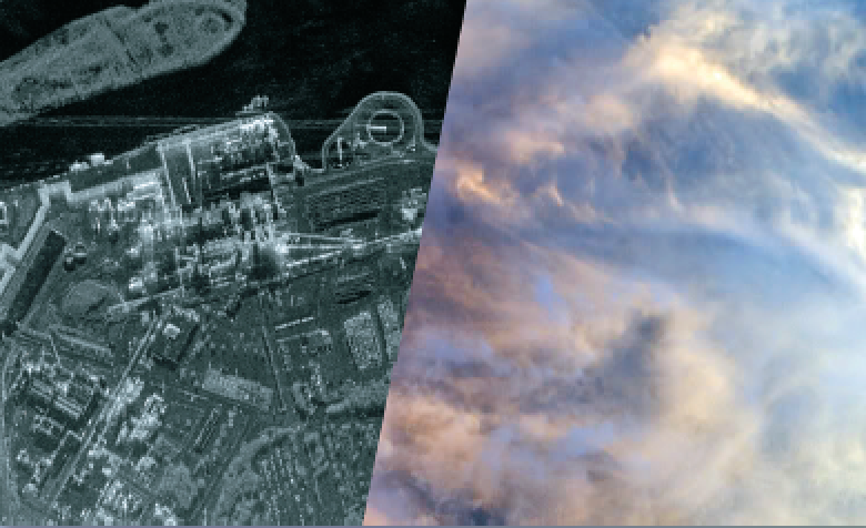
SAR peers through the clouds...
ICEYE-X2 and ICEYE-X3 for 2018
ICEYE’s plans for 2018 doesn’t stop at one single mission. ICEYE will be launching two or more additional proof-of-concept missions in 2018.
There are three major goals for these additional missions.
• First, the missions are intended to help the ICEYE team further develop and demonstrate the capabilities of the company’s SAR technology.
• Second, these missions are used to further test and develop exactly how ICEYE’s SAR constellation will be used to deliver data to customers for different use cases.
• Third, the missions are a part of a risk mitigation strategy where several different launch providers are verified for future capabilities, including for integration and timelines.
After ICEYE’s missions
ICEYE’s innovative smallsat approach allows for a distribution of a large amount of sensor units through a variety of orbital planes and local time nodes. This efficiency vastly increases the availability of acquisition times and locations and enables launching multiple SAR satellites at costs that previously had to be allocated for just a single mission. Previously, traditional fixed orbital planes and a limited number of sensors created a cap on what would be feasible for global SAR data acquisition.
During 2018, ICEYE plans to have more commercial SAR satellites on orbit than any other organization on Earth.
During 2019 and 2020, ICEYE is aiming to distribute a constellation of 18 or more SAR satellites to orbit, each satellite offering more capabilities than the satellite preceding it. With this high number of sensors on orbit, ICEYE can guarantee revisit times any time of day, or in any weather condition. These capabilities completely enable new, reliable and timely solutions to be built on top of SAR data, capabilities that were previously unattainable.
While optical data currently has a lead on how often an overpass occurs, cloud cover and a distinct inability to see in the dark leaves roughly 75 percent of imaging opportunities unused. Paramount is that SAR satellite constellations become established to increase the global reliability to a level that meets the requirements of commercial and governmental entities.
www.iceye.com/

Pekka Laurila is the Chief Financial Officer and Co-Founder of ICEYE. As CFO, Laurila has been instrumental in establishing company-wide financial procedures and raising funds for ICEYE, which has now received more than $15 million in recent capital infusions. As a Nordic native from Finland watching the Arctic ice caps melt, Laurila joined forces with Rafal Modrzewski to create synthetic-aperture radar (SAR) smallsats in hopes of ensuring the sustainability of global warming research.
Prior to co-founding ICEYE, Laurila played an instrumental role in Finland’s Aalto University Nanosatellite Program, where he studied as a student of the Engineering and Geoinformation Systems program. Using this engineering and entrepreneurial experience, Laurila helped to co-found a spin-out company of Aalto University, which would later become ICEYE.