Honeybee Robotics + NASA—Six Projects Funded
Honeybee Robotics Spacecraft Mechanisms Corporation has received six NASA awards for technology development through the Small Business Innovation Research (SBIR) and Small Business Technology Transfer (STTR) programs.
The awards will fund new approaches to planetary sampling systems, spacecraft mechanisms, and unmanned ground vehicles for Earth and Lunar applications.The six awards cover the following research areas:
Adaptive LIDAR Vision System for Advanced Robotics (SBIR Select Phase I project) to create a new compact technology for navigation of unmanned ground vehicles.
High Temperature Venus Drill and Sample Delivery System (SBIR Phase I project), which will create a hybrid system combining a Venus Drill and Trencher capable of acquiring surface and subsurface regolith as well as pulverized rocks (i.e., cuttings) for scientific analysis.
Pyramid Comet Sampler (SBIR Phase I project) to develop an Inverted Pyramid sampling system, in which each face of the pyramid includes an independently-actuated cutting blade to pierce into the surface of a comet at a steep angle and sample the material with minimal tangential forces.
Extreme Environment Sampling System Deployment Mechanism (SBIR Phase I project), which will integrate previously-developed extreme temperature actuators with functional elements to demonstrate a complete multi-DOF deployment mechanism suitable for candidate surface missions to Venus or a comet.
Flywheel Energy Storage for Lunar Rovers & Other Small Spacecraft (SBIR Phase I project), a project to explore alternatives to radiological thermal control systems, instead using an extreme environment flywheel energy storage system that could supply enough power to heat the critical electronics during the Lunar night.
Free-Flying Unmanned Robotic Spacecraft for Asteroid Resource Prospecting and Characterization (STTR Phase I project), under development with Embry-Riddle Aeronautical University (ERAU) to create an integrated autonomous free-flyer robotic spacecraft system that supports the exploration and subsequent resource utilization of asteroids and other planetary bodies and moons.
To learn more, visit Honeybee Robotics’ infosite at http://www.honeybeerobotics.com/services/space/
* * * * * * * * *
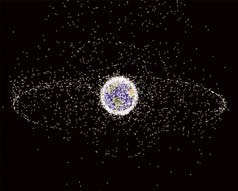
University of Alabama in Huntsville—Cleaning Up The Spatial Junkyard
The biggest-sized junkyard in the world orbits Earth, and a University of Alabama in Huntsville (UAH) aerospace systems engineering graduate student says it’s time to get active about reducing the debris field before we reach a tipping point beyond which we may not be able to do much.
“Debris is the hot topic that nobody wants to touch,” said Tom Percy. Percy is the primary author with his advisor, UAH Mechanical & Aerospace Engineering professor Dr. D. Brian Landrum, of a paper that outlines methods and policies that could be employed to mitigate space debris.
“I saw a need in the space community, with my systems engineering background, to walk people through the thought processes of how you apply a systems engineering approach to policy questions,” Percy says. “How do we bring the discussion to a subset of solutions we can ultimately implement?”
In early April, according to news reports, the International Space Station (ISS) had to change position to avoid a space debris field of parts from an old Ariane 5 rocket launched by the European Space Agency that came within 1,000 feet of the station. It was the second time in three weeks ISS had to sidestep space junk.
Everything that gets shot into LEO eventually becomes junk—even, one day, ISS itself. It’s just a matter of time.
Time is also a factor that can work against proper disposal of satellites nearing the end of their lives. Satellites now in orbit have been designed to carry a bit more fuel in their tanks for use when they get old, to propel them into an orbit where they will re-enter the atmosphere and burn up within 25 years or so.
However, because the current standards for being a good space neighbor by taking out your garbage are guidelines rather than mandates, there’s nothing in place now to prevent the owner of a communications satellite from using that last bit of fuel to reboost its orbit and add more years to its longevity.
That’s one way Percy says we get large space debris from dead satellites, along with spent rocket stages and panels and other big parts that come off in flight, or when space junk collides with other space junk or orbiting working satellites.
In 2009, the Iridium 33 and Cosmos 2251 satellites hit in the first accidental hypervelocity collision between two intact artificial satellites in Earth orbit. Iridium was an operational communications satellite. Cosmos was Russian space junk and no longer actively controlled.
From the perspective of populated areas on Earth, big space junk is a worry.
“What we’re really concerned about is the big stuff that comes in uncontrolled and breaks up in the atmosphere into big chunks,” Percy says. Larger objects are more likely to have parts survive re-entry, posing a potential risk to people on the ground. Think Skylab, big parts of which were strewn across Australia, if it had landed in New York.
But the biggest worry for satellites operating in orbit comes from the smaller debris, the stuff that’s 1 centimeter to 10cm in size—from marble to softball sized.
“We can’t see that stuff from the ground, we can’t see it with radar and we can’t see it with satellites,” Percy says. Yet small debris has the greatest potential to damage working satellites, rockets in flight or even the ISS. The big stuff we have a pretty good handle on, as far as where it is, he says. In the U.S., the Dept. of Defense tracks it. If we know where it is, we can move to avoid running into it, Percy says. Because we can’t see the smaller stuff, NASA predicts where it is but avoiding it is nearly impossible right now. Of course, tracking and removal are two very different things.
In 1978, NASA scientist Donald J. Kessler proposed a scenario now known as the Kessler Syndrome or Kessler Effect, where the density of space junk reached a point that collisions between objects would cause a cascade that would generate further debris to promote added collisions, potentially rendering space exploration unfeasible for generations.
In his paper, Percy outlines policy initiatives and engineering solutions that could prevent that tipping point from being reached. The keystone issue is how to achieve a balance between commercial economic interests, practicality, regulation and global governmental cooperation, he said.
Working to equip future craft for their eventual removal could have a large impact, he says, because the size of the space community is growing quickly, from 16 nations two decades ago to 46 now.
Getting relatively new and emerging spacefaring countries like Saudi Arabia and India onboard with debris control that starts at the design and launch phases will do much to reduce the future problem, according to Percy.
Engineering solutions for future spacecraft depend on type and size, as well as orbit. A deployable sail attached to a satellite could gradually slow it in LEO so it eventually burns up in the atmosphere. Or a small and light dedicated ion propulsion pack can nudge a craft into contact with the atmosphere.
“Implementing these engineering solutions on satellites before launch is becoming more critical in the burgeoning age of cube satellites, when scores of satellites can be launched from a single rocket,” says Dr. Landrum.
Pre-launch engineered solutions will probably have to be coupled with some form of active debris removal system to clear older debris and avoid the Kessler Syndrome, Percy says. “We’re investing some time and resources into active debris removal and how that can be accomplished now.”
It’s the point where the technology interfaces with governments and policies that still has to be mapped out.
“The way the regulations are now, they are more like guidelines,” Percy says. So should the U.S. work with entities like the United Nations, which has a committee working on space use, or unilaterally go ahead with its own efforts?
“One possibility is that, yeah, we just go ahead and do it and show that it can be done,” said Percy.
In space, once a craft is launched it is the country that launched it that carries the responsibility for it and not any commercial entity that may have launched it. China and Russia are the biggest owners of space junk. Should the U.S. only concern itself with its own debris? Despite these difficult questions yet to be answered, Percy says he’s optimistic that a set of solutions will be in place one day.
This story is based on materials provided by University of Alabama in Huntsville http://www.uah.edu/
* * * * * * * * *
Lockheed Martin + NOAA—Modules Movement Completed For GOES-R
The two large modules of the first GOES-R series weather satellite spacecraft were delivered to a cleanroom at Lockheed Martin’s [NYSE: LMT] Space Systems facility near Denver—the Geostationary Operational Environmental Satellite-R series (GOES-R) is NOAA’s next-generation geostationary weather satellites.
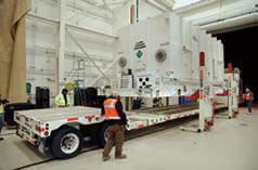
A large System Module was shipped by truck from Newtown, Pennsylvania, where it was developed to a Lockheed Martin facility near Denver. Photo courtesy of Lockheed Martin.
With the delivery of the system module and the propulsion module, the weather satellite will now undergo the important integration and testing phase so that it can be available in late 2015 for a launch in early 2016.
“The arrival of the propulsion and systems modules in Denver represents a significant milestone for the program. We are looking forward to the initial power up of the combined modules in a few weeks,” said Tim Gasparrini, vice president and program manager for the GOES-R series at Lockheed Martin Space Systems Company.
The system module of the A2100-based satellite was built at Lockheed Martin’s Newtown, Pennyslvania, facility. It houses the three major electrical subsystems, Command and Data Handling, Communication, and Electrical Power.
The propulsion module recently underwent integration of its engines, fuel tanks and various propulsion components at the company’s Mississippi Space and Technology Center on NASA’s Stennis Space Center.
Once the system module and propulsion module are mated in July, the spacecraft will move onto the payload integration, functional testing and environmental testing phases of the program.
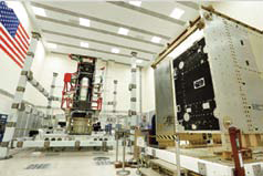
The Propulsion Module (left) and System Module (right) of the first GOES-R series weather satellite arrived in Lockheed Martin’s cleanroom near Denver where they will now undergo integration and testing. Photo courtesy of Lockheed Martin.
Data from NOAA’s GOES satellites provides accurate real-time weather forecasts and early warning products to NOAA’s National Weather Service and other public and private sectors.
The advanced spacecraft and instrument technology on the GOES-R series will vastly improve forecasting quality and timeliness, generating significant benefits to the U.S. and Western Hemisphere in the areas of public safety, severe weather monitoring, space weather prediction, ecosystems management, commerce and transportation.
In addition to four satellites in the series (R, S, T and U), Lockheed Martin is also designing and building the Solar Ultraviolet Imager (SUVI) and the Geostationary Lightning Mapper (GLM) instruments that will each fly aboard each of the spacecraft. The SUVI was recently installed on the GOES-R satellite’s sun pointing platform.
The NOAA Satellite and Information Service funds, manages, and will operate the GOES-R series satellites. NASA oversees the acquisition and development of the GOES-R spacecraft and instruments for NOAA.
The program is co-located at NASA’s Goddard Space Flight Center in Greenbelt, Maryland.
For further information, please visit http://www.lockheedmartin.com/us/news/press-releases/2014/may/0501-ss-goesr.html
* * * * * * * * *
NOAA—Primary Placement For Suomi NPP
The NOAA/NASA Suomi NPP satellite is now the primary operational polar-orbiting spacecraft for NOAA’s operational weather forecasting mission.
The National Weather Service (NWS) uses Suomi NPP data in its numerical weather prediction models. Observations from the satellite are improving the accuracy and extending the range of global forecasts three to seven days in advance of significant weather events, including hurricanes and winter storms. Suomi NPP has priority within the day-to-day operations of NOAA’s Satellite and Information Service (NESDIS) and replaces NOAA-19 as the primary satellite. NOAA-19 will remain a critical part of NOAA’s polar constellation and provide valuable contributions to NWS forecasts.
Designating new satellites as primary is a regular part of NESDIS’ satellite lifecycle. As a new satellite and instruments become available and are proven, they rise to the primary position.

“The sounding sensors on the Suomi NPP satellite provide data that extend the legacy of previous operational and research satellites to support operational medium-range numerical weather prediction (NWP) modeling,” said Dr. William Lapenta, Director of NOAA’s National Centers for Environmental Prediction.
Suomi NPP is part of NOAA’s next generation Joint Polar Satellite System (JPSS) constellation of polar-orbiting environmental satellites. These satellites gather global measurements of atmospheric, terrestrial and oceanic conditions—including atmospheric temperature, atmospheric moisture, hurricane intensity, clouds, rainfall, dense fog, volcanic ash, fire locations, smoke plumes, sea and land surface temperatures, vegetation, snow and ice cover, and ozone.
Suomi NPP also provides continuity for NASA’s Earth Observing System (EOS) and is a bridge between NOAA’s legacy Polar Orbiting Environmental Satellites (POES) and the JPSS-1 satellite, which is scheduled to launch in 2017.
NWS uses JPSS data in models for medium- and long-term forecasting. JPSS also enables forecasters to monitor and predict near term weather in polar regions, particularly Alaska; and to track weather at night. It enables scientists to monitor and predict weather patterns with greater accuracy and to study long-term climate trends by extending the more than 30-year satellite data record.
Suomi NPP was launched from Vandenberg Air Force Base on October 28, 2011, and has since logged more than 12,000 orbits. The instruments on board the satellite are: Advanced Technology Microwave Sounder (ATMS), Cross-track Infrared Sounder (CrIS), the Visible Infrared Imaging Radiometer Suite (VIIRS), Ozone Mapping and Profiler Suite (OMPS) and Clouds and the Earth’s Radiant Energy System (CERES).
More info http://www.noaa.gov/
* * * * * * * * *
Hunter Communications + Nanometrics—Sensing Seismicity
Hunter Communications has teamed with Nanometrics, one of the world’s leading manufacturers of seismology systems and instrumentation, to develop an induced seismic and microseismic monitoring application via satellite for oil and gas drilling sites where hydraulic fracturing (“fracking”) is employed.
The application is deployed by the Nanometrics LIBRA very small aperture terminal (VSAT) system to monitor oil and gas drilling sites in real-time to determine whether fracking is triggering or inducing seismicity, either on the drill site or within the region. Exploration geophysicists and seismologists use the LIBRA system to make strategic, real-time decisions about their operations based on the data and analysis they receive from the new application.
Nanometrics initially developed the LIBRA VSAT system specifically for ultra-low power usage, a critical factor when installing systems far from any electrical grid.
The LIBRA technology has been deployed at hundreds of remote locations globally to provide real-time monitoring of volcanoes, earthquake zones and fault lines, including diverse locations such as volcanoes in Peru and Cyprus and geological fault lines stretching from Trinidad
to Ghana.
The critical seismic data is collected by Nanometrics seismometers with its proprietary instrumentation and networking technology and transmitted by satellite through the LIBRA networks. It is delivered in real-time to scientists at universities and governmental organizations across the globe..
“Oil and gas companies are now proactively establishing monitoring sites surrounding their wells, and we are partnering with the scientific community to delve deeper into the science of microseismicity,” said Neil Spriggs, Nanometrics CEO of Global Operations. “Ultimately, we believe that many more of these firms will choose to closely monitor their operations using the real-time data that we provide, which enables them to stop operations if induced events approach the threshold of felt earthquakes.”
The microseismic monitoring system application is currently in use in Northeastern British Colombia where there are a significant number of well operators.
Nanometrics and Hunter Communications Canada provide scientists with real-time satellite access to all the data collected from these wells. The data is being analyzed as part of an ongoing research project to study both the short-term and long-term effects that fracking will have on seismic activity in that area.
“It is critical for the scientific community to learn about the effects of hydraulic fracturing and obtain factual data instead of anecdotes and conjecture on whether fracking does indeed cause meaningful effects to the surrounding area,” Spriggs said. “Obtaining this information is a significant benefit, not just for local populations, but also for oil and gas companies, who will use this information to improve their technologies and procedures.”
Several Canadian networks have deployed LIBRA satellite systems, including GeoScience BC, Alberta Energy Regulator and the University of Ottawa Yukon Network.
The University of Ottawa turned to Nanometrics and Hunter for a turnkey, real-time seismic network consisting of seven Libra VSAT stations as part of a five-year study to better understand seismicity and crustal behavior in the Mackenzie Mountains and River Basin region of the Yukon. This area is known to be the most seismically active in Canada.
Pascal Audet, Assistant Professor, Faculty of Science, Department of Earth Sciences, University of Ottawa, will use the seismic data to determine earthquake patterns and map faults in Canada’s northwest.
“Despite being one of the most seismically active regions in Canada, this area remains very poorly studied due to a lack of seismic station coverage,” Audet said. “This new network bridges that gap and allows us to determine the location and magnitude of small earthquakes very accurately and estimate seismic hazard in this area.”
Brent Perrott, President of Hunter Communications, stated that working with Nanometrics on the many seismic monitoring systems is of critical importance: “These networks enable real-time scientific monitoring, which is improving industry standards and translating into a safer industry.”
For further details, please visit the Hunter Communications infosite at http://www.huntercomm.net/
The Nanometrics infosite is located at http://nanometrics.com/
* * * * * * * * *
Advantech Wireless—The Newest Jewel Debuts
Advantech Wireless Inc. has announced that it has successfully introduced the New SapphireBlu™ Series 6.6kW X-Band Rackmount UltraLinear™ GaN SSPA/BUC, the ultimate solution for wide bandwidth, ultra high power satellite teleport uplinks.
Awarded as Most Innovative Product of the Year 2013 and Teleport Technology of the Year 2014, Advantech Wireless’ SapphireBlu™ Series of UltraLinear™ GaN based High Power Amplifiers are leading the way with ground breaking performance and pioneering technology.
High power density GaN Technology based SSPA concept, in a compact, indoor modular package with Built in Redundancy and Built in Arc Detection Circuitry.
The Highest Linear Power Available “Our new high power density, GaN based SSPA concept, offers the maximum power/bandwidth combination,” stated Cristi Damian, VP Business Development at Advantech Wireless. “We are helping our customer save Millions of dollars in Energy Cost, Satellite Bandwidth and CAPEX.”
The New SapphireBlu Series of UltraLinear GaN technology based SSPAs and BUCs from Advantech Wireless, exceed all barriers between Klystrons, TWTs and SSPAs, backed by over 25 years of Outdoor SSPA design and manufacturing, combined with the traditional Advantech Wireless features.
Advantech Wireless, an ISO 9001: 2008 certified corporation, is a leading-edge wireless broadband communications solution provider.
Advantech Wireless designs, manufactures and deploys networking for broadband connectivity, broadcast solutions, video contribution and distribution, mobile 2G, 3G and LTE backhaul and DTH & DTT video distribution,
using satellite and terrestrial wireless communications.
The products include VSAT Hubs and Terminals, world-leading GaN technology High Power Amplifiers (SSPAs), Block-Up Converters (SSPB), Frequency Converters, Satellite MCPC/SCPC Modems, fixed and deployable Antennas, Antenna Controllers, Terrestrial Microwave Radios, Routers and ruggedized military products.
Learn more at the company’s infosite: http://www.advantechwireless.com/